Distance - Draw to Measure
Contains adsIn-app purchases
3.4star
144 reviews
50K+
Downloads

Everyone
info
About this app
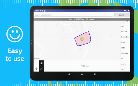
Measure Distance & Area on Maps — Just Draw!
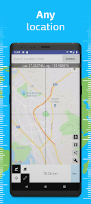
Quickly calculate distance and area by drawing on the map. Perfect for walking, running, biking, hiking, land surveying, farming, forestry, and trip planning. Whether you're checking property boundaries, planning a route, or estimating land size, this app makes it fast and easy.
Usage
-------
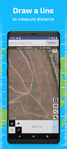
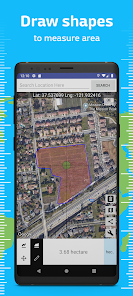
Simply touch the screen to begin measuring:
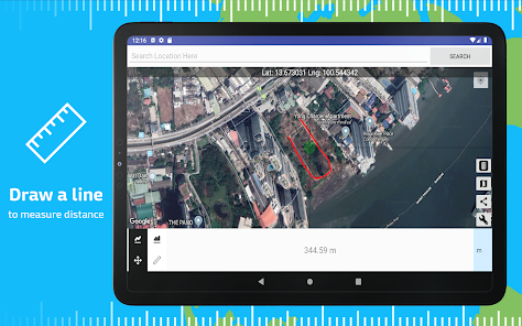
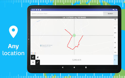
✔️ Draw lines to calculate total distance
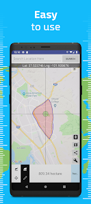
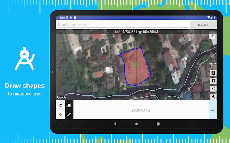
✔️ Draw closed shapes to calculate land or area size
✔️ Accurate results based on Earth curvature
Features
---------
• Move or Measure mode — pan the map or start drawing instantly
• Switch between Distance and Area modes anytime
• Choose units: meters, kilometers, miles, feet, acres, hectares, and more
• Reset easily with the Delete button
• Share results via apps or messages
• Works offline once the map is loaded
• Supports GPS-based measurement and manual drawing
Great for measuring routes, land plots, farm fields, building lots, or outdoor activities.
Ideal tool for GPS mapping, property planning, engineering estimates, or casual use on the go.
Download now and turn your map into a powerful smart measurement tool!
Quickly calculate distance and area by drawing on the map. Perfect for walking, running, biking, hiking, land surveying, farming, forestry, and trip planning. Whether you're checking property boundaries, planning a route, or estimating land size, this app makes it fast and easy.
Usage
-------
Simply touch the screen to begin measuring:
✔️ Draw lines to calculate total distance
✔️ Draw closed shapes to calculate land or area size
✔️ Accurate results based on Earth curvature
Features
---------
• Move or Measure mode — pan the map or start drawing instantly
• Switch between Distance and Area modes anytime
• Choose units: meters, kilometers, miles, feet, acres, hectares, and more
• Reset easily with the Delete button
• Share results via apps or messages
• Works offline once the map is loaded
• Supports GPS-based measurement and manual drawing
Great for measuring routes, land plots, farm fields, building lots, or outdoor activities.
Ideal tool for GPS mapping, property planning, engineering estimates, or casual use on the go.
Download now and turn your map into a powerful smart measurement tool!
Updated on
Safety starts with understanding how developers collect and share your data. Data privacy and security practices may vary based on your use, region, and age. The developer provided this information and may update it over time.

No data shared with third parties
Learn more about how developers declare sharing

No data collected
Learn more about how developers declare collection

Data is encrypted in transit

You can request that data be deleted
What’s new
Update framework versions
App support
About the developer
MAPNITUDE COMPANY LIMITED
contact@mapnitude.com
2/1 Soi Phokaew 3 Yaek 19
BANG KAPI
10240
Thailand
+66 96 765 4545


