
Avia Maps Aeronautical Charts
Ilova ichida xaridlar
4,3star
1,68 ming ta sharh
100 ming+
Yuklanmalar

Hamma uchun
info


Bu ilova haqida
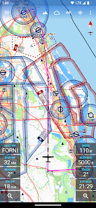
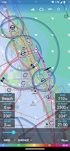
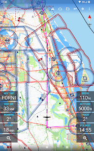
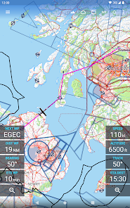
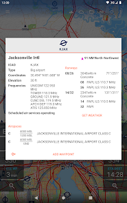
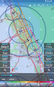
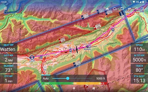
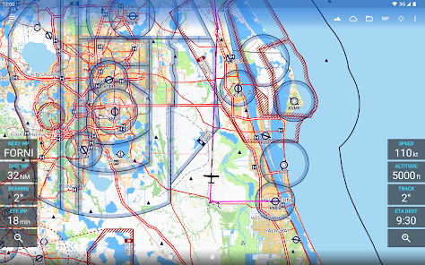
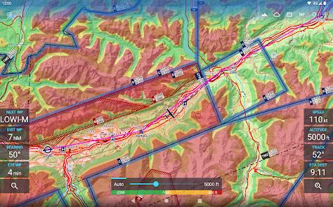
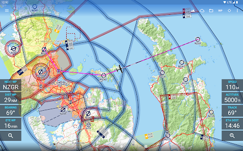
The reliable and straightforward aviation maps for pilots and aerospace enthusiasts around the world. The app is suited for pre-flight planning as well as in-flight navigation. Simply choose any 5 by 5 degree area on earth and download relevant data for offline use. The map features over 65000 airports, 9000 navaids and 15000 waypoints around the globe, just as airspaces for currently 62 countries on all continents (except Antarctica). Countries with airspace data include the United States and Canada, Europe, Australia and New Zealand.
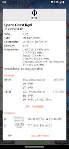
Global, high resolution weather forecasts from the German DWD and US American NOAA provide accurate map layers for cloud cover, ceiling, precipitation, wind on the ground as well as aloft. The data is downloaded onto the device, so you can check the forecast even during flight without cell reception. To retrieve the latest METAR and TAF at your destination airport it is integrated with Avia Weather.
A digital elevation model supports you with planning your route in the mountains. During flight the terrain overlay will dynamically color hills and mountains on the map depending on your current altitude to increase your situational awareness.
To enhance safety, Avia Maps can display traffic information from your favorite ADS-B receiver or from the SafeSky app directly on the map. It supports receiving traffic data using the GDL90 format, which is supported by most portable ADS-B receivers like SkyEcho or Stratux. If you do not have a receiver, SafeSky can provide traffic data using an internet connection only.
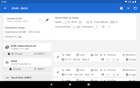
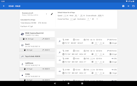
For the most accurate performance calculations you can create multiple aircraft profiles from handbook values for climb performance, fuel consumption etc. Route calculations will use these profiles and even consider engine type and fuel burn for climb performance, employing common formulae used in aerospace engineering. From as little as four carefully chosen data points the app can accurately recreate the climb performance diagram in your POH.
For clarity and commonality to paper charts the map is themed in the style of ICAO Annex 4 (Aeronautical Charts). If you use the app on multiple devices you can synchronize your routes, aircraft profiles and user waypoints between them.
This is a trial app with full features. After an evaluation period of 30 days you will have to buy a perpetual license from within the app or subscribe to the professional tier.
Global, high resolution weather forecasts from the German DWD and US American NOAA provide accurate map layers for cloud cover, ceiling, precipitation, wind on the ground as well as aloft. The data is downloaded onto the device, so you can check the forecast even during flight without cell reception. To retrieve the latest METAR and TAF at your destination airport it is integrated with Avia Weather.
A digital elevation model supports you with planning your route in the mountains. During flight the terrain overlay will dynamically color hills and mountains on the map depending on your current altitude to increase your situational awareness.
To enhance safety, Avia Maps can display traffic information from your favorite ADS-B receiver or from the SafeSky app directly on the map. It supports receiving traffic data using the GDL90 format, which is supported by most portable ADS-B receivers like SkyEcho or Stratux. If you do not have a receiver, SafeSky can provide traffic data using an internet connection only.
For the most accurate performance calculations you can create multiple aircraft profiles from handbook values for climb performance, fuel consumption etc. Route calculations will use these profiles and even consider engine type and fuel burn for climb performance, employing common formulae used in aerospace engineering. From as little as four carefully chosen data points the app can accurately recreate the climb performance diagram in your POH.
For clarity and commonality to paper charts the map is themed in the style of ICAO Annex 4 (Aeronautical Charts). If you use the app on multiple devices you can synchronize your routes, aircraft profiles and user waypoints between them.
This is a trial app with full features. After an evaluation period of 30 days you will have to buy a perpetual license from within the app or subscribe to the professional tier.
Oxirgi yangilanish
Xavfsizlik — dastur ishlab chiquvchilar maʼlumotlaringizni qanday jamlashi va ulashishini tushinishdan boshlanadi. Maʼlumotlar maxfiyligi va xavfsizlik amaliyotlari ilovadan foydalanish, hudud va yoshga qarab farq qilishi mumkin. Bu axborot dastur ishlab chiquvchi tomonidan taqdim etilgan va keyinchalik yangilanishi mumkin.

Tashqi hamkorlarga hech qanday axborot ulashilmagan
Dastur ishlab chiquvchilar axborot ulashilishini qanday aytishi haqida batafsil

Ushbu ilova quyidagi axborot turlarini toʻplashi mumkin
Joylashuv, Men haqimda va yana 4 ta

Maʼlumotlar uzatish vaqtida shifrlanadi

Maʼlumotlarni oʻchirishni soʻrashingiz mumkin
Reytinglar va sharhlar
4,3
1,37 ming ta sharh
Nima yangiliklar
Performance: Improved the performance when opening the Routes Management Dialog in case there are many routes saved.
Bugfix: When changing the altitude unit between meter and feet while the Terrain Overlay was visible the app initially drew the overlay for the previously selected altitude (old unit) with the color grading based on the new unit.
Minor bugfixes and performance improvements.
Bugfix: When changing the altitude unit between meter and feet while the Terrain Overlay was visible the app initially drew the overlay for the previously selected altitude (old unit) with the color grading based on the new unit.
Minor bugfixes and performance improvements.


