
OpenRunner : bike & hike maps
In-app purchases
3.3star
7.74K reviews

Everyone
info
500K+
Downloads

About this app
OpenRunner, the outdoor application developed in Annecy at the heart of the French Alps, is your ultimate companion for creating, planning, and tracking your sportive and leisure outdoor adventures, directly from your smartphone!
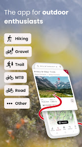
Whether you're passionate about cycling, mountain biking, trail running, hiking, horse riding, or even skiing, OpenRunner is the essential app for creating and exploring new routes. So, shall we plot together?
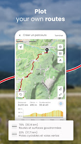
- Plot a route. Directly from your smartphone, you can easily, in just a few clicks, plot a route according to the activity chosen (running, trail running, hiking, cycling, mountain biking, Gravel…) that matches your current desires and abilities thanks to the real-time display of distance and elevation gain, mountain passes to cross, estimated time...
- Search for a route. Out of inspiration? Search and find the route that suits you among several million routes shared by the OpenRunner community! Filter by locality, distance, elevation gain, or activity to find the outdoor experience that suits you.
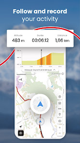
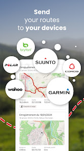
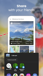
- Follow, record, share. OpenRunner gives you the ability to track your progress from your smartphone or your GPS device (watch, counter), whether you are following a trace or not, as well as to record your activity. Add photos, points of interest, comment, and share your route if you wish with other community members.
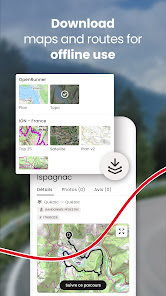
- Offline mode. When the network lets you down, OpenRunner does not, wherever you are! You can download maps for an offline use of the application.
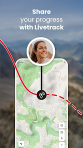
- Safety first. With the LiveTrack feature, you will be tracked to the letter! LiveTrack is about reassuring and being reassured, setting out with peace of mind, safely, without worrying your friends and relatives... LiveTrack indeed allows them to follow your progress in real time on a map and to remotely check your position, speed, and altitude.
With EXPLORER, take it to the next level! Our subscription gives access to many features(*) that make route creation easier and enrich your experience. It's simple, everything becomes possible. You won't be able to do without it!
- Specialized and precise mapping worldwide: IGN France maps with 3 backgrounds available (Top 25, Scan 25 Tour and Plan v2), IGN Belgium, IGN Spain, Luxembourg, Norway, Sweden, Finland, SwissTopo...
- Unlimited map downloads by area or along a route for offline use.
- Route creation without distance or number of waypoints restrictions.
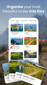
- Organizing routes into unlimited and customizable lists.
(*) Other features are available on the computer like Google Street View, adding POIs (points of interest), full-screen mode, setting a new starting point, multi-route display...
And if quality is present on OpenRunner, it's mostly thanks to all the user feedback! So for any questions, suggestions, or improvements, write to us at: app@openrunner.zendesk.com
Whether you're passionate about cycling, mountain biking, trail running, hiking, horse riding, or even skiing, OpenRunner is the essential app for creating and exploring new routes. So, shall we plot together?
- Plot a route. Directly from your smartphone, you can easily, in just a few clicks, plot a route according to the activity chosen (running, trail running, hiking, cycling, mountain biking, Gravel…) that matches your current desires and abilities thanks to the real-time display of distance and elevation gain, mountain passes to cross, estimated time...
- Search for a route. Out of inspiration? Search and find the route that suits you among several million routes shared by the OpenRunner community! Filter by locality, distance, elevation gain, or activity to find the outdoor experience that suits you.
- Follow, record, share. OpenRunner gives you the ability to track your progress from your smartphone or your GPS device (watch, counter), whether you are following a trace or not, as well as to record your activity. Add photos, points of interest, comment, and share your route if you wish with other community members.
- Offline mode. When the network lets you down, OpenRunner does not, wherever you are! You can download maps for an offline use of the application.
- Safety first. With the LiveTrack feature, you will be tracked to the letter! LiveTrack is about reassuring and being reassured, setting out with peace of mind, safely, without worrying your friends and relatives... LiveTrack indeed allows them to follow your progress in real time on a map and to remotely check your position, speed, and altitude.
With EXPLORER, take it to the next level! Our subscription gives access to many features(*) that make route creation easier and enrich your experience. It's simple, everything becomes possible. You won't be able to do without it!
- Specialized and precise mapping worldwide: IGN France maps with 3 backgrounds available (Top 25, Scan 25 Tour and Plan v2), IGN Belgium, IGN Spain, Luxembourg, Norway, Sweden, Finland, SwissTopo...
- Unlimited map downloads by area or along a route for offline use.
- Route creation without distance or number of waypoints restrictions.
- Organizing routes into unlimited and customizable lists.
(*) Other features are available on the computer like Google Street View, adding POIs (points of interest), full-screen mode, setting a new starting point, multi-route display...
And if quality is present on OpenRunner, it's mostly thanks to all the user feedback! So for any questions, suggestions, or improvements, write to us at: app@openrunner.zendesk.com
Updated on
Safety starts with understanding how developers collect and share your data. Data privacy and security practices may vary based on your use, region, and age. The developer provided this information and may update it over time.

No data shared with third parties
Learn more about how developers declare sharing

This app may collect these data types
Location, Personal info and 8 others

Data is encrypted in transit

You can request that data be deleted
Ratings and reviews
3.2
7.67K reviews

Patrick Malmartel
- Flag inappropriate
- Show review history
July 4, 2022
I spent 3 hours downloading maps for offline use. After that the app crashed and would crash everytime I restarted it. Had to re-install and obviously I had lost all the downloads. A similar problem happened before but I gave it a second chance. This app is not reliable which is an important criteria for people who hike and cycle.
14 people found this review helpful

Alexander Clement (Alex23)
- Flag inappropriate
March 24, 2023
What on Earth is going on after the latest update? I cannot save my GPX route to my files or share them on WhatsApp etc. After having completed my route. I used to be able to download the GPX route i took easily but now it's only giving the option to just create the route on OpenRunner? Or.. Reddit?? What? Please help. Thank you
2 people found this review helpful

Catherine Speight
- Flag inappropriate
September 1, 2022
Unimpressed. Whilst it records efficiently enough, editing is rubbish. I wanted to give my cycle ride a name but the screen kept freezing and I couldn't press 'save'.
1 person found this review helpful
What’s new
- Direct transfer of your routes to your Wahoo GPS bike computer.
- Bug fixes
- Bug fixes
App support
About the developer
OPENRUNNER
android_support@openrunner.com
3 RUE DES CYGNES
74940 ANNECY
France
+33 6 23 59 18 11


