Thüringer Wald
4.1star
53 reviewsinfo
10K+
Downloads

USK: All ages
info

About this app
The new free Thuringian Forest app is ideal for planning your excursions in the Thuringian Forest - conveniently from home or as a companion on site, with information about excursion destinations and practical signpost functions.
Are you ready to actively discover the Thuringian Forest? The THÜRINGER FOREST APP has everything you need: great hiking and cycling routes, information about water sports in summer and skiing adventures in winter. In addition to tour tips and directions, there is insider knowledge about sights, places to stop for refreshments and accommodation.
Welcome to one of the most beautiful low mountain ranges in Germany - promising peaks, green valleys, protected high moors and mountain meadows, and of course the endless expanses of deep forests await you. No matter whether you are looking for sporting challenges or like moments of relaxation in nature: with both you are in the right place in the Thuringian Forest. The Rennsteig is the oldest and best-known German long-distance hiking trail - cult and myth at the same time. Even away from the ridge path, you will be surprised by numerous quality hiking trails and ADFC-certified bike routes. Glittering reservoirs and rushing rivers make your heart beat faster? Then enjoy the Thuringian Forest with stand-up paddling (SUP), packrafting, on a kayak or canoe tour, climbing or skiing - there are no limits to active relaxation.
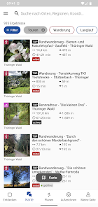
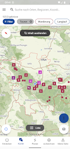
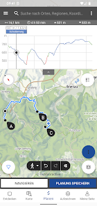
About the app: All tours and trail networks are listed on an interactive map. In addition to hiking trails, descriptions and information on how to get there, you will find useful details on the locations of refuges, accommodation and restaurants. The app is a perfect companion through the regions of the Thuringian Forest and offers you the opportunity to plan individual tours as well as suggested routes.
APP FEATURES:
- individual tour planner
- Navigation
- Information about tourist offers
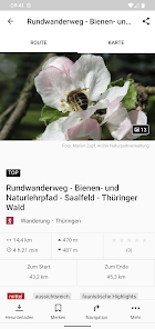
- Tour suggestions including: length, duration, difficulty, elevation profile, arrival and parking options, path conditions and sights along the route
OUTDOOR ON THE ROAD – YOUR OPTIONS:
- Hiking (Rennsteig with tips on vantage points and regional culinary highlights; certified hiking trails such as the Schwarzatal panorama trail, summit hiking trail, Hohenwarte Stausee trail, etc.)
- Cycling (pleasure cycling, MTB, racing bike; bike tours on and off the Rennsteig; pleasure cycling along rivers)
- Skiing (DSV nordic active centers along the Rennsteig; Rennsteig ski trail)
- Water hiking (water sports on the Thuringian Sea, Werra and Saale)
Note on GPS use:
Using the app in the background with GPS tracking enabled may decrease battery life. For the longest possible battery life, we therefore recommend that you close the app when you are not using it.
Are you ready to actively discover the Thuringian Forest? The THÜRINGER FOREST APP has everything you need: great hiking and cycling routes, information about water sports in summer and skiing adventures in winter. In addition to tour tips and directions, there is insider knowledge about sights, places to stop for refreshments and accommodation.
Welcome to one of the most beautiful low mountain ranges in Germany - promising peaks, green valleys, protected high moors and mountain meadows, and of course the endless expanses of deep forests await you. No matter whether you are looking for sporting challenges or like moments of relaxation in nature: with both you are in the right place in the Thuringian Forest. The Rennsteig is the oldest and best-known German long-distance hiking trail - cult and myth at the same time. Even away from the ridge path, you will be surprised by numerous quality hiking trails and ADFC-certified bike routes. Glittering reservoirs and rushing rivers make your heart beat faster? Then enjoy the Thuringian Forest with stand-up paddling (SUP), packrafting, on a kayak or canoe tour, climbing or skiing - there are no limits to active relaxation.
About the app: All tours and trail networks are listed on an interactive map. In addition to hiking trails, descriptions and information on how to get there, you will find useful details on the locations of refuges, accommodation and restaurants. The app is a perfect companion through the regions of the Thuringian Forest and offers you the opportunity to plan individual tours as well as suggested routes.
APP FEATURES:
- individual tour planner
- Navigation
- Information about tourist offers
- Tour suggestions including: length, duration, difficulty, elevation profile, arrival and parking options, path conditions and sights along the route
OUTDOOR ON THE ROAD – YOUR OPTIONS:
- Hiking (Rennsteig with tips on vantage points and regional culinary highlights; certified hiking trails such as the Schwarzatal panorama trail, summit hiking trail, Hohenwarte Stausee trail, etc.)
- Cycling (pleasure cycling, MTB, racing bike; bike tours on and off the Rennsteig; pleasure cycling along rivers)
- Skiing (DSV nordic active centers along the Rennsteig; Rennsteig ski trail)
- Water hiking (water sports on the Thuringian Sea, Werra and Saale)
Note on GPS use:
Using the app in the background with GPS tracking enabled may decrease battery life. For the longest possible battery life, we therefore recommend that you close the app when you are not using it.
Updated on
Safety starts with understanding how developers collect and share your data. Data privacy and security practices may vary based on your use, region and age The developer provided this information and may update it over time.


Ratings and reviews
4.1
51 reviews
What's new
bug fixes


