
JARVIS GPS Monitor

4.4star
418 reviews

Everyone
info
5K+
Downloads

Everyone
Learn more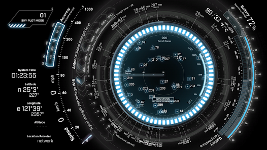

About this app
JARVIS GPS Monitor is a professional GNSS monitoring tool that provides real-time visualization of satellite positioning data on your Android device.
Multi-Constellation Support
Track satellites from all major navigation systems simultaneously:
GPS, GLONASS, BeiDou, Galileo, QZSS, IRNSS/NavIC, and SBAS.
Sky Plot
View satellites overhead in a real-time polar sky chart showing azimuth, elevation, and signal strength for each visible satellite.
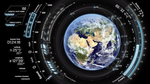
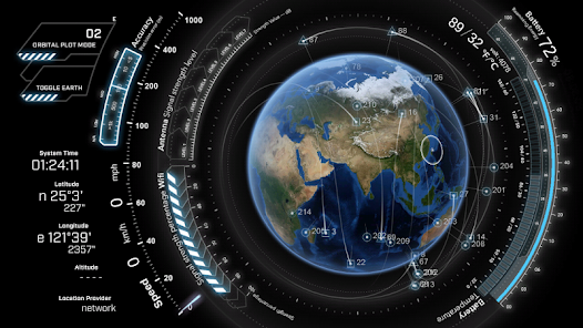
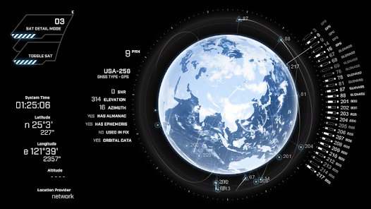
Orbit Visualization
Explore satellite orbits in both 3D and 2D views with real orbital data powered by NORAD TLE propagation, updated automatically.
Signal Analysis
Monitor carrier-to-noise ratio (SNR) for every tracked satellite. Identify weak signals and compare performance across constellations.
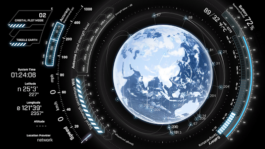
Map & Trajectory
OpenStreetMap-based map with real-time position tracking and trajectory visualization. See your path drawn on the map as you move.
Navigation Dashboard
At a glance, view your compass heading, speed, positioning accuracy, antenna signal strength, battery level, and connectivity status.
Perfect for GNSS professionals, navigation enthusiasts, surveyors, and anyone who wants a deeper look into how satellite positioning works on their device.
Multi-Constellation Support
Track satellites from all major navigation systems simultaneously:
GPS, GLONASS, BeiDou, Galileo, QZSS, IRNSS/NavIC, and SBAS.
Sky Plot
View satellites overhead in a real-time polar sky chart showing azimuth, elevation, and signal strength for each visible satellite.
Orbit Visualization
Explore satellite orbits in both 3D and 2D views with real orbital data powered by NORAD TLE propagation, updated automatically.
Signal Analysis
Monitor carrier-to-noise ratio (SNR) for every tracked satellite. Identify weak signals and compare performance across constellations.
Map & Trajectory
OpenStreetMap-based map with real-time position tracking and trajectory visualization. See your path drawn on the map as you move.
Navigation Dashboard
At a glance, view your compass heading, speed, positioning accuracy, antenna signal strength, battery level, and connectivity status.
Perfect for GNSS professionals, navigation enthusiasts, surveyors, and anyone who wants a deeper look into how satellite positioning works on their device.
Updated on
Safety starts with understanding how developers collect and share your data. Data privacy and security practices may vary based on your use, region, and age. The developer provided this information and may update it over time.

No data shared with third parties
Learn more about how developers declare sharing

No data collected
Learn more about how developers declare collection

Data is encrypted in transit

Data can’t be deleted
Ratings and reviews
4.4
389 reviews

VIRAL PARMAR
- Flag inappropriate
February 19, 2026
I can't use two fingers to navigate in route plot mode . just add on the destination feature if possible. it helps alot

Mike Morris
- Flag inappropriate
May 20, 2022
To put it bluntly, it's a toy. Now don't get me wrong, it's a BAD A$$ TOY! It would be worthy of 5⭐⭐⭐⭐⭐'s if you had more control options. Example 1: Be able to pre-map your route. Example 2: Switch between km/h and mp/h. Example 3: A detailed sat-map and route map. If there was an app launcher (Not a Theme) with this with this type of interface, I would probably consider tossing my current one. And it's a premium Visionary app launcher Pro and app lock with a futuristic design.
38 people found this review helpful

A Google user
- Flag inappropriate
April 13, 2020
Amazing interface but NEEDS A SEARCH OPTION FOR GPS NAVIGATION!!!!!! ALSO when you get to the maps area, there is this cool white pulse just before showing your surroundings. I'd say make an update to where that pulse happens every 5 or 10 seconds!! Please update soon:)
29 people found this review helpful
What’s new
1. Added issue reporting — when a map tile fails to load, you can choose to send a diagnostic report to help us fix the problem faster
2. Added an additional elevation data source and adjusted map data download strategy
3. Fixed touch input issues
2. Added an additional elevation data source and adjusted map data download strategy
3. Fixed touch input issues
Everyone
Learn moreApp support
About the developer
芬達實驗室
service@phardera.com
320068台湾桃園市中壢區
中福路222號
+886 910 802 818


