
PPGpS

4.1star
591 opiniones
10 k+
Descargas

Apto para todo público
info


Acerca de esta app
Welcome to PPGpS, a Flight Computer for Paramotor, Paraglider, Glider and Ultra Light plane Pilots.
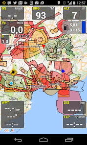
-Airspaces display
-PPGpS can now display an Airspace overlay on the map.
It is using OpenAir files that can be downloaded from the net and copied in the \PPGpS\airspaces folder.
You may also use the AirspaceMap app to help you download some OpenAir files from various sources easily, and customize these large airspace maps to fit your needs,
and then export them to the PPGpS airspace folder.
*FEATURES OVERVIEW:
-Real time flight information
-Wind direction and speed estimation
-Takeoff and Landing phases auto-detection
-Return home information (display estimated travel time and bearing)
-Fuel calculation and warning
-Airspace display (OpenAir files)
-Emergency geo-localized SMS
-Barometric sensor support to improve altitude accuracy
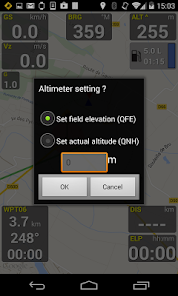
-QHN, QFE Altimeter setting
-Online and offline maps
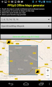
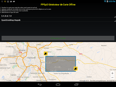
-Offline maps creator
-Google Maps and OpenStreetMap map providers
-Rotating Map
-Log flights in KML (for Google Earth), IGC (Leonardo servers) and GPX files
-Replay recorded flights
-Waypoint management
-Especially developed for Paramotor
-Embedded User Manual and Tip of the day feature.
-Real time flight tracking on www.ppgps.info
-Variometer
-Sunset time
-FlyNet2, Flight Bandit, BlueFlyVario and LK8Ex1 variometer support
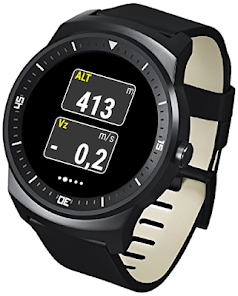
-Android Wear SmartWatch support with PPGpS Wear
*MAPS:
Online:
PPGpS can display Google or OpenStreetMap maps in connected mode.
Offline:
Download map files in your smartphone in case you don't have an internet connection during the flight.
Use the integrated PPGpS Offline Map Creator to generate offline maps.
*INSTRUMENTS:
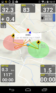
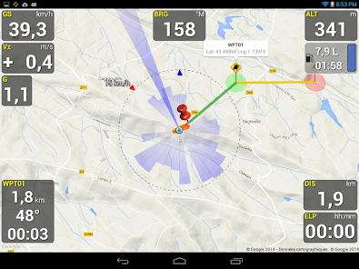
PPGpS provides the altitude, vario, bearing, magnetic compass, acceleration and ground speed.
With just one click on instruments you switch easily between different data modes : instantaneous, average and maximum values.
Altimeter can be set to actual altitude or elevation (QHN, QFE) just by long-pressing on the altimeter.
If your smartphone has a barometric sensor, it could be used to compute a very accurate altitude.
You can use PPGpS Wear companion application to display your instruments on your SmartWatch.
*WAYPOINTS:
Create waypoints by tapping on the map or by entering their GPS coordinates.
Select a waypoint with one click on the waypoint instrument (WPT).
Rename or remove a waypoint from the contextual menu of the waypoint list.
Follow the displayed route (bearing, estimated travel time and distance).
Prepare your waypoints from Google Earth and import your KML files (PPGpS folder in the phone).
Waypoints may be automatically loaded at startup and saved at the end of the session.
In case your KML file doesn't import well, please send me the file and I will fix it quickly.
*WIND AND SPEEDS HUD:
The average ground speeds are graphically displayed for every azimuth.
The wind direction is displayed (red arrow) and may be reset at any time during the flight.
*RETURN HOME:
Home direction and Estimated Travel Time to return home is always displayed (shaded red line).
Computations are done according to the wind for accurate results.
*LIVE TRACKING:
Enable the Live Tracking feature to allow your friends and family to see you live on map ! Go to www.ppgps.info for more details.
*AIRSPACE:
Copy OpenAir files in the /ppgps/airspace folder to display airspaces on top of the map
Use my other app AirspaceMap to help you download and customize your openAir files
https://play.google.com/store/apps/details?id=com.ns31.airspacemap
Launch the Demonstration mode to have a quick tour.
Visit http://www.ppgps.info
Find us on Facebook : https://www.facebook.com/ppgps
and Twitter : https://twitter.com/PPGpSAndroid
Enjoy your flights with PPGpS and thank you for your feedback.
stephane.nicole31@gmail.com
-Airspaces display
-PPGpS can now display an Airspace overlay on the map.
It is using OpenAir files that can be downloaded from the net and copied in the \PPGpS\airspaces folder.
You may also use the AirspaceMap app to help you download some OpenAir files from various sources easily, and customize these large airspace maps to fit your needs,
and then export them to the PPGpS airspace folder.
*FEATURES OVERVIEW:
-Real time flight information
-Wind direction and speed estimation
-Takeoff and Landing phases auto-detection
-Return home information (display estimated travel time and bearing)
-Fuel calculation and warning
-Airspace display (OpenAir files)
-Emergency geo-localized SMS
-Barometric sensor support to improve altitude accuracy
-QHN, QFE Altimeter setting
-Online and offline maps
-Offline maps creator
-Google Maps and OpenStreetMap map providers
-Rotating Map
-Log flights in KML (for Google Earth), IGC (Leonardo servers) and GPX files
-Replay recorded flights
-Waypoint management
-Especially developed for Paramotor
-Embedded User Manual and Tip of the day feature.
-Real time flight tracking on www.ppgps.info
-Variometer
-Sunset time
-FlyNet2, Flight Bandit, BlueFlyVario and LK8Ex1 variometer support
-Android Wear SmartWatch support with PPGpS Wear
*MAPS:
Online:
PPGpS can display Google or OpenStreetMap maps in connected mode.
Offline:
Download map files in your smartphone in case you don't have an internet connection during the flight.
Use the integrated PPGpS Offline Map Creator to generate offline maps.
*INSTRUMENTS:
PPGpS provides the altitude, vario, bearing, magnetic compass, acceleration and ground speed.
With just one click on instruments you switch easily between different data modes : instantaneous, average and maximum values.
Altimeter can be set to actual altitude or elevation (QHN, QFE) just by long-pressing on the altimeter.
If your smartphone has a barometric sensor, it could be used to compute a very accurate altitude.
You can use PPGpS Wear companion application to display your instruments on your SmartWatch.
*WAYPOINTS:
Create waypoints by tapping on the map or by entering their GPS coordinates.
Select a waypoint with one click on the waypoint instrument (WPT).
Rename or remove a waypoint from the contextual menu of the waypoint list.
Follow the displayed route (bearing, estimated travel time and distance).
Prepare your waypoints from Google Earth and import your KML files (PPGpS folder in the phone).
Waypoints may be automatically loaded at startup and saved at the end of the session.
In case your KML file doesn't import well, please send me the file and I will fix it quickly.
*WIND AND SPEEDS HUD:
The average ground speeds are graphically displayed for every azimuth.
The wind direction is displayed (red arrow) and may be reset at any time during the flight.
*RETURN HOME:
Home direction and Estimated Travel Time to return home is always displayed (shaded red line).
Computations are done according to the wind for accurate results.
*LIVE TRACKING:
Enable the Live Tracking feature to allow your friends and family to see you live on map ! Go to www.ppgps.info for more details.
*AIRSPACE:
Copy OpenAir files in the /ppgps/airspace folder to display airspaces on top of the map
Use my other app AirspaceMap to help you download and customize your openAir files
https://play.google.com/store/apps/details?id=com.ns31.airspacemap
Launch the Demonstration mode to have a quick tour.
Visit http://www.ppgps.info
Find us on Facebook : https://www.facebook.com/ppgps
and Twitter : https://twitter.com/PPGpSAndroid
Enjoy your flights with PPGpS and thank you for your feedback.
stephane.nicole31@gmail.com
Actualización
El primer paso de la seguridad es comprender cómo los desarrolladores recopilan y comparten tus datos. Las prácticas de privacidad y seguridad de datos pueden variar en función del uso de la app, la región y la edad. El desarrollador proporcionó esta información y podría actualizarla con el tiempo.

No se comparten datos con terceros
Más información sobre cómo los desarrolladores declaran el uso compartido

No se recopilan datos
Más información sobre cómo los desarrolladores declaran la recopilación
Calificaciones y opiniones
4.1
565 opiniones

Román Quintana
- Marcar como inapropiada
28 de mayo de 2020
Yo le añadiria el L/D coeficiente de planeo, por lo demas, es Sencillo, y más que suficiente para la práctica del paramotor. Muy práctica la estimación del consumo(mejor estimar más consumo) los mapas, el cálculo del viento, el variometro el altimetro, los mapas de espacios aéreos, el rumbo, y la puesta de sol para saber el tiempo que que queda de luz
Esta opinión les resultó útil a 3 personas

Jose Mª Fernandez
- Marcar como inapropiada
25 de julio de 2021
Magnífica app, llevo tiempo con ella al principio bien después hubo una versión que se quedaba colgada, pero me puse en contacto con el desarrollador y en la siguiente versión lo reparo y por ahora en la última v1. 59a va todo perfectamente.
Esta opinión les resultó útil a 2 personas

Xavi carlos criado alberich
- Marcar como inapropiada
20 de febrero de 2021
Muy buena aplicación pero la última versión se queda colgada al rato de estar volando. No descargar o actualizar hasta que este solucionado. No entiendo como no se prueba bien antes de que actualicen la nueva versión. Por eso valoro con solo 1 estrella
Esta opinión les resultó útil a 2 personas
Novedades
1.59a 05/2021
Support generic LK8Ex1 protocol for bluetooth altivarios
Timestamps in KML track files for better replay
Bug fix on Replay
Bug fix on Tip of the day
1.58 04/2021
Italian translation completed
Airspace file parsing improved
File security issue with Android 11 fixed
1.57 04/2021
Input Map and Waypoint name fixed
Elevation above ground crash fix
1.56 09/2020
Floating text color configurable
Lock the screen in portrait, landscape and inverted