
My Elevation
Sadržava oglase
4,7star
22,7 hilj. recenzija
1 mil.+
Preuzimanja

Svako
info


O aplikaciji
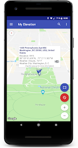
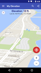
My Elevation uses web services to get your precise surface elevation based on your current location. This is far more accurate than the elevation data provided by your device. But there's so much more you can do with My Elevation. Try it and see!
Notes:
● The application shows the surface elevation above sea level based a latitude and longitude. It does not provide altitude in cases where you are in an aircraft, high up in a building, or high off of ground for some reason.
● This application must have a working data connection to be able to show your position on the map, get your precise elevation and provide much additional rich content . It does not have an off line mode. Please consider this before giving poor ratings when it doesn't work when you have no data connection.
Feature List
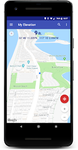
● Follow Me Mode - Follows your current location in real time. Watch your movements on a map and see your elevation and coordinates updating as you move.
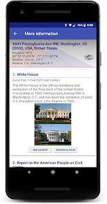
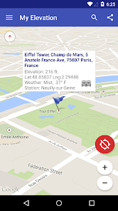
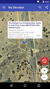
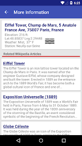
● Search for Locations and watch the map fly over to them. My Elevation will tell you the weather there and let you browse Wikipedia articles about attractions nearby the location. If you are curious at all about other places you will love this !
● Long press a location on the map and My Elevation will tell you the weather there and let you browse Wikipedia articles about attractions nearby the location.
● Add bookmarks for places you want to remember.
● Share your location or what you find in searches with your friends in a text or email.
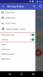
Display Options
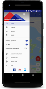
Map Mode - Lets you pick one of four Google Map types (Normal, Satellite, Topo and Hybrid)
Heading Up, Map Tilt and Night Mode
Try it out and let us know how it goes.
email us at rdhsoftware@gmail.com
or visit https://www.facebook.com/MyElevation
This application uses Google Analytics to collect anonymous data about how the application is used and what failures occur. This allows us to make the application better with each release. You can opt out of this by un-checking the Analytics data item in the application preferences. No personally identifying information is collected.
Notes:
● The application shows the surface elevation above sea level based a latitude and longitude. It does not provide altitude in cases where you are in an aircraft, high up in a building, or high off of ground for some reason.
● This application must have a working data connection to be able to show your position on the map, get your precise elevation and provide much additional rich content . It does not have an off line mode. Please consider this before giving poor ratings when it doesn't work when you have no data connection.
Feature List
● Follow Me Mode - Follows your current location in real time. Watch your movements on a map and see your elevation and coordinates updating as you move.
● Search for Locations and watch the map fly over to them. My Elevation will tell you the weather there and let you browse Wikipedia articles about attractions nearby the location. If you are curious at all about other places you will love this !
● Long press a location on the map and My Elevation will tell you the weather there and let you browse Wikipedia articles about attractions nearby the location.
● Add bookmarks for places you want to remember.
● Share your location or what you find in searches with your friends in a text or email.
Display Options
Map Mode - Lets you pick one of four Google Map types (Normal, Satellite, Topo and Hybrid)
Heading Up, Map Tilt and Night Mode
Try it out and let us know how it goes.
email us at rdhsoftware@gmail.com
or visit https://www.facebook.com/MyElevation
This application uses Google Analytics to collect anonymous data about how the application is used and what failures occur. This allows us to make the application better with each release. You can opt out of this by un-checking the Analytics data item in the application preferences. No personally identifying information is collected.
Ažurirano dana
Sigurnost počinje razumijevanjem na koji način programeri prikupljaju i dijele vaše podatke. Privatnost podataka i sigurnosne prakse se mogu razlikovati ovisno o korištenju, regiji i dobi. Programer je pružio ove informacije i može ih s vremenom ažurirati.


Ocjene i recenzije
4,7
22,2 hilj. recenzija

Googleov korisnik
- Označavanje kao neprikladno
3. april 2020.
Ok

alicadil
- Označavanje kao neprikladno
26. januar 2024.
ok
Šta ima novo
New search providers.
Library updates and bug fixes.
Library updates and bug fixes.


