RIDGID Trax
3.8star
29ଟି ସମୀକ୍ଷା
5ହ+
ଡାଉନଲୋଡଗୁଡ଼ିକ

ସମସ୍ତେ
info


ଏହି ଆପ୍ ବିଷୟରେ
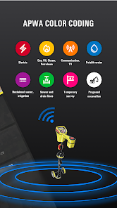
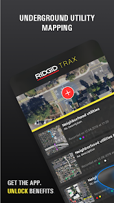
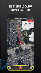
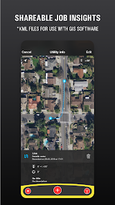
RIDGID Trax is a tool that allows for basic underground utility mapping in real-time. By wirelessly connecting a mobile device via Bluetooth to a RIDGID SR-24 Utility Locator, RIDGID Trax can provide the GPS position and depth of the target utility. Not only can you identify the type of utility, such as water, gas, or electric, but multiple utilities can also be displayed on the same map. Additionally, a finished map can be saved and viewed within the app, or exported to a *.KML file which can be used with popular GIS programs.
ଗତ ଅପଡେଟର ସମୟ
ଡେଭେଲପରମାନେ ଆପଣଙ୍କ ଡାଟାକୁ କିପରି ସଂଗ୍ରହ ଏବଂ ସେୟାର କରନ୍ତି ସେହି ଧାରଣା ସହିତ ସୁରକ୍ଷା ଆରମ୍ଭ ହୁଏ। ଆପଣଙ୍କ ବ୍ୟବହାର, ଅଞ୍ଚଳ ଏବଂ ବୟସ ଆଧାରରେ, ଡାଟା ଗୋପନୀୟତା ଓ ସୁରକ୍ଷା କାର୍ଯ୍ୟପଦ୍ଧତିଗୁଡ଼ିକ ଭିନ୍ନ ହୋଇପାରେ। ଡେଭେଲପର ଏହି ସୂଚନା ପ୍ରଦାନ କରିଛନ୍ତି ଏବଂ ସେ ସମୟାନୁସାରେ ଏହାକୁ ଅପଡେଟ କରିପାରନ୍ତି।

ତୃତୀୟ ପକ୍ଷଗୁଡ଼ିକ ସହ କୌଣସି ଡାଟା ସେୟାର କରାଯାଇନାହିଁ
ଡେଭେଲପରମାନେ କିପରି ସେୟାରିଂର ଘୋଷଣା କରନ୍ତି ସେ ବିଷୟରେ ଅଧିକ ଜାଣନ୍ତୁ

ଏହି ଆପ ଏଇ ଡାଟା ପ୍ରକାରଗୁଡ଼ିକ ସଂଗ୍ରହ କରିପାରେ
ଲୋକେସନ, ଆପ କାର୍ଯ୍ୟକଳାପ ଏବଂ ଅନ୍ୟ 2ଟି

ଟ୍ରାଞ୍ଜିଟ ସମୟରେ ଡାଟା ଏନକ୍ରିପ୍ଟ କରାଯାଇଥାଏ

ଡାଟା ଡିଲିଟ କରାଯାଇପାରିବ ନାହିଁ
ମୂଲ୍ୟାଙ୍କନ ଓ ସମୀକ୍ଷା
3.8
27ଟି ସମୀକ୍ଷା
ନୂଆ କଣ ଅଛି
Bug fixes and stability improvement.


