
Hunting Gps Maps w/ Property L
Ilova ichida xaridlar
3,6star
607 ta sharh
100 ming+
Yuklanmalar

Hamma uchun
info


Bu ilova haqida
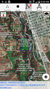
This hunting GPS app provides access to property line maps, parcels & public
lands, land ownership details. Map layers for 50+ states include hunting
zones, restricted areas, possible access areas, state refgues and more.
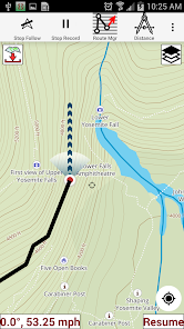
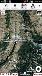
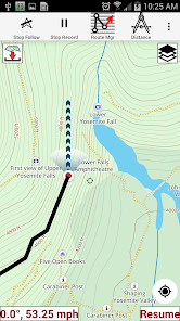
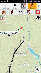
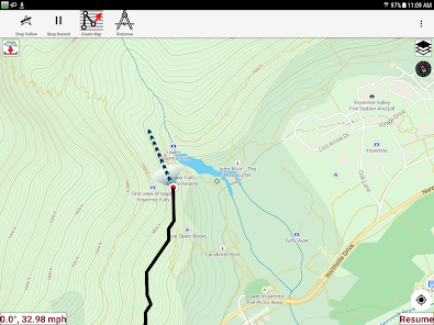
Vector topo maps with most accurate USGS elevation contours, hiking & biking
trails. Coverage includes all US states.
► Vector Topo Maps
√ Beautiful & detailed Hardware/GPU accelerated vector maps (text stays upright on rotation)
√ Vector USGS contours (Change height to ft or meter).
√ Covers popular hiking & biking trails and paths
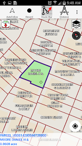
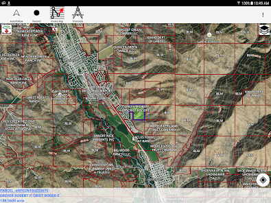
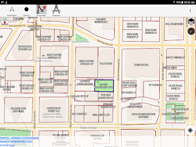
► Parcel Maps
√ Includes following ownerhsip attributes (where available)
* Owner name and Owner address
* Site Address
* Parcel ID Total Value
► Hunt Planning maps
√ Possible Public Access
√ Public lands and Parcels
√ Hunting Zones
√ Game Distribution
√ Restricted Ares
√ Portions
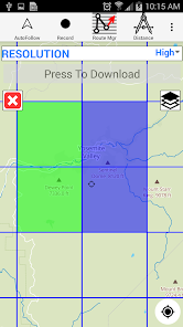
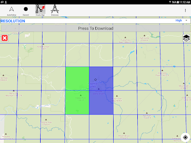
► Offline vector maps
√ Easy to download offline topos
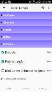
► PLSS maps
√ PLSS Townships and Sections (US Wide coverage)
► Custom base maps
√ Switch base maps between vector topos, hybrid satellite imagery and more
►GPS FEATURES
√ Record Tracks
√ Enter or import Waypoints.
√ Auto Follow
* Real Time Track Overlay
* Predicted Path Vector
* Course Up(Text stays upright)
* Speed & Heading
√ Route Assistance With Voice Prompts
* Prompts when approaching a boating route marker
* Continous distance & ETA updates
* Alerts when off route
* Alerts when moving in wrong direction
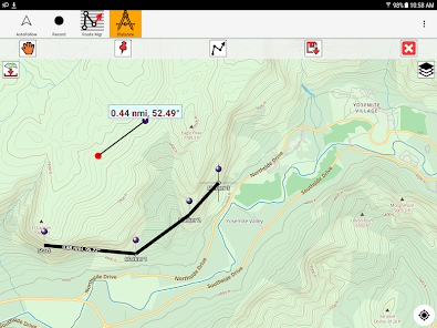
►ROUTE MANAGEMENT / TRIP PLANNING
√ Create New Route/Edit Existing Routes
√ Move Points
√ Add points to an existing route leg
√ Delete / Rename points
√ Import GPX,KML & KMZ files
√ Plot/Edit Routes
√ Enter Waypoints
√ Share/Export Routes,Tracks&Markers
√ Reverse Routes
► SHARING
* Share tracks/routes/markers on Facebook & Twitter
* Export tracks/routes/markers as compressed GPX files.
► Topo & Trail Maps for National Parks
Detailed topographic trail maps are included for national and state park including::
√ Great Smoky Mountains
√ Grand Canyon
√ Zion
√ Rocky Mountain
√ Yosemite
√ Yellowstone
√ Acadia
√ Olympic
√ Denali
√ Glacier
► Suggested Uses for i-Hunting Topo Maps
√ Hunt Planning & Recon
√ Off trail and On trail hiking
√ Backpacking : Use Topos of National Forests and Wilderness areas with GPS
√ Snow Sports (Snow Shoeing, Skiing, Snowboarding, Snow Mobiling)
√ SAR (Search and Rescue)
The i-Hunting application can turn your phone into full fledged outdoors GPS unit (like Garmin ® or Magellan ® outddor GPS). The app compliments the gear you got from Dick's ® , REI ® , Cabelas ® etc.
lands, land ownership details. Map layers for 50+ states include hunting
zones, restricted areas, possible access areas, state refgues and more.
Vector topo maps with most accurate USGS elevation contours, hiking & biking
trails. Coverage includes all US states.
► Vector Topo Maps
√ Beautiful & detailed Hardware/GPU accelerated vector maps (text stays upright on rotation)
√ Vector USGS contours (Change height to ft or meter).
√ Covers popular hiking & biking trails and paths
► Parcel Maps
√ Includes following ownerhsip attributes (where available)
* Owner name and Owner address
* Site Address
* Parcel ID Total Value
► Hunt Planning maps
√ Possible Public Access
√ Public lands and Parcels
√ Hunting Zones
√ Game Distribution
√ Restricted Ares
√ Portions
► Offline vector maps
√ Easy to download offline topos
► PLSS maps
√ PLSS Townships and Sections (US Wide coverage)
► Custom base maps
√ Switch base maps between vector topos, hybrid satellite imagery and more
►GPS FEATURES
√ Record Tracks
√ Enter or import Waypoints.
√ Auto Follow
* Real Time Track Overlay
* Predicted Path Vector
* Course Up(Text stays upright)
* Speed & Heading
√ Route Assistance With Voice Prompts
* Prompts when approaching a boating route marker
* Continous distance & ETA updates
* Alerts when off route
* Alerts when moving in wrong direction
►ROUTE MANAGEMENT / TRIP PLANNING
√ Create New Route/Edit Existing Routes
√ Move Points
√ Add points to an existing route leg
√ Delete / Rename points
√ Import GPX,KML & KMZ files
√ Plot/Edit Routes
√ Enter Waypoints
√ Share/Export Routes,Tracks&Markers
√ Reverse Routes
► SHARING
* Share tracks/routes/markers on Facebook & Twitter
* Export tracks/routes/markers as compressed GPX files.
► Topo & Trail Maps for National Parks
Detailed topographic trail maps are included for national and state park including::
√ Great Smoky Mountains
√ Grand Canyon
√ Zion
√ Rocky Mountain
√ Yosemite
√ Yellowstone
√ Acadia
√ Olympic
√ Denali
√ Glacier
► Suggested Uses for i-Hunting Topo Maps
√ Hunt Planning & Recon
√ Off trail and On trail hiking
√ Backpacking : Use Topos of National Forests and Wilderness areas with GPS
√ Snow Sports (Snow Shoeing, Skiing, Snowboarding, Snow Mobiling)
√ SAR (Search and Rescue)
The i-Hunting application can turn your phone into full fledged outdoors GPS unit (like Garmin ® or Magellan ® outddor GPS). The app compliments the gear you got from Dick's ® , REI ® , Cabelas ® etc.
Oxirgi yangilanish
Xavfsizlik — dastur ishlab chiquvchilar maʼlumotlaringizni qanday jamlashi va ulashishini tushinishdan boshlanadi. Maʼlumotlar maxfiyligi va xavfsizlik amaliyotlari ilovadan foydalanish, hudud va yoshga qarab farq qilishi mumkin. Bu axborot dastur ishlab chiquvchi tomonidan taqdim etilgan va keyinchalik yangilanishi mumkin.

Tashqi hamkorlarga hech qanday axborot ulashilmagan
Dastur ishlab chiquvchilar axborot ulashilishini qanday aytishi haqida batafsil

Ushbu ilova quyidagi axborot turlarini toʻplashi mumkin
Joylashuv va Men haqimda

Maʼlumotlar uzatish vaqtida shifrlanadi

Maʼlumotlarni oʻchirishni soʻrashingiz mumkin
Reytinglar va sharhlar
3,6
586 ta sharh
Nima yangiliklar
- GPS related fixes for latest Android versions.
- 64 bit ARM support
- Scoped Storage Support
- 64 bit ARM support
- Scoped Storage Support


