
Tactical NAV: MGRS Navigation
In-app purchases

3.9star
111 reviews
5K+
Downloads

Everyone
info


About this app
Created on a combat deployment to Afghanistan during Operation Enduring Freedom (OEF), Tactical NAV was the first MGRS-focused navigation app available on all app stores.
BACKGROUND:
Built from the ground up in the rugged mountains of eastern Afghanistan, Tactical NAV was created by a U.S. Army Field Artillery officer with the vision of crafting a low-cost and highly accurate mobile navigation platform tailored for the U.S. military.
Tactical NAV's journey began in the Pech River Valley and the Korengal Valley in Kunar Province, Afghanistan.
U.S. Army Capt. Jonathan J. Springer, a Fire Support Officer with the 101st Airborne Division (Air Assault), embarked on the development of this tactical navigation platform immediately following the memorial services for Spc. Blair D. Thompson and Spc. Jared C. Plunk, who were killed in action on June 25, 2010.
Despite initial rejections by the Department of Defense, Captain Springer remained steadfast in his mission to continue developing Tactical NAV — even to this day. His ultimate goals were (and still are) to make a positive difference for other soldiers and service members and to honor the men and women killed and wounded in battle.
He used his life savings to fund and develop Tactical NAV, all with the ultimate hope of saving military lives and assisting fellow service members in accomplishing their missions at home and abroad.
Tactical NAV officially launched on the App Store and Google Play on February 14, 2011.
BUILT FOR ACCURACY:
Tactical NAV's performance accurately matches that of the AN/PSN-13 Defense Advanced GPS Receiver (DAGR).
MISSION:
Empower military service members with a highly accurate and powerful mobile navigation platform.
VISION:
Assist and support our nation's service members with their mobile navigational needs and enable them to operate and win in both training and combat environments.
BOTTOM LINE:
Tactical NAV has successfully undergone evaluation against other software platforms and devices such as Nett Warrior, ATAK, and BFT. Its accuracy is within 1 meter of these officially approved systems issued by the DoD.
IAPs & SUBSCRIPTIONS:
Tactical NAV offers in-app purchases (IAPs) and subscriptions. Currently, tactical drawing mode is available as an in-app purchase, and offline mapping mode is also accessible to users as either a monthly or yearly subscription.
All revenue generated from these features contributes to further developmental coding and updates, and a portion of the proceeds are donated to charities that specifically benefit disabled veterans.
KEY FEATURES:
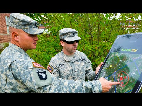
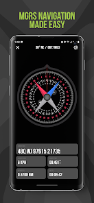
• A military-quality precision targeting platform
• Purpose-built for the individual Soldier
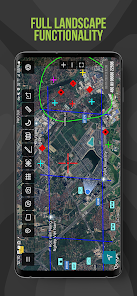
• Offline mapping capabilities (complete usage of the app with no emission of a cellular signal)
• WGS-84 standard (MGRS, UTM, BNG, and USNG coordinates)
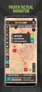
• Tactical drawing mode (useful for mission planning, building overlays, targeting, etc.)
• Waypoint plotting functionality with military graphics (per FM 1-02.2)
• Compass "FastLock" function for capturing quick and precise azimuths
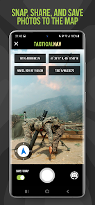
• Snap and save photographs onto the main map to increase situational awareness
• Location, waypoint, and photo-sharing capabilities (via email and text)
• One-button night mode function for low-light situations
• 'Go to Grid' feature for precision planning, drawing of overlays, and dropping waypoints
• Rigorously tested to ensure utmost accuracy and reliability
• Android native code built for austere and contested environments
IMPORTANT NOTES:
The Department of Defense does not endorse Tactical NAV, nor should it be used in life-threatening or combat situations in place of a government-issued device.
OFFLINE MAPS TUTORIAL:
Learn more about offline maps and other features through our YouTube tutorial. Follow this link to view the video walkthrough: https://bit.ly/Offline-Maps
SUPPORT:
If you have any questions about the app, please contact Jonathan Springer directly at jon@tacticalnav.com.
BACKGROUND:
Built from the ground up in the rugged mountains of eastern Afghanistan, Tactical NAV was created by a U.S. Army Field Artillery officer with the vision of crafting a low-cost and highly accurate mobile navigation platform tailored for the U.S. military.
Tactical NAV's journey began in the Pech River Valley and the Korengal Valley in Kunar Province, Afghanistan.
U.S. Army Capt. Jonathan J. Springer, a Fire Support Officer with the 101st Airborne Division (Air Assault), embarked on the development of this tactical navigation platform immediately following the memorial services for Spc. Blair D. Thompson and Spc. Jared C. Plunk, who were killed in action on June 25, 2010.
Despite initial rejections by the Department of Defense, Captain Springer remained steadfast in his mission to continue developing Tactical NAV — even to this day. His ultimate goals were (and still are) to make a positive difference for other soldiers and service members and to honor the men and women killed and wounded in battle.
He used his life savings to fund and develop Tactical NAV, all with the ultimate hope of saving military lives and assisting fellow service members in accomplishing their missions at home and abroad.
Tactical NAV officially launched on the App Store and Google Play on February 14, 2011.
BUILT FOR ACCURACY:
Tactical NAV's performance accurately matches that of the AN/PSN-13 Defense Advanced GPS Receiver (DAGR).
MISSION:
Empower military service members with a highly accurate and powerful mobile navigation platform.
VISION:
Assist and support our nation's service members with their mobile navigational needs and enable them to operate and win in both training and combat environments.
BOTTOM LINE:
Tactical NAV has successfully undergone evaluation against other software platforms and devices such as Nett Warrior, ATAK, and BFT. Its accuracy is within 1 meter of these officially approved systems issued by the DoD.
IAPs & SUBSCRIPTIONS:
Tactical NAV offers in-app purchases (IAPs) and subscriptions. Currently, tactical drawing mode is available as an in-app purchase, and offline mapping mode is also accessible to users as either a monthly or yearly subscription.
All revenue generated from these features contributes to further developmental coding and updates, and a portion of the proceeds are donated to charities that specifically benefit disabled veterans.
KEY FEATURES:
• A military-quality precision targeting platform
• Purpose-built for the individual Soldier
• Offline mapping capabilities (complete usage of the app with no emission of a cellular signal)
• WGS-84 standard (MGRS, UTM, BNG, and USNG coordinates)
• Tactical drawing mode (useful for mission planning, building overlays, targeting, etc.)
• Waypoint plotting functionality with military graphics (per FM 1-02.2)
• Compass "FastLock" function for capturing quick and precise azimuths
• Snap and save photographs onto the main map to increase situational awareness
• Location, waypoint, and photo-sharing capabilities (via email and text)
• One-button night mode function for low-light situations
• 'Go to Grid' feature for precision planning, drawing of overlays, and dropping waypoints
• Rigorously tested to ensure utmost accuracy and reliability
• Android native code built for austere and contested environments
IMPORTANT NOTES:
The Department of Defense does not endorse Tactical NAV, nor should it be used in life-threatening or combat situations in place of a government-issued device.
OFFLINE MAPS TUTORIAL:
Learn more about offline maps and other features through our YouTube tutorial. Follow this link to view the video walkthrough: https://bit.ly/Offline-Maps
SUPPORT:
If you have any questions about the app, please contact Jonathan Springer directly at jon@tacticalnav.com.
Updated on
Safety starts with understanding how developers collect and share your data. Data privacy and security practices may vary based on your use, region, and age. The developer provided this information and may update it over time.

No data shared with third parties
Learn more about how developers declare sharing

No data collected
Learn more about how developers declare collection
Ratings and reviews
4.0
106 reviews

R. Raider
- Flag inappropriate
- Show review history
May 5, 2024
Captain Springer is awesome and incredibly helpful when I had questions about Tactical NAV. He's created the best tactical app outside of ATAK, and that's really saying something. Looking forward to future updates, and happy to support someone who gives back to our disabled veterans. Also I wanted to add that that the drawing abilities and offline maps are a game changer for me. I can build all my overlays without a cellular connection, which is outstanding. Great app.
4 people found this review helpful
TacNav Systems
May 7, 2024
Hi Raider, I appreciate the updated review! Your support means a lot to me, and I'm honored to have your backing. Just so you know, I'm continuously working on updates to make TACNAV even better for you and all our users. And thanks for joining me in supporting our disabled veterans—it's a cause that is close to my heart. Take care, brother! - Jon

Art Buzzcraft
- Flag inappropriate
March 8, 2024
I use Tactical Nav for general recreational hiking, and prefer this app because of its UTM grid support. It's responsive and, combined with my bluetooth receiver, very accurate. My main gripes are: When I use the degrees option with the map measurement tool to project a waypoint, I have to stop and do mental math (if going westerly) to subtract from 360. Would like the degrees to directly follow a compass rose. Second, it would be nice if other maps could be used (open maps, mapforge). Thanks!
5 people found this review helpful
TacNav Systems
March 17, 2024
Hi Art, I’m updating my response to thank you for identifying the bug with the measurement tool displaying degrees westerly, likely introduced with the landscape mode update. I’m fixing it right now. Your feedback is invaluable to me and my dev team, and I appreciate your patience and support. Take care, and I hope you have a great weekend! - Jon

Kyle P
- Flag inappropriate
- Show review history
April 22, 2024
The best land nav map. Easily allows you to drop pins and pull grids. Has all the Army ground unit org symbols if you want to plot those as well. Has a compass with mils as well as degrees. You can even take a picture in the app, and it will mark the grid, DTG, latitude and longitude, and heading in degrees, mils, and cardinal directions. And you can plot it on the map. Only thing it's missing is importing maps from PDF's, etc..and Jon at TacNav said that is in the works.
5 people found this review helpful
TacNav Systems
April 22, 2024
Hi Kyle, I appreciate you leaving such a positive and detailed review for TACNAV, brother! Very much appreciated. I'm working on coding in the importing of maps from Avenza Maps, along with a bunch of other kickass features. Again, I truly appreciate your support, and if you ever need anything, feel free to contact me anytime. Take care, man! - Jon
What's new
🚀 Tactical NAV just leveled up!
• Navigation Mode refinements
• Landscape Mode improvements
• Added new share button options
• Enhanced Drawing Mode with new updates
• Fixed 'Go to Grid' bug causing location inaccuracies
• Various bug fixes and app improvements
• Improved Camera Mode for enhanced accuracy
• Stability enhancements for smoother performance
• Backend coding for upcoming features
• Ongoing development for future updates
• Preparation for several classified features coming soon


