
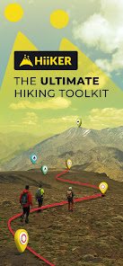
HiiKER: The Offline Hiking app
In-App-Käufe
3,9star
553 Rezensionen
50.000+
Downloads

Jedes Alter
info


Über diese App
HiiKER is an award-winning hiking app that is dedicated to building tools specifically for the hiking community.
Here are some of the key features of HiiKER (expanded below)
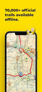
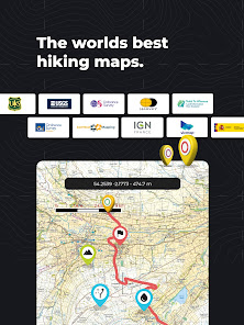
* Discover over 87,000 verified hiking trails
* Find campsites, hotels, huts, stores, motels, water sources etc
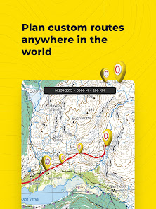
* Plan your own custom hiking route
* Record your Hikes
* Download hiking trails for FREE to navigate offline
* Create custom waypoints for Nav and Geocaching
* Import & Export GPX files for Free
* Choose from High-Resolution Map layers
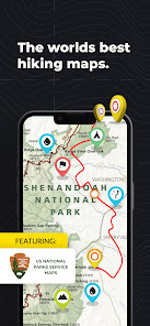
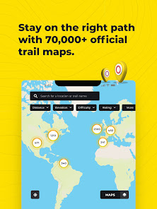
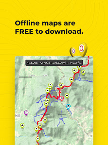
Download thousands of Hiking trail maps for FREE
With HiiKER, you can download over 87,000 of the world’s best hiking, walking and backpacking trails right to your smartphone for free. Looking for the perfect hiking trail? You’ll find the trail that’s right for you with our powerful trail search tool. And navigate it completely offline, for free.
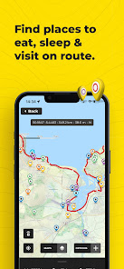
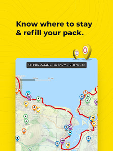
Points of Interest / Accommodation
You’ll find thousands of accommodation and amenity options for your adventures. Plan ahead with the perfect lunch spot, campsite, resupply town or maybe even a 5-star hotel on your hiking trip.
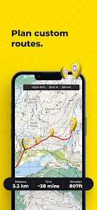
Plan custom hiking routes
The HiiKER Route Planner will enable you to blaze your own trail and plan a custom hiking route. Download your planned hiking route to your device for free and navigate offline. You can even share your hiking route with others or with your smart device, like Garmin, Apple watch or Google Fit.
Free Offline Hiking Maps
With HiiKER you can download all your favourite trails to your phone to use offline FOR FREE - even in airplane mode, so you can stay safe on the trail.
Waypoints & Geocaching
Place custom waypoints on any map and edit the details of the waypoint. Waypoints can be used to note campsites, gps coordinates, geocache locations, checkpoints and many other uses.
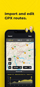
Import GPX files
Got a GPX file from a friend or another app like alltrails, onx, gaia gps, garmin, strava, komoot? Import it to HiiKER and make your own edits to the route before hitting the trail.
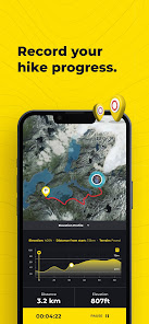
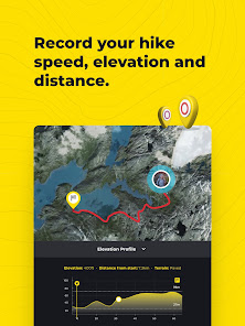
Record your Hikes
The HiiKER Tracker records your hiking activity and gives you in-depth detail about your adventures that you can share to Strava, Garmin and with your hiking community.
High-Resolution Map layers
We are building the most comprehensive selection of FREE map layers available. You'll find the layer that is best suited to your hike. These include
Open street maps (OSM)
Satellite
Nature
Mobile Atlas
Landscape
Pioneer
Transport
Free GPX Download
Export GPX files of one of the thousands of hiking trails on HiiKER for FREE. Sync them with your other gps devices, such as Garmin, suunto, coros etc.
HiiKER PRO+ pricing starts from $4.99 per month or $49.99 per year.
[PRO+] Measure the Distance
Use our handy measurement tool to know what distance, terrain and elevation lie ahead.
[PRO+] Stage by stage breakdown
Planning a longer hike and want to divide the trail into smaller segments? Our stage-by-stage breakdown helps you plan your days better with clever distance and elevation management.
[PRO+] Premium High-Resolution maps
Upgrading to HiiKER PRO+ gets you access to some of the world's best map developers in the world on the platform. These high-resolution maps include
US National Forests
USGS
National Park Service
Ordnance Survey UK
EastWest Mapping
IGN
OSi (Ireland) / Tailte
Swiss Topo
All of these maps can be used in conjunction with other HiiKER features.
Quality Data
We don’t just put any trail on HiiKER. We partner with trail organisations, National parks and other trusted sources around the world to bring you the most up-to-date and official trail data available.
These organisations are critical to the enjoyment and safety of hikers. As many are voluntary or NFP organisations, we give users the ability to donate to them for the valuable work they do.
Help and Support
Contact us at customer-support@hiiker.co
Legal
Terms of Service: https://hiiker.app/terms-of-service
Here are some of the key features of HiiKER (expanded below)
* Discover over 87,000 verified hiking trails
* Find campsites, hotels, huts, stores, motels, water sources etc
* Plan your own custom hiking route
* Record your Hikes
* Download hiking trails for FREE to navigate offline
* Create custom waypoints for Nav and Geocaching
* Import & Export GPX files for Free
* Choose from High-Resolution Map layers
Download thousands of Hiking trail maps for FREE
With HiiKER, you can download over 87,000 of the world’s best hiking, walking and backpacking trails right to your smartphone for free. Looking for the perfect hiking trail? You’ll find the trail that’s right for you with our powerful trail search tool. And navigate it completely offline, for free.
Points of Interest / Accommodation
You’ll find thousands of accommodation and amenity options for your adventures. Plan ahead with the perfect lunch spot, campsite, resupply town or maybe even a 5-star hotel on your hiking trip.
Plan custom hiking routes
The HiiKER Route Planner will enable you to blaze your own trail and plan a custom hiking route. Download your planned hiking route to your device for free and navigate offline. You can even share your hiking route with others or with your smart device, like Garmin, Apple watch or Google Fit.
Free Offline Hiking Maps
With HiiKER you can download all your favourite trails to your phone to use offline FOR FREE - even in airplane mode, so you can stay safe on the trail.
Waypoints & Geocaching
Place custom waypoints on any map and edit the details of the waypoint. Waypoints can be used to note campsites, gps coordinates, geocache locations, checkpoints and many other uses.
Import GPX files
Got a GPX file from a friend or another app like alltrails, onx, gaia gps, garmin, strava, komoot? Import it to HiiKER and make your own edits to the route before hitting the trail.
Record your Hikes
The HiiKER Tracker records your hiking activity and gives you in-depth detail about your adventures that you can share to Strava, Garmin and with your hiking community.
High-Resolution Map layers
We are building the most comprehensive selection of FREE map layers available. You'll find the layer that is best suited to your hike. These include
Open street maps (OSM)
Satellite
Nature
Mobile Atlas
Landscape
Pioneer
Transport
Free GPX Download
Export GPX files of one of the thousands of hiking trails on HiiKER for FREE. Sync them with your other gps devices, such as Garmin, suunto, coros etc.
HiiKER PRO+ pricing starts from $4.99 per month or $49.99 per year.
[PRO+] Measure the Distance
Use our handy measurement tool to know what distance, terrain and elevation lie ahead.
[PRO+] Stage by stage breakdown
Planning a longer hike and want to divide the trail into smaller segments? Our stage-by-stage breakdown helps you plan your days better with clever distance and elevation management.
[PRO+] Premium High-Resolution maps
Upgrading to HiiKER PRO+ gets you access to some of the world's best map developers in the world on the platform. These high-resolution maps include
US National Forests
USGS
National Park Service
Ordnance Survey UK
EastWest Mapping
IGN
OSi (Ireland) / Tailte
Swiss Topo
All of these maps can be used in conjunction with other HiiKER features.
Quality Data
We don’t just put any trail on HiiKER. We partner with trail organisations, National parks and other trusted sources around the world to bring you the most up-to-date and official trail data available.
These organisations are critical to the enjoyment and safety of hikers. As many are voluntary or NFP organisations, we give users the ability to donate to them for the valuable work they do.
Help and Support
Contact us at customer-support@hiiker.co
Legal
Terms of Service: https://hiiker.app/terms-of-service
Aktualisiert am
Was die Sicherheit angeht, solltest du nachvollziehen, wie Entwickler deine Daten erheben und weitergeben. Die Datenschutz- und Sicherheitspraktiken können je nach Verwendung, Region und Alter des Nutzers variieren. Diese Informationen wurden vom Entwickler zur Verfügung gestellt und können jederzeit von ihm geändert werden.

Keine Daten werden mit Drittunternehmen oder -organisationen geteilt

Diese App kann die folgenden Datentypen erheben
Standort, Fotos und Videos und 3 andere

Daten werden bei der Übertragung verschlüsselt

Du kannst das Löschen der Daten beantragen
Bewertungen und Rezensionen
4,0
534 Rezensionen

Timon Jenny
- Als unangemessen melden
- Rezensionsverlauf anzeigen
30. September 2020
Hervorragend. Sauberes und übersichtliches Interface, sehr übersichtliche Karten mit vielen Einstellungsmöglichkeiten! Edit: Bin mit der App die TMB gewandert. Die Navigation und Anzeige der Campingplätze war einwandfrei und hat mir so manches Ärgernis erspart!
5 Personen fanden diese Bewertung hilfreich
Waymarked Trails LTD
27. September 2019
Thanks, Timon. Really appreciate that! - Paul

Ein Google-Nutzer
- Als unangemessen melden
20. Januar 2020
Gerade installiert und kurz reingeschaut. Leider in NRW und Umgebung keine Eintragungen. Gibt es eine Möglichkeit, eigene Routen einzustellen? Ansonsten ist das Interface sehr einfach gehalten und wirklich tolle Routen bereits eingetragen. Für mich 4 Sterne Wert, wenn man jetzt noch eigene Routen anlegen und oder teilen kann, wäre die app perfekt.
1 Person fand diese Bewertung hilfreich

Hanna Cordes
- Als unangemessen melden
6. September 2020
Schade, dass nicht alle Routen enthalten sind wie auf der Website oder mache ich etwas falsch? Bedienung ist gut, nach einem Ort suchen zu können wäre hilfreich.
Waymarked Trails LTD
7. September 2020
Hi Hanna, We have version 3.0 of Hiiker coming tomorrow where you can search locations. There might be one or two trails that are only visible on version 3.0 due to the requirement of new features. Appreciate the feedback! Paul
Neuigkeiten
Bug fixing


