
Hawk Map Pro
4.6star
76 reviews
1K+
Downloads

Everyone
info
About this app
⭐⭐Pro Features⭐⭐
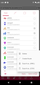
👉 List view for map markings.
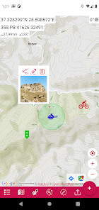
👉 Adding photos to map markings.
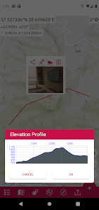
👉 Display an altitude graph for a drawn route.
👉 Location search by address.
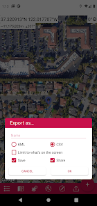
👉 Export the coordinates of the marked points in "CSV" format.
👉 More map options. (Topographic, cycling, etc.)
👉 Add custom map files in "mbtiles" format. (File content must be jpg or png, does not support vectors)
👉 Ability to add map url to be able to use maps of different map providers.
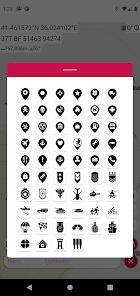
👉 More marker icons.
👉 Ad-free.
This app is a modern version of our "Mgrs & Utm Map" application.
GPS and coordinate systems helper especially for military personnel.
It is also a complete helper for airsoft, mountaineering, trekking and hiking, cross running, scouting, hunting, fishing, geocaching, off-road navigation and all other outdoor activities and sports.
With satellite navigation systems such as GPS, GALILEO and GLONASS (GNSS) supported by your device and your sensors, you can see your most accurate position on different map layers.
⭐⭐Features⭐⭐
👉 Coordinate Indicator, finder and converter
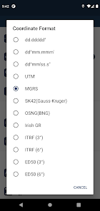
Format options:
- D°M'S" (WGS84)
- Latitude/Longitude (WGS84)
- UTM (WGS84/NAD83),
- MGRS / U.S. National Grid (USNG) (WGS84/NAD83)
- SK42(Gauss Kruger)
- British National Grid(BNG-OSNG)
- Irish Grid Reference
- ED50 (6°-3°)
- ITRF (6°-3°)
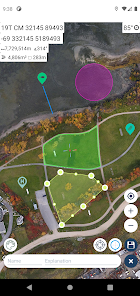
👉 You can make colored markings on the map.
Markers,Polygons,Polylines,Circles
👉 Area & Distance measurement
Distance unit options: m , ft , mi , yd , nmi
Area unit options: m² , ha , ft², yd², mi²
👉 Elevation information
👉 Compass
Angular unit options: Degrees ,NATO mil, Warsaw Mil, Grad
👉 Map style options: (Road,Terrain,Satellite,Night Mode,Hybrid)
👉 KML viewer. (Export and import KML layers).
👉 GPS track recorder.
👉 List view for map markings.
👉 Adding photos to map markings.
👉 Display an altitude graph for a drawn route.
👉 Location search by address.
👉 Export the coordinates of the marked points in "CSV" format.
👉 More map options. (Topographic, cycling, etc.)
👉 Add custom map files in "mbtiles" format. (File content must be jpg or png, does not support vectors)
👉 Ability to add map url to be able to use maps of different map providers.
👉 More marker icons.
👉 Ad-free.
This app is a modern version of our "Mgrs & Utm Map" application.
GPS and coordinate systems helper especially for military personnel.
It is also a complete helper for airsoft, mountaineering, trekking and hiking, cross running, scouting, hunting, fishing, geocaching, off-road navigation and all other outdoor activities and sports.
With satellite navigation systems such as GPS, GALILEO and GLONASS (GNSS) supported by your device and your sensors, you can see your most accurate position on different map layers.
⭐⭐Features⭐⭐
👉 Coordinate Indicator, finder and converter
Format options:
- D°M'S" (WGS84)
- Latitude/Longitude (WGS84)
- UTM (WGS84/NAD83),
- MGRS / U.S. National Grid (USNG) (WGS84/NAD83)
- SK42(Gauss Kruger)
- British National Grid(BNG-OSNG)
- Irish Grid Reference
- ED50 (6°-3°)
- ITRF (6°-3°)
👉 You can make colored markings on the map.
Markers,Polygons,Polylines,Circles
👉 Area & Distance measurement
Distance unit options: m , ft , mi , yd , nmi
Area unit options: m² , ha , ft², yd², mi²
👉 Elevation information
👉 Compass
Angular unit options: Degrees ,NATO mil, Warsaw Mil, Grad
👉 Map style options: (Road,Terrain,Satellite,Night Mode,Hybrid)
👉 KML viewer. (Export and import KML layers).
👉 GPS track recorder.
Updated on
Safety starts with understanding how developers collect and share your data. Data privacy and security practices may vary based on your use, region, and age. The developer provided this information and may update it over time.


Ratings and reviews
4.6
73 reviews

Jay Rodriguez
- Flag inappropriate
April 2, 2022
Is there an offline downloading of maps? That would be clutch as I'm in the Army. Sometimes in the field I lose service. I feature like Google maps where you can download an entire grid square and the bigger you make the square the bigger the download file is would be pretty cool. Other than that, the app seems to work pretty well.
3 people found this review helpful

Brian M. Smith
- Flag inappropriate
July 17, 2021
So far; works great. Well worth the money. My only wish is it could show NATO mils and degrees at the same time, without having to flip back and forth in the settings.
4 people found this review helpful

WMA Jarmekov
- Flag inappropriate
June 14, 2021
As a soldier, I find this app to be exceptional in every way. A few minor improvements and features could be very useful, but presently I have no complaints and strongly recommend it to my colleagues.
2 people found this review helpful
DakikTech
June 15, 2021
Thanks Jarmekov, I will continue to improve 🙋🏻♂️


