
My Track
Contains adsIn-app purchases
3.6star
12.9K reviews
1M+
Downloads

Everyone
info


About this app
My Track is a small and powerful application to keep track of your route while you go around. The quite complex functionality hides behind a very clear user interface which is easy to understand.
My Track can be very useful for all of your outdoor activities like hiking, bicycle and motorcycle touring, boating, skiing, climbing or sheer driving fun, it can also be used for business.
Have a look at all of these fancy features:
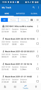
1. Record a route
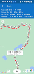
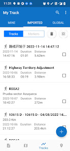
1.1 show current location on Google Map, along with time, duration and distance. even with latitude and longitude.
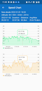
1.2 dynamic chart about speed and altitude.
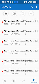
1.3 route recording, pausing, resuming, saving and listing.
1.4 photos joining with a route automatically, whatever app you use to take photos.
1.5 voice report at predefined frequency of time or distance when recording
1.6 export routes to GPX/KML/KMZ files, or import from your phone or Google Drive.
1.7 sync and restore from Google Drive.
1.8 do stats.
1.9 show multi routes on the map.
1.10 print a route with the map.
2. Share a route
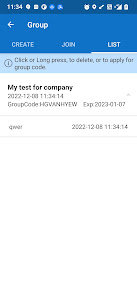
2.1 create a group and invite friends to join this group, you and your friends can share routes in this group.
2.2 share a route globally in this app.
2.3 share a route via web url to social medias, like WhatsApp, FaceBook, Gmail, etc.
2.4 select photos to share with a route.
3. Follow a route
3.1 follow your own route.
3.2 follow others’ shared route.
3.3 follow planned route.
3.4 fly your imagination: share a route in a group, friends in this group can follow this route.
4. Plan a route
4.1 plan a route(driving, bicycling and walking) among multi markers, the planed route can be followed on the map.
5. Markers
5.1 tap on the map to insert a marker, move the map to put the marker on proper position.
5.2 select markers to show on the map.
5.3 markers can be remembered to show next time when you open the app.
5.4 markers can be shared or exported within a route.
5.5 export markers to a KML file.
6. More
6.1 Live broadcast your locations to friends.
6.2 download offline map.
6.3 add map layer, and auto load this layer when the app starts.
6.4 click the map to measure distance, measure area, or to connect points to design a route line.
The app needs such permissions:
1. Storage permission for route saving.
2. Photo permission for joining photos with a route.
3. Location permission for route recording.
4. Internet permission for route sharing.
Attention:
1. Google Play and Google Maps should be installed first.
2. All features are free for all users.
3. After 15 days you may see ads, you can pay to remove.
4. After 60 days you may subscribe to advanced features, or watch a video to get one time's feature permission.
My Track can be very useful for all of your outdoor activities like hiking, bicycle and motorcycle touring, boating, skiing, climbing or sheer driving fun, it can also be used for business.
Have a look at all of these fancy features:
1. Record a route
1.1 show current location on Google Map, along with time, duration and distance. even with latitude and longitude.
1.2 dynamic chart about speed and altitude.
1.3 route recording, pausing, resuming, saving and listing.
1.4 photos joining with a route automatically, whatever app you use to take photos.
1.5 voice report at predefined frequency of time or distance when recording
1.6 export routes to GPX/KML/KMZ files, or import from your phone or Google Drive.
1.7 sync and restore from Google Drive.
1.8 do stats.
1.9 show multi routes on the map.
1.10 print a route with the map.
2. Share a route
2.1 create a group and invite friends to join this group, you and your friends can share routes in this group.
2.2 share a route globally in this app.
2.3 share a route via web url to social medias, like WhatsApp, FaceBook, Gmail, etc.
2.4 select photos to share with a route.
3. Follow a route
3.1 follow your own route.
3.2 follow others’ shared route.
3.3 follow planned route.
3.4 fly your imagination: share a route in a group, friends in this group can follow this route.
4. Plan a route
4.1 plan a route(driving, bicycling and walking) among multi markers, the planed route can be followed on the map.
5. Markers
5.1 tap on the map to insert a marker, move the map to put the marker on proper position.
5.2 select markers to show on the map.
5.3 markers can be remembered to show next time when you open the app.
5.4 markers can be shared or exported within a route.
5.5 export markers to a KML file.
6. More
6.1 Live broadcast your locations to friends.
6.2 download offline map.
6.3 add map layer, and auto load this layer when the app starts.
6.4 click the map to measure distance, measure area, or to connect points to design a route line.
The app needs such permissions:
1. Storage permission for route saving.
2. Photo permission for joining photos with a route.
3. Location permission for route recording.
4. Internet permission for route sharing.
Attention:
1. Google Play and Google Maps should be installed first.
2. All features are free for all users.
3. After 15 days you may see ads, you can pay to remove.
4. After 60 days you may subscribe to advanced features, or watch a video to get one time's feature permission.
Updated on
Safety starts with understanding how developers collect and share your data. Data privacy and security practices may vary based on your use, region and age The developer provided this information and may update it over time.


Ratings and reviews
3.6
12.6K reviews

Dick Rutgers
- Flag inappropriate
- Show review history
17 August 2024
Continuing to see improvements. What's a bit surprising to see that I now have to pay a monthly or yearly fee get all the features but I can understand that developer has to get paid somehow. (Can someone tell me how to export and save my information in case my phone breaks or I lose it? Seems that there used to be a way to export or update things to the cloud. Am I missing something somewhere?)
10 people found this review helpful
Daniel Qin
18 August 2024
Since you like it, why not take less than a cup of coffee price to subscribe monthly? we have designed the price low enough, every one can afford it. Nevertheless we provide extra service to answer your problems.

Kritter Robin
- Flag inappropriate
5 September 2024
I am a premium annual member. I like the simplicity of the application. However, sharing my trip show advertisements even though I am a premium member. If I am paying for premium service then why do my followers have to see ads? This should be removed as that is what you would expect from a premium subscription. So please remove the ads on sharing the location. It scare people to see these ads when all that they want to do is follow my trips.
2 people found this review helpful
Daniel Qin
6 September 2024
Hi, Kritter, thanks very much for your appreciation and subscription of this app, thanks very much for your valuable suggestion. The web application is totally different from the mobile application, I will collect more users' feedback and start to consider its' technical feasibility.

G Man
- Flag inappropriate
7 August 2020
I believe this is a replacement for my tracks v2.0.11 which is a better app. my tracks v2.0.11 has 3 screens that can be easily toggled from 3 buttons on top of the screen. 1st is the map with your track, 2nd is an easy to read screen with all the data: speed, time, elevation, distance ect., 3rd is a graph that shows your elevation changes which is nice to have on hikes or bike rides. This needs app is a gutted version.
11 people found this review helpful
Daniel Qin
7 August 2020
so, only 2 stars? This app is much powerful than the old one you mentioned.
What's new
V7.1.2:
An imported route can be moved to the My Route List.
The app will prompt when more than 100 routes are all selected.
An imported route can be moved to the My Route List.
The app will prompt when more than 100 routes are all selected.
App support
About the developer
Qin ZhiJian
qinzjy@gmail.com
RuiJin Two Road
黄浦区, 上海市
China
200120
undefined


