
Drone Scanner
2.7star
356 reviews
100K+
Downloads

Everyone
info


About this app
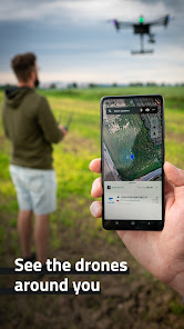
Transform your phone or tablet into a drone scanner and track all the nearby flights over Direct / Broadcast Remote ID standards. Browse real-time data about drones on a detailed map highlighting specific flying space zones. Download Drone Scanner for free and discover what drones fly above your head.
Favourite features:
- Discover more about drones flying nearby in real-time
- Examine detailed information broadcasted by drones via Bluetooth 4, Bluetooth 5, Wi-Fi Beacon, and Wi-Fi NAN
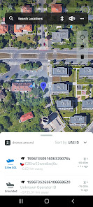
- Browse a detailed map with your location and all nearby aircraft
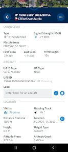
- Check available data about drones, including real-time height, direction, pilot identification, pilot position, operation description, and location history
- Various flying zones marked and highlighted on the map
- Easy export of collected data
- Continuously updated to reflect the latest EU & US regulations
All these features you find in Drone Scanner – a free app for tracking drones. The app is developed by Dronetag company manufacturing devices for drone remote identification.
How it works
Anyone can quickly identify what drones are flying in the sky nearby. Direct Remote ID is a feature that transmits live flight data via Bluetooth or Wi-Fi to the surrounding area. Drone manufacturers use various technologies to build an identification feature in new drones. Pilots of older drones are using add-on devices, enabling them to become digitally visible. With hardware on your smartphone, Drone Scanner can receive and read broadcasted data.
Favourite features:
- Discover more about drones flying nearby in real-time
- Examine detailed information broadcasted by drones via Bluetooth 4, Bluetooth 5, Wi-Fi Beacon, and Wi-Fi NAN
- Browse a detailed map with your location and all nearby aircraft
- Check available data about drones, including real-time height, direction, pilot identification, pilot position, operation description, and location history
- Various flying zones marked and highlighted on the map
- Easy export of collected data
- Continuously updated to reflect the latest EU & US regulations
All these features you find in Drone Scanner – a free app for tracking drones. The app is developed by Dronetag company manufacturing devices for drone remote identification.
How it works
Anyone can quickly identify what drones are flying in the sky nearby. Direct Remote ID is a feature that transmits live flight data via Bluetooth or Wi-Fi to the surrounding area. Drone manufacturers use various technologies to build an identification feature in new drones. Pilots of older drones are using add-on devices, enabling them to become digitally visible. With hardware on your smartphone, Drone Scanner can receive and read broadcasted data.
Updated on
Safety starts with understanding how developers collect and share your data. Data privacy and security practices may vary based on your use, region, and age. The developer provided this information and may update it over time.

No data shared with third parties
Learn more about how developers declare sharing

No data collected
Learn more about how developers declare collection
Ratings and reviews
2.7
329 reviews

Mike Burdette
- Flag inappropriate
April 6, 2024
The app is showing data in the metric system. Is there a way to change it to imperial measurements? The app connected to my Spectrum Sky Remote ID module without any problems, so I tried it out this evening. It actually worked quite well, but I saw a maximum altitude on my E-Flite Opterra of 411 m, which is apparently over 1300 ft. If I want to stay within the law, it sure would be easier to see my altitude in feet instead of meters. How do I change it?
1 person found this review helpful

David Quick
- Flag inappropriate
- Show review history
August 22, 2023
The app works great, however I'd like to have the ability to save the trace showing exactly what your drone's path was. So far the only way I can find to do so is to take a screenshot. Also, you loose that trace if you turn off the transponder. I'd love to have the ability to "save" before closing the app. Partly because if Karen accuses you of flying over her you have a way of showing you didn't.
52 people found this review helpful

Ron Flory
- Flag inappropriate
- Show review history
December 17, 2023
Works fine for me. I used a Spektrum A9500 RID module and Android phone. Once the RID module acquired GPS lock, it quickly showed up on the Drone Scanner app in the correct location and distance. Don't forget to turn Bluetooth ON. To those folks griping about having to use RID- don't blame DroneTag, after all, they are hobbyists just like us. We all hate the stupid way this whole RID thing is being forced upon us. I appreciate that they made this helpful app available. Thanks. ;)
22 people found this review helpful
What's new
We've added some new features and fixed a few bugs.
- Added feature to control Bluetooth scanning priority
- Added UAS Operator ID discrepancy checks
- Changed the permission requesting code
- Replaced the location autocomplete provider
- Fixed bugs web displaying altitude labels and unknown values
- Added feature to control Bluetooth scanning priority
- Added UAS Operator ID discrepancy checks
- Changed the permission requesting code
- Replaced the location autocomplete provider
- Fixed bugs web displaying altitude labels and unknown values


