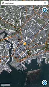
The Geoportail application brings together the 8 maps and data most popular with users of Geoportail, the reference geographic information portal on the national territory. View and locate yourself on: • The IGN map • The IGN topographic map • The classic IGN map • Aerial photographs • Cadastral plots • Aerial photographs 1950-1965 • Map of the General Staff 1820-1866 • Restricted areas UAS open category and model aircraft
2 geo-location modes are available: • simple (target activated in white): the position is tracked, the map remains fixed • tracked (target activated in white and filled in): the position is tracked, the map moves simultaneously
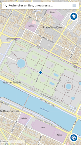
Using the display of coordinates via the central cross, obtain precise coordinates of any location (to be activated in the settings).
For more maps, data and tools, visit www.geoportail.gouv.fr
The current version of the application may no longer work on Android versions lower than version 7. Our teams are working to resolve the problem.
Updated on
Nov 15, 2023
Travel & Local
Data safety
arrow_forward
Safety starts with understanding how developers collect and share your data. Data privacy and security practices may vary based on your use, region, and age. The developer provided this information and may update it over time.