
Flood Maps & ZDs
In-app purchases
50+
Downloads

Everyone
info

About this app
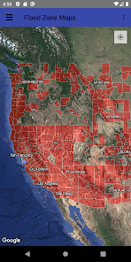
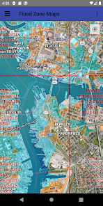
FLOOD ZONE quickly and easily gives you the FEMA designated flood zone of your current location or a point you choose on a map. Real estate agents, insurance agents, GIS professionals, surveyors, landowners and anyone with an interest in flood related products or services will find this app's subscription service easy, quick and very affordable.
Create the Standard Flood Hazard Determination Form (SFHDF) right on your mobile device. FLOOD ZONE automatically completes the SFHDF form including the Community and map panel information, and provides a map showing the property with the FEMA / NFIP overlay!
Realtors and Real estate agents: Add value to the service you provide. Top agents are knowledgeable of flood zones. Areas with a significant risk of flooding can be located miles away from bodies of water or rivers, and lender-required flood insurance can put a reasonably priced home out of the reach of some buyers. Use FLOOD ZONE to identify these properties and save yourself and buyers time and frustration. Listing agents and sellers can benefit, too. Purchasers need to know that increases in flood insurance premiums are affected by a property’s flood zone. The FLOOD ZONE app helps listing agents and sellers determine what they need to disclose when placing a home on the market.
Home Owners: FLOOD ZONE can help you monitor if your property’s flood zone has changed because of flood map redrawing. Are you near the boundary of two different zones? Use FLOOD ZONE to see how close you are to higher risk.
FLOOD ZONE shows FEMA approved flood hazard maps using National Flood Insurance Program data that is updated regularly. FLOOD ZONE is an informational tool and not a substitute for an elevation certificate performed by a qualified professional. Data is believed accurate but not guaranteed. This app is NOT an official NFIP or FEMA publication. Please refer to official FEMA and NFIP resources and appropriately qualified professionals for all related determinations.
You can customize the map to hide or show FIRM Panels, Flood Hazard Zones, LOMRs, LOMAs, River Mile Markers, Coastal Gages, Base Flood Elevations, Water Lines, Coastal Barrier Resources System Area, and Levees.
The app REQUIRES an auto-renew subscription to the online flood zone maps, offered as an in-app purchase. The app comes with a free trial of access to the flood zone maps before you have to buy anything.
Discounts may be provided for longer subscription periods. Payment will be charged to your Google Play Account at confirmation of purchase. Subscription automatically renews unless auto-renew is turned off at least 72-hours before the end of the current period. Account will be charged for renewal within 24-hours prior to the end of the current period, and identify the cost of the renewal.
Subscription auto-renewal may be turned off by going to the user's Account Settings after purchase. No cancellation of the current subscription is allowed during active subscription period. Any unused portion of a free trial period, if offered, will be forfeited when the user purchases a subscription to that publication.
https://www.ikonetics.com/app-site-terms-privacy.html
Updated on
Safety starts with understanding how developers collect and share your data. Data privacy and security practices may vary based on your use, region, and age. The developer provided this information and may update it over time.

No data shared with third parties
Learn more about how developers declare sharing

This app may collect these data types
App activity and App info and performance

Data is encrypted in transit

Data can’t be deleted
What’s new
Updated maps for the 2025 Hurricane Season!
App support
About the developer
IKONETICS LLC
ikonetics@gmail.com
1032 35th Ave N
Saint Petersburg, FL 33704
United States
+1 727-619-4561


