
Earth Viewer
3.9star
1.42K reviews
100K+
Downloads

Everyone
info


About this app
Earth Viewer
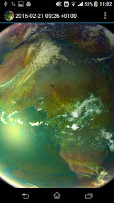
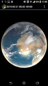
Animated planet Earth with live weather, satellite data, global forecast and historical data. Application visualizes also data-sets useful for Global warming monitoring.
How to use: Tap the 3 dots at the upper right hand corner (settings), and select a satellite view, it will then download for a few moments, (need internet access, be patient) then tap the play/pause and see the weather in motion
Imagery included:
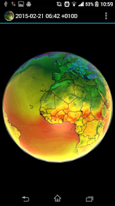
Climate Reanalyzer weather forecast
- World GFS Precipitation and Clouds (+7d)
- World GFS Air Temperature (+7d)
- World GFS Air Temperature Anomaly (+7d)
- World GFS Precipitable Water (+7d)
- World GFS Surface Wind Speed (+7d)
- World GFS Jetstream Wind Speed (+7d)
METEOSAT 0 degree satellite
- Airmass realtime imagery (-24h, generated every 1h)
- Airmass realtime imagery full resolution (-6h, generated every 1h)
METEOSAT IODC satellite
- IR 10.8 (-24h, generated every 3h)
SSEC
- Infrared low res global composite (-1w, generated every 3h)
- Water vapor low res global composite (-1w, generated every 3h)
Custom Imagery data
- Other and custom imagery data sources are supported by using json configuration
Application features:
- Interpolation between images
- Imagery selection from menu
- Live Sun light
- Bump mapping
- Data cache for offline use
- Double tap will stop/play animation
- Control animation speed by using +/- buttons
- Custom Imagery Data ("Edit Custom Data" button allows source imagery data configuration in json format)
Copyright and credit
CCI data has been obtained using Climate Reanalyzer (http://cci-reanalyzer.org), Climate Change Institute, University of Maine, USA.
NRL DATA has been obtained using United States Naval Research Laboratory, Marine Meteorology Division (http://www.nrlmry.navy.mil)
All METEOSAT images shown in the application are subject to EUMETSAT copyright.
For all NASA GOES images credit to NOAA-NASA GOES Project.
For all MTSAT images credit to Japan Meteorological Agency.
For all SSEC images provided courtesy of University of Wisconsin-Madison Space Science and Engineering Center.
Limitations
On some devices application will not launch and crash report is seen. This is caused in most cases by low graphical card capabilities or low amount of memory of the target device. Application use OpenGL ES 2.0 and extensive pixel shader with multitexturing.
Application is distributed as local image viewer which is accessing public available content from internet on behalf of user. Data are internally cached and only delta is downloaded. There is no guarantee for the availability of the downloaded data and the application also works without internet connectivity.
Program is distributed in the hope that it will be useful, but WITHOUT ANY WARRANTY.
Animated planet Earth with live weather, satellite data, global forecast and historical data. Application visualizes also data-sets useful for Global warming monitoring.
How to use: Tap the 3 dots at the upper right hand corner (settings), and select a satellite view, it will then download for a few moments, (need internet access, be patient) then tap the play/pause and see the weather in motion
Imagery included:
Climate Reanalyzer weather forecast
- World GFS Precipitation and Clouds (+7d)
- World GFS Air Temperature (+7d)
- World GFS Air Temperature Anomaly (+7d)
- World GFS Precipitable Water (+7d)
- World GFS Surface Wind Speed (+7d)
- World GFS Jetstream Wind Speed (+7d)
METEOSAT 0 degree satellite
- Airmass realtime imagery (-24h, generated every 1h)
- Airmass realtime imagery full resolution (-6h, generated every 1h)
METEOSAT IODC satellite
- IR 10.8 (-24h, generated every 3h)
SSEC
- Infrared low res global composite (-1w, generated every 3h)
- Water vapor low res global composite (-1w, generated every 3h)
Custom Imagery data
- Other and custom imagery data sources are supported by using json configuration
Application features:
- Interpolation between images
- Imagery selection from menu
- Live Sun light
- Bump mapping
- Data cache for offline use
- Double tap will stop/play animation
- Control animation speed by using +/- buttons
- Custom Imagery Data ("Edit Custom Data" button allows source imagery data configuration in json format)
Copyright and credit
CCI data has been obtained using Climate Reanalyzer (http://cci-reanalyzer.org), Climate Change Institute, University of Maine, USA.
NRL DATA has been obtained using United States Naval Research Laboratory, Marine Meteorology Division (http://www.nrlmry.navy.mil)
All METEOSAT images shown in the application are subject to EUMETSAT copyright.
For all NASA GOES images credit to NOAA-NASA GOES Project.
For all MTSAT images credit to Japan Meteorological Agency.
For all SSEC images provided courtesy of University of Wisconsin-Madison Space Science and Engineering Center.
Limitations
On some devices application will not launch and crash report is seen. This is caused in most cases by low graphical card capabilities or low amount of memory of the target device. Application use OpenGL ES 2.0 and extensive pixel shader with multitexturing.
Application is distributed as local image viewer which is accessing public available content from internet on behalf of user. Data are internally cached and only delta is downloaded. There is no guarantee for the availability of the downloaded data and the application also works without internet connectivity.
Program is distributed in the hope that it will be useful, but WITHOUT ANY WARRANTY.
Updated on
Safety starts with understanding how developers collect and share your data. Data privacy and security practices may vary based on your use, region, and age. The developer provided this information and may update it over time.

No data shared with third parties
Learn more about how developers declare sharing

No data collected
Learn more about how developers declare collection
Ratings and reviews
3.9
1.26K reviews

zagreb boris
- Flag inappropriate
- Show review history
March 21, 2023
Beautiful display of huge amount of different data!!! What is desperately missing is the color-key for their interpretation. And Start/Stop button on the main screen. Updated 7/2022 - some data are unavailable (ssec infrared, ssec water vapor...) Still missing Setup and key-colour bar. 21-3-2023 - after today's update, doesn't work at all. All data gone...
15 people found this review helpful
H21 lab
March 16, 2023
Start/Stop is performed by double tap. Color-key label has been added in the latest release. The data are downloaded from 3rd party servers, therefor the data could be sometime unavailable.

Rebecca Martin
- Flag inappropriate
October 11, 2020
Honestly it would be better if you could search locations on earth like zoom into earth and see buildings and stuff, but all you can do is zoom into the earth infinitly close. 4 star rating.
17 people found this review helpful

A Google user
- Flag inappropriate
October 27, 2019
I had originally just wanted live jetstream information but the other features are a real bonus. Check out the entire planet with a stroke of a finger! Well done!
13 people found this review helpful
What’s new
- Added animation speed +/- buttons
- Possible to add custom data sources using json file
- Added CCI EU and US rain rate prediction data
- Possible to add custom data sources using json file
- Added CCI EU and US rain rate prediction data
App support
About the developer
H21 lab s.r.o.
contact@h21lab.com
3756/10 Kopčianska
85101 Bratislava
Slovakia
+421 950 883 725


