
MyGeoMap
500+
Downloads

Everyone
info


About this app
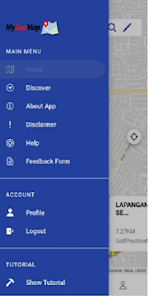
The MyGeoMap application is an application that displays geospatial location information to the public. The main functions of the application include the function of adding information by users (crowdsource), disaster reporting as well as navigation and navigation functions. Access to use the mobile application is also a new feature available in this application that makes it easier for users to reach and use this application at any time.
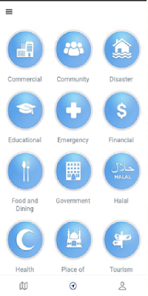
In the context of information sharing, this application serves as a catalyst for strategic collaboration between various Government and Private Agencies in sharing information which in turn makes this application an authentic and reliable information sharing platform. To date, a total of 17 Agencies have collaborated through information sharing categorized into 13 data categories namely Health Services, Institutions, Education, Community, Commercial, Disaster Management, Recreation and Tourism, Transport Services, Poultry Farm, Road Network, Land Use and Administrative Boundaries . Collaboration with other agencies is carried out from time to time based on the needs and appropriateness of the information that needs to be displayed in the Application.
In the context of information sharing, this application serves as a catalyst for strategic collaboration between various Government and Private Agencies in sharing information which in turn makes this application an authentic and reliable information sharing platform. To date, a total of 17 Agencies have collaborated through information sharing categorized into 13 data categories namely Health Services, Institutions, Education, Community, Commercial, Disaster Management, Recreation and Tourism, Transport Services, Poultry Farm, Road Network, Land Use and Administrative Boundaries . Collaboration with other agencies is carried out from time to time based on the needs and appropriateness of the information that needs to be displayed in the Application.
Updated on
Safety starts with understanding how developers collect and share your data. Data privacy and security practices may vary based on your use, region, and age. The developer provided this information and may update it over time.

No data shared with third parties
Learn more about how developers declare sharing

No data collected
Learn more about how developers declare collection

Data is encrypted in transit

Data can’t be deleted


