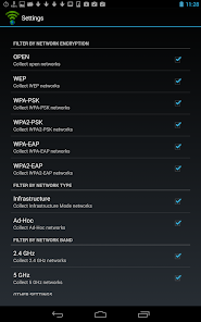
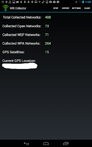
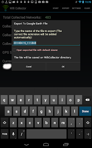
This app collects information about wireless networks and their location while you're walking on the streets or driving your car. For every wireless network, the following information is collected: network name (SSID), MAC address of the access point, company that manufactured the access point, signal level, channel frequency, channel number, security (WEP/WPA/WPA2), WPS support (Yes/No), Date/Time that the network was detected, and the location of the wireless network (Longitude and Latitude) taken from the GPS. After collecting the wireless networks information, you can export it into csv file, tab-delimited file, HTML file, or .kml file of Google Earth, which allows to view the location of all collected networks on a map of Google Earth.
This app requires a device with both Wifi component and GPS.
Warning !
The usage of both GPS and the wifi component by this app is quite intensive, so while using this app, your battery will be drained much faster than usual. Don't forget to click the Stop button when you want to finish collecting the wifi information.
Updated on
Feb 5, 2019
Tools
Data safety
arrow_forward
Safety starts with understanding how developers collect and share your data. Data privacy and security practices may vary based on your use, region, and age. The developer provided this information and may update it over time.