

WalkTracker: Hiking Trails
বিজ্ঞাপনযুক্ত

১০ হাজাৰ+
ডাউনল’ড

সকলো
info


এই এপ্টোৰ বিষয়ে
Go outdoors and discover beautiful nature around the planet by using this free, no-nonsense, easy-to-use: WalkTracker - which will turn your Android device instantly into a high quality GPS tracking device. You can also import a pre recorded GPX track from any source/website to navigate you to explore new amazing hiking tracks. The adventure is out there!
Experience this instantly by installing the app now! There is no need to create an account. No logins/passwords required to remember and no hidden extra costs, even the offline maps are for free.
The application has been developed by, and specially designed and tuned for walkers/hikers. This means a low energy consumption so it can track for a long time/long distance. Prepare yourself at home by downloading the offline maps of the area you plan to visit (see Settings), so no expensive mobile operator costs when you are on route and no worries about places with poor signal.
WalkTracker is for experienced and novice hikers for short or long distances.
- Tracking / Recording hike
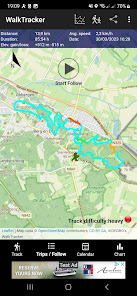
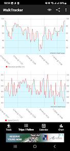
WalkTracker will record your hiked route, calculate distance, speed and elevation gained. A smart algorithm will calculate for every completed track a 'difficulty indicator' (easy/moderate/heavy).
You can share the GPS data with friends and/or your social network by pressing the share-button. Send an image of the track, elevation profile and/or GPX file to email, Facebook, Instagram, Signal, Telegram, WhatsApp, WalkTracker Wiki and/or any other compatible application. The WalkTracker Wiki is a website containing hiking trails, shared by the community of WalkTracker users.
The app will submit every completed 5 km a notification i.e. to your connected smartwatch. Of course you can change from kilometers to miles or change this distance interval or switch it off.
- Following / Navigating pre recorded GPX track
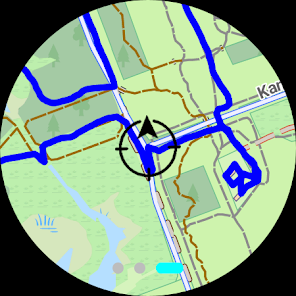
Besides of recording your track as GPX, you can follow those tracks too. You will receive turn-by-turn navigation instructions at your Android device and/or at your connected watch. Besides of that you see a map with the route, your current location and a compass. To import a track, send a GPX file as attachment by email. Open the attachment or GPX file in the file explorer using 'WalkTracker'.
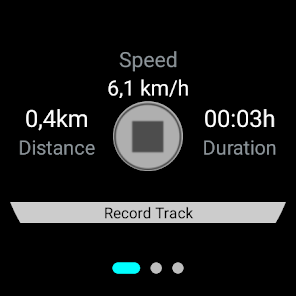
In the latest version your smartwatch / Wear OS device is an extension for this (accompanying) app, kind of a remote control, which will not function standalone. You can start/stop tracking from your watch. While you are moving (needs location updates), you see the average speed, duration an distance of the track. Using the Following function, you will see a compass with direction information. It is important that your mobile device (phone) is receiving location updates. After an interval, to reduce battery consumption, you will see your progress on your watch.
How to use your smartwatch (Wear OS) to control the accompanying mobile app?
1) Pair WearOS- and Android (mobile)- device
2) Install WalkTracker app both at your Mobile (Android) and Smartwatch (WearOS)
3) Start app at Mobile and give Location permission while using app
4) Start app at Smartwatch
5) Press 'arrow to the right'-button to start recording your hike
6) Start walking to see speed, distance and duration at your watch
Need at least two location updates to see relevant data.
Please report any bugs before giving negative feedback so we can fix them as soon as possible (In Google Play - Developer - Send email).
More information: http://blog.videgro.net/2014/08/walktracker/
Experience this instantly by installing the app now! There is no need to create an account. No logins/passwords required to remember and no hidden extra costs, even the offline maps are for free.
The application has been developed by, and specially designed and tuned for walkers/hikers. This means a low energy consumption so it can track for a long time/long distance. Prepare yourself at home by downloading the offline maps of the area you plan to visit (see Settings), so no expensive mobile operator costs when you are on route and no worries about places with poor signal.
WalkTracker is for experienced and novice hikers for short or long distances.
- Tracking / Recording hike
WalkTracker will record your hiked route, calculate distance, speed and elevation gained. A smart algorithm will calculate for every completed track a 'difficulty indicator' (easy/moderate/heavy).
You can share the GPS data with friends and/or your social network by pressing the share-button. Send an image of the track, elevation profile and/or GPX file to email, Facebook, Instagram, Signal, Telegram, WhatsApp, WalkTracker Wiki and/or any other compatible application. The WalkTracker Wiki is a website containing hiking trails, shared by the community of WalkTracker users.
The app will submit every completed 5 km a notification i.e. to your connected smartwatch. Of course you can change from kilometers to miles or change this distance interval or switch it off.
- Following / Navigating pre recorded GPX track
Besides of recording your track as GPX, you can follow those tracks too. You will receive turn-by-turn navigation instructions at your Android device and/or at your connected watch. Besides of that you see a map with the route, your current location and a compass. To import a track, send a GPX file as attachment by email. Open the attachment or GPX file in the file explorer using 'WalkTracker'.
In the latest version your smartwatch / Wear OS device is an extension for this (accompanying) app, kind of a remote control, which will not function standalone. You can start/stop tracking from your watch. While you are moving (needs location updates), you see the average speed, duration an distance of the track. Using the Following function, you will see a compass with direction information. It is important that your mobile device (phone) is receiving location updates. After an interval, to reduce battery consumption, you will see your progress on your watch.
How to use your smartwatch (Wear OS) to control the accompanying mobile app?
1) Pair WearOS- and Android (mobile)- device
2) Install WalkTracker app both at your Mobile (Android) and Smartwatch (WearOS)
3) Start app at Mobile and give Location permission while using app
4) Start app at Smartwatch
5) Press 'arrow to the right'-button to start recording your hike
6) Start walking to see speed, distance and duration at your watch
Need at least two location updates to see relevant data.
Please report any bugs before giving negative feedback so we can fix them as soon as possible (In Google Play - Developer - Send email).
More information: http://blog.videgro.net/2014/08/walktracker/
আপডে’ট কৰা তাৰিখ
বিকাশকৰ্তাসকলে আপোনাৰ ডেটা কেনেকৈ সংগ্ৰহ আৰু শ্বেয়াৰ কৰে সেয়া বুজি পোৱাৰ জৰিয়তে সুৰক্ষা আৰম্ভ হয়। ডেটাৰ গোপনীয়তা আৰু সুৰক্ষা প্ৰণালী আপোনাৰ ব্যৱহাৰ, অঞ্চল আৰু বয়সৰ ওপৰত ভিত্তি কৰি ভিন্ন হ’ব পাৰে। বিকাশকৰ্তাগৰাকীয়ে এই তথ্যখিনি প্ৰদান কৰিছে আৰু সময়ৰ লগে লগে এয়া আপডে’ট কৰিব পাৰে।


নতুন কি আছে
- Wear OS support
- Garmin BaseCamp compatible
- Offline maps
- Follow GPX/GPS track
- Import GPX files
- Colorize route depending on speed
- Track difficulty indicator
- Charts of Trip (average speed/elevation gain) and Trips-stats (average speed/distance/elevation gain)
- Show completed distance during tracking when entering Track-view
- Submit every completed 5km a notification