
Map GPX Grid Creator
4.7star
13 reviews
100+
Downloads

Everyone
info

About this app
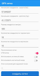
Application for creating grids in GPX format for geographic maps of navigators:
- Setting the starting point of the grid
- With binding to UTM nodes (WGS 84).
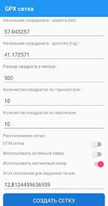
- Orientation of the grid in true north
- Orientation of the grid in magnetic north, with the calculation of the angle of declination for a given starting point.
- Variable grid pitch (in meters)
- Setting the number of grid squares horizontally and vertically
- Naming and numbering of grid nodal points in the format A1, A2, B1, B2 ... etc.
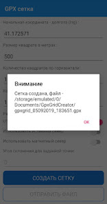
- Export to GPX file.
- Sending the created GPX file via installed messengers, email clients, etc.
- Setting the starting point of the grid
- With binding to UTM nodes (WGS 84).
- Orientation of the grid in true north
- Orientation of the grid in magnetic north, with the calculation of the angle of declination for a given starting point.
- Variable grid pitch (in meters)
- Setting the number of grid squares horizontally and vertically
- Naming and numbering of grid nodal points in the format A1, A2, B1, B2 ... etc.
- Export to GPX file.
- Sending the created GPX file via installed messengers, email clients, etc.
Updated on
Safety starts with understanding how developers collect and share your data. Data privacy and security practices may vary based on your use, region and age The developer provided this information and may update it over time.

No data shared with third parties
Learn more about how developers declare sharing

No data collected
Learn more about how developers declare collection
Ratings and reviews
4.7
13 reviews
What's new
- Добавлена возможность установки произвольного размера квадрата сетки в метрах.


