CityBus Kharkiv
Contains adsIn-app purchases
4.6star
6.85K reviews
100K+
Downloads

Mature 17+
info


About this app
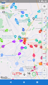
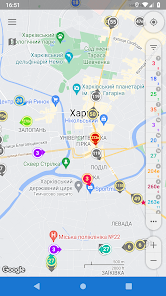
Smart app for tracking public transport of Kharkiv.
* ATTENTION! Location data is available for communal vehicles (trolleys, trams and buses). In addition to those, only certain bus routes (mainly suburban) are currently available for monitoring, which are served by ATP 16329. Due to the nature of the carrier’s work, individual vehicles may be located on other routes than indicated in the app. Routes with potentially available vehicles online are marked differently.
* Main app function - transport tracking - depends on the functioning of an external source of GPS data. Cooperation of the source and app is not guaranteed. Also, given the significant intervals of data updates sometimes, there may be some differences between the real transport position and the one that shown in the application.
- Only actual information. CityBus filters data not to show you things, which aren't there.
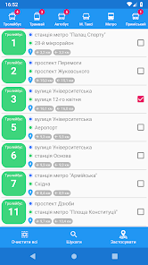
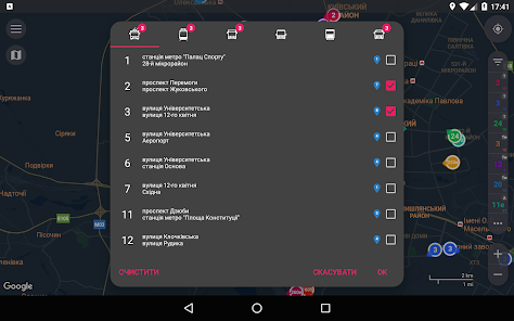
- Favourites. CityBus gives you possibility to save your favorite routes lists and apply them in just a couple of taps.
- Smart view. On map zoom in you will see all vehicles, equipped with GPS-trackers, not only of selected routes.
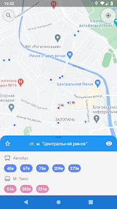
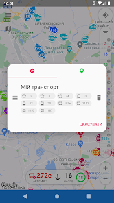
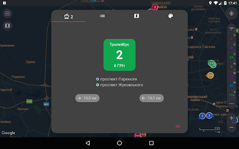
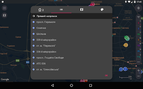
- Routes search. You only need to choose two points on a map, search results could be filtered and applied to display suitable vehicles.
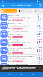
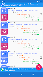
- Real-time transition. Received info about coordinates, speed and heading is enough to predict with high probability real-time vehicle location. Displaying movement on a map is animated, almost no jumps.
- Traffic optimization. All useful info is already inside this app.
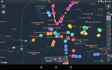
- Speed and heading visualization. Only one glance at map allows you to determine heading and speed of vehicles you need. Depending on speed changes size of colored area of ring around marker, and its center points in a direction the bus is heading.
- Color routes identification. Distinguishing routes is quite easy, 'cause every selected route is determined not only by its number, but although by color of its marker.
Bus routes are based on information provided by the Kharkiv Transport website http://gortransport.kharkov.ua/
The application uses open data provided by the Kharkiv City Council (http://data.city.kharkov.ua/) on the basis of the Law of Ukraine "About access to public information"
* ATTENTION! Location data is available for communal vehicles (trolleys, trams and buses). In addition to those, only certain bus routes (mainly suburban) are currently available for monitoring, which are served by ATP 16329. Due to the nature of the carrier’s work, individual vehicles may be located on other routes than indicated in the app. Routes with potentially available vehicles online are marked differently.
* Main app function - transport tracking - depends on the functioning of an external source of GPS data. Cooperation of the source and app is not guaranteed. Also, given the significant intervals of data updates sometimes, there may be some differences between the real transport position and the one that shown in the application.
- Only actual information. CityBus filters data not to show you things, which aren't there.
- Favourites. CityBus gives you possibility to save your favorite routes lists and apply them in just a couple of taps.
- Smart view. On map zoom in you will see all vehicles, equipped with GPS-trackers, not only of selected routes.
- Routes search. You only need to choose two points on a map, search results could be filtered and applied to display suitable vehicles.
- Real-time transition. Received info about coordinates, speed and heading is enough to predict with high probability real-time vehicle location. Displaying movement on a map is animated, almost no jumps.
- Traffic optimization. All useful info is already inside this app.
- Speed and heading visualization. Only one glance at map allows you to determine heading and speed of vehicles you need. Depending on speed changes size of colored area of ring around marker, and its center points in a direction the bus is heading.
- Color routes identification. Distinguishing routes is quite easy, 'cause every selected route is determined not only by its number, but although by color of its marker.
Bus routes are based on information provided by the Kharkiv Transport website http://gortransport.kharkov.ua/
The application uses open data provided by the Kharkiv City Council (http://data.city.kharkov.ua/) on the basis of the Law of Ukraine "About access to public information"
Updated on
Safety starts with understanding how developers collect and share your data. Data privacy and security practices may vary based on your use, region, and age. The developer provided this information and may update it over time.


Ratings and reviews
4.6
6.79K reviews

Таня Орлова
- Flag inappropriate
January 20, 2022
Класний додаток. Користуюсь вз задоволенням. Наприклад, щоб довго не стояти на зупинці, дивлюсь наперед карту і виходжу. Тільки чомусь сьогодні перестало працювати. Можливо це тимчасово.
d.u.a.l
January 21, 2022
Дякую. Вчора мав місце досить тривалий збій на міському сервісі, звідки додаток отримує дані місцезнаходження транспорту, який тривав понад 3 години, починаючи з 10-ї ранку. На жаль, робота цього сервісу - поза моєю компетенцією 🤷♂️ Зараз все працює, за винятком відслідковування більшості автобусів, які зникли ще з вихідних і досі не з'явились...

Ucyca Production
- Flag inappropriate
December 19, 2021
Приложение лучшее среди остальных, но наличие определенной версии Гугл сервисов усложняет использование данного по :(
1 person found this review helpful
d.u.a.l
December 20, 2021
Не зрозумів, у чому полягає претензія? Ваш пристрій не сертифіковано Google Play і тому сервіси на ньому не працюють як слід? Така проблема часом буває із китайськими телефонами, в т.ч. meizu, на жаль - але такі ризики потрібно було враховувати при покупці 🤷♂️

Сергей Шмандий
- Flag inappropriate
April 28, 2021
Очень полезное приложение для отслеживания местного транспорта. Пользуюсь регулярно. Чтобы добавил для удобства: 1. Время работы выбранного транспорта (с и до); 2. Сделать остановки более крупными, чтобы их было удобнее выбирать (при нажатии на остановку сложно попасть на мелкий кружок на карте).
d.u.a.l
May 5, 2021
Дякую. 1. На жаль, такої інформації немає, та й вона дуже часто втрачає актуальність 🤷♂️ 2. Складно попасти не тому, що зупинки маленького розміру, а тому, що поряд є інші маркери (тих же зупинок або транспорту). Якщо наблизити карту, то натискати буде простіше. Робити зупинки великими - не вихід, вони лише будуть сильніше засмічувати карту
What's new
- Redesign of controls in the map area (list of selected routes, information about transport, buttons, etc.)
- Block of information about the selected transport: added the final destination and the vehicle model; clicking on the colored block with the route number shows/hides the route on the map
- Search history: previously searched points will appear in the tooltips of the address input fields
- Icons for tooltips in the address input fields depending on the type (history, stops, addresses)


