G Peak Pro Bike Computer
100+
Downloads

Everyone
info
About this app
Turn your phone into a complete road computer for a more enjoyable time with your bike!
Take your adventure to the next level with G Peak Lite, the best app for MTB ciler and City bikes!
G Peak Lite turns your smartphone into a bike computer with 90+ exciting features. Whether you have your favorite route or not, the G Peak Lite is your perfect roadside assistant.
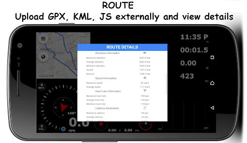
It is also the only trip computer application that can open your routes in GPX, KML, KMZ, CSV, TCX and JS formats !!
Strong basic features
* Sensor support
-- Heart rate sensor
-- Speed sensor
-- Cadence sensor
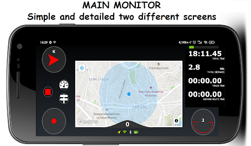
* Two different home screens
-- Simple screen
-- Detailed screen
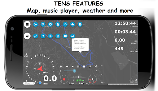
* Speedometer
-- Instant speed
-- Maximum speed
-- Average speed
* G force measurement
-- instantaneous force of g
-- Maximum acceleration force g
-- Maximum deceleration force g
* Compass (in Direction and Degrees)
* Acceleration indicator
-- Instant acceleration
-- Maximum acceleration
* Angle indicator
-- Instant bike's inclination to the road
* Slope (every 25 meters)
-- instantaneous slope
-- Maximum descent slope
-- Average descent slope
-- Maximum output slope
-- Average output slope
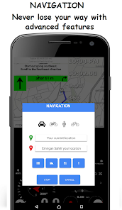
* Navigation (Pro version)
-- 4 different route options
-- Automatic route creation when off-route
-- Voice guidance
* Music player
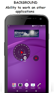
* Ability to work on other apps and on the lock screen (Pro version)
* Weather information
-- Temperature
-- Wind speed
-- Wind direction
-- Humidity
-- sunrise
-- Sunset
-- Atmospheric pressure
-- Weather zone name
-- Weather detail
* Distance information
-- daily distance
-- Total distance
-- Route distance
-- Route descent distance
-- Route climb distance
-- Route straight distance
* Height information
-- instantaneous altitude
-- Height difference
-- Height earned
-- Height lost
-- Maximum height
-- Minimum height
* Duration information
-- Time and date
-- Daily working time
-- Total working time
-- Total route time
-- Moving route time
-- Music playing time
-- Music length time
* Route location bar
-- Switching between locations in Saved Route
-- The current location of the selected location;
-- Show Speed, Altitude, Heart Rate, Cadence and Distance information
* 8 Different 3D Mapbox Map layers (Pro version)
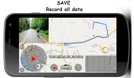
* Track recording and viewing
-- Track recording (in GPX, JS format)
-- Viewing track record (in GPX, KML, CSV, KMZ, TCX and JS format)
-- Share track record
-- Creating waypoints
-- Adding pictures to waypoints
* Creating waypoints
-- Creating waypoints while recording or in the recorded route
-- Adding pictures to waypoints
* Calories measurement
-- Total calories
-- Average calorie (Hour / Calorie)
* Energy measurement (every 25 meters)
-- Instant energy
-- Maximum energy
-- Average energy
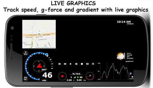
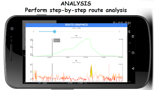
* Graphics
-- Instant speed graph
-- Instant heart rate graph
-- Instant cadence graph
-- Route elevation graph
-- Route speed chart
-- Route heart rate graph
-- Route cadence chart
-- Weather graph (5 days and hourly)
* Personal information screen
-- 7 different information screens
-- Changeable text color
-- Changeable font
* Camera
-- Front and rear camera switching
-- Taking pictures
-- Add effects to camera
-- Screen capture
* Connection symbols (BT, INT., GPS)
* Headlight
* Horn
* Battery status icon
* Screen touch blocking
* Language support
-- Turkish
-- The English
-- German
-- French
-- Italian
Take your adventure to the next level with G Peak Lite, the best app for MTB ciler and City bikes!
G Peak Lite turns your smartphone into a bike computer with 90+ exciting features. Whether you have your favorite route or not, the G Peak Lite is your perfect roadside assistant.
It is also the only trip computer application that can open your routes in GPX, KML, KMZ, CSV, TCX and JS formats !!
Strong basic features
* Sensor support
-- Heart rate sensor
-- Speed sensor
-- Cadence sensor
* Two different home screens
-- Simple screen
-- Detailed screen
* Speedometer
-- Instant speed
-- Maximum speed
-- Average speed
* G force measurement
-- instantaneous force of g
-- Maximum acceleration force g
-- Maximum deceleration force g
* Compass (in Direction and Degrees)
* Acceleration indicator
-- Instant acceleration
-- Maximum acceleration
* Angle indicator
-- Instant bike's inclination to the road
* Slope (every 25 meters)
-- instantaneous slope
-- Maximum descent slope
-- Average descent slope
-- Maximum output slope
-- Average output slope
* Navigation (Pro version)
-- 4 different route options
-- Automatic route creation when off-route
-- Voice guidance
* Music player
* Ability to work on other apps and on the lock screen (Pro version)
* Weather information
-- Temperature
-- Wind speed
-- Wind direction
-- Humidity
-- sunrise
-- Sunset
-- Atmospheric pressure
-- Weather zone name
-- Weather detail
* Distance information
-- daily distance
-- Total distance
-- Route distance
-- Route descent distance
-- Route climb distance
-- Route straight distance
* Height information
-- instantaneous altitude
-- Height difference
-- Height earned
-- Height lost
-- Maximum height
-- Minimum height
* Duration information
-- Time and date
-- Daily working time
-- Total working time
-- Total route time
-- Moving route time
-- Music playing time
-- Music length time
* Route location bar
-- Switching between locations in Saved Route
-- The current location of the selected location;
-- Show Speed, Altitude, Heart Rate, Cadence and Distance information
* 8 Different 3D Mapbox Map layers (Pro version)
* Track recording and viewing
-- Track recording (in GPX, JS format)
-- Viewing track record (in GPX, KML, CSV, KMZ, TCX and JS format)
-- Share track record
-- Creating waypoints
-- Adding pictures to waypoints
* Creating waypoints
-- Creating waypoints while recording or in the recorded route
-- Adding pictures to waypoints
* Calories measurement
-- Total calories
-- Average calorie (Hour / Calorie)
* Energy measurement (every 25 meters)
-- Instant energy
-- Maximum energy
-- Average energy
* Graphics
-- Instant speed graph
-- Instant heart rate graph
-- Instant cadence graph
-- Route elevation graph
-- Route speed chart
-- Route heart rate graph
-- Route cadence chart
-- Weather graph (5 days and hourly)
* Personal information screen
-- 7 different information screens
-- Changeable text color
-- Changeable font
* Camera
-- Front and rear camera switching
-- Taking pictures
-- Add effects to camera
-- Screen capture
* Connection symbols (BT, INT., GPS)
* Headlight
* Horn
* Battery status icon
* Screen touch blocking
* Language support
-- Turkish
-- The English
-- German
-- French
-- Italian
Updated on
Safety starts with understanding how developers collect and share your data. Data privacy and security practices may vary based on your use, region, and age. The developer provided this information and may update it over time.

No data shared with third parties
Learn more about how developers declare sharing

No data collected
Learn more about how developers declare collection
What's new
* Added power sensor support.
* Can now view .gps route files.
* "Energy" graph has been added to the route graphs screen.
* Added "General Settings >> Navigation Settings >> Guidance sounds".
* Instant power graph has been added to the main screen.
* File type filtering feature has been added to the route menu.
* Energy data is now saved in the .gpx file type when recording a route.
* Music player; now only plays if in the foreground, pauses if it is in the background.
App support
phone
Phone number
+905455646163


