
AllTrails tips and tricks
Planning your next hike doesn’t have to be a solo mission. Team up with AllTrails, an app that hikers all over the world use to prepare for outdoor adventures. Explore these app insights to make sure that you’ve got all the info that you need for your journey.
AllTrails

AllTrails: Hike, Cycle & Run
AllTrails, LLC
Contains adsIn-app purchases

4.7star
368K reviews
10M+
Downloads

Everyone
info
- 1The ultimate path finder: explore hiking and biking routes with a slick search tool and helpful details
- 2Browse the map or search by city, park, or track name — then filter by length, difficulty, and more
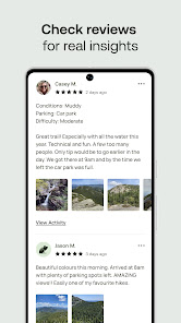
- 3Read reviews with photos so you know what to expect before you go


Find your hike
To find your new favourite hike, open up the app, tap 'Explore' in the bottom-left corner and then tap the map icon. You’ll immediately see your current location and any hikes located near you. If you can't see any markers in your vicinity, just pinch and zoom out to view more of the landscape.
Dig into the details
To whittle down your options, use filters such as distance from your current location, trail traffic, difficulty and activities such as running or mountain biking. Tap on a listing to get quick access to a trail’s information, including user ratings and estimated hike time. Tap the listing bubble at the bottom of the screen to expand for more details such as elevation gain, route type and accessibility. Most importantly, you’ll see reviews from other hikers including tips on trailheads, scenic views and recent trail conditions.
Tip
With an AllTrails+ account, you can tap 'Preview trail' to experience a 3D walkthrough of any trail, allowing you to better visualise the route and its elevation changes.
Explore with multiple maps
Tap the map on a trail’s details page for an expanded, interactive view. Want to know the ups and downs that await you? Drag your finger along the elevation graph and you’ll see the blue dot move along the trail, showing you exactly where the elevation changes occur.
View digital markers for nearby trails and waypoints such as attractions and trailheads along your path. With an AllTrails+ account, you can also choose from alternate map types like 3D, roadways, satellite view and topographic.
View digital markers for nearby trails and waypoints such as attractions and trailheads along your path. With an AllTrails+ account, you can also choose from alternate map types like 3D, roadways, satellite view and topographic.
Tip
Even without mobile service, your phone’s GPS can track you as you wander the trail. Download trail maps (AllTrails+ account required) to get full access to the digital terrain when service isn’t available.

Navigate with confidence
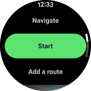
When you’re on a trail within mobile service range, you can tap 'Navigate' from the trail details page to get help finding your way. If you’re doing something other than hiking, tap the 'Activity' icon and choose from options like horse riding, off-road driving and even bird watching. When you’re ready, press 'Start.'
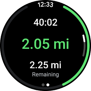
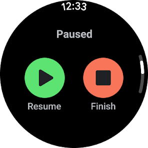
As you wander the trail, the app will track distance, time, speed, average pace and more. Tap the layers icon to switch between map types and select the three dots to add waypoints and photos to your trip. When your hike’s complete, hold the 'Pause' button and then tap 'Finish', saving the route with all its related data to your account. From the 'Saved' tab in the app, you can share completed activities with friends and compare notes with other hikers.
As you wander the trail, the app will track distance, time, speed, average pace and more. Tap the layers icon to switch between map types and select the three dots to add waypoints and photos to your trip. When your hike’s complete, hold the 'Pause' button and then tap 'Finish', saving the route with all its related data to your account. From the 'Saved' tab in the app, you can share completed activities with friends and compare notes with other hikers.
Tip
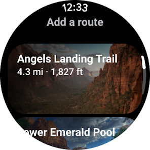
Have a smartwatch? Use the AllTrails Wear OS app to find nearby trails, record your activity, see how much farther you have to go and even get a notification when you’ve missed a turn.

AllTrails: Hike, Cycle & Run
AllTrails, LLC
Contains adsIn-app purchases
4.7star
368K reviews
10M+
Downloads
Everyone
info