
COtrip Planner
2.9star
436 reviews
Government
info
100K+
Downloads

Everyone
info


About this app
The COtrip app is the Colorado Department of Transportation's (CDOT) official real-time traffic and traveler information app. The COtrip app provides statewide travel information for Colorado’s interstates, U.S. routes and state highways. It does not include information for county roads or city streets.
Features:
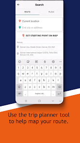
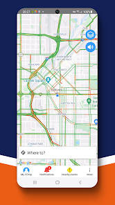
- Zoomable and mobile-friendly map display
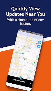
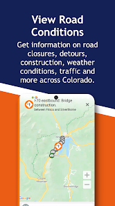
- Traffic speeds and road conditions
- Real-time updates on road maintenance, construction, restrictions and road closures
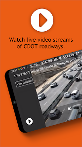
- Camera images and live streaming video
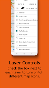
- Trucker mode with resources specific to commercial motor vehicle operators
- Winter weather conditions (seasonal)
- Plow tracker
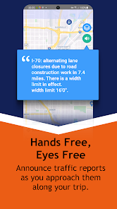
- Hands-free, eyes-free feature to announce upcoming road conditions that will impact your route
Please Note: Continued use of GPS running in the background can decrease device battery life.
Drop the Distraction
The primary responsibility of every driver is the safe operation of their vehicle. While traveling, mobile communication devices should be used only when the motor vehicle is at a complete stop off the traveled portion of the roadway. Do not text and drive (it's against the law) or use this app while driving. For more information about distracted driving in Colorado and safety tips, visit https://distracted.codot.gov.
Feedback
We welcome your feedback on this app. Please send your suggestions, questions or concerns in an email to cdot_cotrip@state.co.us. For tutorials and more information, visit COtrip.org.
CDOT Privacy Policy: https://codot.gov/topcontent/privacypolicy
Features:
- Zoomable and mobile-friendly map display
- Traffic speeds and road conditions
- Real-time updates on road maintenance, construction, restrictions and road closures
- Camera images and live streaming video
- Trucker mode with resources specific to commercial motor vehicle operators
- Winter weather conditions (seasonal)
- Plow tracker
- Hands-free, eyes-free feature to announce upcoming road conditions that will impact your route
Please Note: Continued use of GPS running in the background can decrease device battery life.
Drop the Distraction
The primary responsibility of every driver is the safe operation of their vehicle. While traveling, mobile communication devices should be used only when the motor vehicle is at a complete stop off the traveled portion of the roadway. Do not text and drive (it's against the law) or use this app while driving. For more information about distracted driving in Colorado and safety tips, visit https://distracted.codot.gov.
Feedback
We welcome your feedback on this app. Please send your suggestions, questions or concerns in an email to cdot_cotrip@state.co.us. For tutorials and more information, visit COtrip.org.
CDOT Privacy Policy: https://codot.gov/topcontent/privacypolicy
Updated on
Safety starts with understanding how developers collect and share your data. Data privacy and security practices may vary based on your use, region, and age. The developer provided this information and may update it over time.

No data shared with third parties
Learn more about how developers declare sharing

No data collected
Learn more about how developers declare collection

Data is encrypted in transit

You can request that data be deleted
Ratings and reviews
2.9
423 reviews

Ryan Patterson
- Flag inappropriate
- Show review history
February 18, 2025
The app itself is really quite good. However, the data it coveys it is so inaccurate. We drive I-70 through the mountains a lot and often run into a closure that isn't reported on the app for hours. Or the opposite, the highway is open but the app shows it as closed. Why can't CDOT keep this information up-to-the-minute for important things like closures? We can't ever trust it, it's correct 50% of the time at best. Also, estimates for reopening, like 30min closure vs 6hr would sure be helpful!
11 people found this review helpful
STATE OF COLORADO OIT
February 20, 2025
Thank you - This feedback is helpful as we continue to improve.

Ethan Granger
- Flag inappropriate
October 4, 2025
Could be great. A traveler needs a route and all the material information about that route. Problem 1: You can't make a route with the mobile app. Once you solve that, then show me all the critical info I need to know and keep it updated real-time (based on other reviews, this is Problem 2) Lastly, being able to compare alternate routes (if they exist) and their conditions would be ideal. A traveler does not need conditions on all the roads they do NOT plan to travel on.
STATE OF COLORADO OIT
October 10, 2025
Hi, Ethan! We aren't currently able to compare alternate routes, but you can do route planning using the new natural language search feature by typing whatever you want into the main search screen. For example, try "Glenwood Springs to Vail cameras". Or, "Closures between Boulder and Golden."

Chris Ukowich
- Flag inappropriate
- Show review history
April 9, 2025
This app used to be very good, however, when setting buttons for mile points and what not, they do not show up on my phone as they do when using my laptop. I've uninstalled and reinstalled the latest version and ensured I was logged in but to no avail. Am I missing something? Do the mile points not cross over to the phone? Thanks! 4/8/25 Update: Looks like the mile markers and other additions are back! Thanks for the quick response!
2 people found this review helpful
STATE OF COLORADO OIT
April 4, 2025
Hi, Chris - We were able to push an immediate fix without requiring a new release of the COtrip app. You should see the mile markers on the map again when you zoom in on a highway.
What’s new
Updated quick buttons for summer to quickly view "Construction" projects
App support
About the developer
The Governor's Office of Information Technology
oit_mobility@state.co.us
1575 N Sherman St
Denver, CO 80203
United States
+1 720-276-2631


