
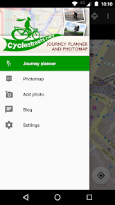
CycleStreets journey planner
3.0star
610 reviews
100K+
Downloads

PEGI 3
info

About this app
Plan routes from A to B anywhere in the UK, with a choice of routing modes to suit a range of cyclists from beginner through regular commuter to enthusiast. The Photomap lets you submit photos of infrastructure problems or good practice around the UK.
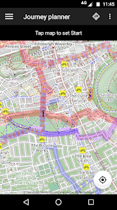
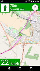
PLAN BIKE NAVIGATION FROM A TO B TO C
Select a start and finish point, plus intermediate waypoints, by tapping on the map, by searching for names/places/postcodes, or by using your current location, and tap to obtain the route. Uses the general street network, plus Sustrans and other routes.
CHOICE OF FOUR ROUTING MODES
The app produces routes that will suit most cyclists. It can optionally can find faster or quieter routes for different types of rider. Routes are fetched from the CycleStreets website.
HILLS? NO PROBLEM!
The journey planner knows about hills, and finds routes that take advantage of the descents and avoids the ascents where possible. It balances these against the available road types. The route can be displayed on a map with contours using the OpenCycleMap option.
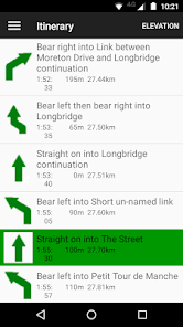
STAGE-BY-STAGE ITINERARY
As well as the main map view, planned routes are loaded into an itinerary view, so you can follow each part of the journey. The street name, time and length are all shown, as is a detailed map for each individual stage of the journey. Routes are saved so you can also follow them again later.
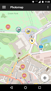
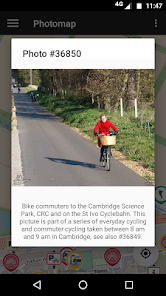
PHOTOMAP
The Photomap is a cycling advocacy tool used by campaign groups around the country. Use it to browse examples of problems or good practice, and add your own pictures. Need more cycle parking in your favourite spot in town? Sign in with a free account and add a photo of it to the Photomap.
OPENSTREETMAP
Routing makes use of OpenStreetMap data, the brilliant 'geo-wiki' to which you can contribute. Note that, at present, some areas of the country have better coverage than others. Streets and paths of all kinds, including Sustrans routes and Local Authority network, are included. Routing quality is being developed all the time, with new types of cycling and street data being added and interpreted by the route planner.
THANKS
Android App written by our great volunteers: Jez Higgins and Oliver Lockwood, with contributions from Christopher Fraser, Jonathan Gray, Theodore Hong, Farid Kurbanov, kyegupov, Shaun McDonald, Hilary Newmark, Simon Nuttall, John Singleton, Colin Watson.
Part of the development of this App has been funded by Cycling Scotland.
PLAN BIKE NAVIGATION FROM A TO B TO C
Select a start and finish point, plus intermediate waypoints, by tapping on the map, by searching for names/places/postcodes, or by using your current location, and tap to obtain the route. Uses the general street network, plus Sustrans and other routes.
CHOICE OF FOUR ROUTING MODES
The app produces routes that will suit most cyclists. It can optionally can find faster or quieter routes for different types of rider. Routes are fetched from the CycleStreets website.
HILLS? NO PROBLEM!
The journey planner knows about hills, and finds routes that take advantage of the descents and avoids the ascents where possible. It balances these against the available road types. The route can be displayed on a map with contours using the OpenCycleMap option.
STAGE-BY-STAGE ITINERARY
As well as the main map view, planned routes are loaded into an itinerary view, so you can follow each part of the journey. The street name, time and length are all shown, as is a detailed map for each individual stage of the journey. Routes are saved so you can also follow them again later.
PHOTOMAP
The Photomap is a cycling advocacy tool used by campaign groups around the country. Use it to browse examples of problems or good practice, and add your own pictures. Need more cycle parking in your favourite spot in town? Sign in with a free account and add a photo of it to the Photomap.
OPENSTREETMAP
Routing makes use of OpenStreetMap data, the brilliant 'geo-wiki' to which you can contribute. Note that, at present, some areas of the country have better coverage than others. Streets and paths of all kinds, including Sustrans routes and Local Authority network, are included. Routing quality is being developed all the time, with new types of cycling and street data being added and interpreted by the route planner.
THANKS
Android App written by our great volunteers: Jez Higgins and Oliver Lockwood, with contributions from Christopher Fraser, Jonathan Gray, Theodore Hong, Farid Kurbanov, kyegupov, Shaun McDonald, Hilary Newmark, Simon Nuttall, John Singleton, Colin Watson.
Part of the development of this App has been funded by Cycling Scotland.
Updated on
Safety starts with understanding how developers collect and share your data. Data privacy and security practices may vary based on your use, region, and age. The developer provided this information and may update it over time.

No data shared with third parties
Learn more about how developers declare sharing

This app may collect these data types
Location, Personal info, and Photos and videos

Data is encrypted in transit

You can request that data be deleted
Ratings and reviews
3.2
548 reviews

A Google user
- Flag inappropriate
November 20, 2019
This app version is really quite poor compared to previous versions. For a start, the default map pack switches to offline vector maps, and even if you change to open cycle maps in settings, it defaults to vector again on opening. Also, when pressing back button, you get the options semi imposed over the map in error. They really need a new version to fix asap.
4 people found this review helpful
CycleStreets Ltd
May 2, 2020
Hi Jonathan, we released an updated version to the Play store today (3.7). It should fix the issues you have described. If you have the time, would you mind downloading it and giving it a try, please? All feedback welcome.

Ed Pearce
- Flag inappropriate
May 20, 2022
Has had its glitches, but now works really well for me. Centring, finding places and visibility have all improved, though the green and pink lines can still be tricky to see in bright sunlight. Most of all, it gives great cycle routes, finding quiet, efficient ways to navigate around London. Has the edge on Citymapper and (cycle)streets ahead of Google Maps.
3 people found this review helpful

Gareth Davies
- Flag inappropriate
July 8, 2021
What a pity. Was my favourite app but after the latest Android update it doesn't display the map any more. This, coupled with problems with the previous update, mean that it's becoming very unreliable. Previously, it was really good, identifying a variety of possible routes and usually, though not always, avoiding death trap dual carriageways and the like.
23 people found this review helpful
CycleStreets Ltd
September 16, 2021
I'm sorry for the inconvenience. There are some breaking changes in recent Android versions (to do with storage access) which I believe to be the cause. We don't yet have an upgrade fix (I will update this review when that changes). As a workaround, if you uninstall and reinstall the application then the map display should work again.
What’s new
Fixed Comment on this Route so you can, indeed, send a comment.
Other small bug fixes.
Other small bug fixes.
App support
About the developer
CYCLESTREETS LIMITED
info@cyclestreets.net
ST JOHN'S INNOVATION CENTRE COWLEY ROAD
CAMBRIDGE
CB4 0WS
United Kingdom
+44 7723 219031


