
Earthquakes
Contains adsIn-app purchases
4.3star
2.79K reviews
500K+
Downloads

Everyone
info


About this app
Track earthquakes in real time! 🌍
This mobile app is designed for anyone who wants up-to-date information about earthquakes around the world. The app aggregates data from official sources: USGS, EMSC, and GeoNet.
Key Features:
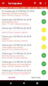
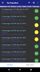
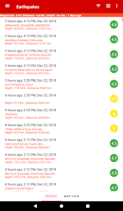
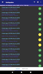
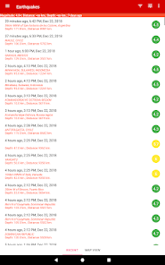
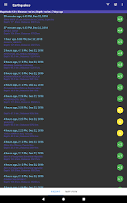
• 📋 List of recent earthquakes – shows the location, magnitude, and time of each event.
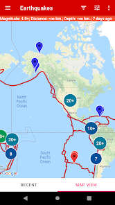
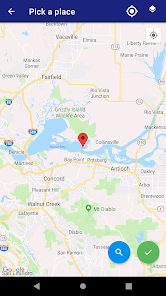
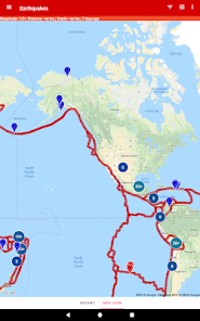
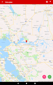
• 🗺 Interactive map – visual representation of earthquake distribution, with the option to display on a satellite map.
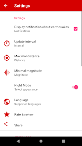
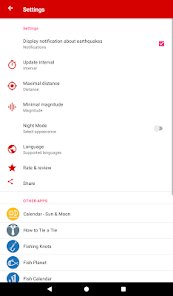
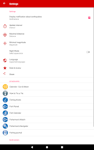
• 🔄 Filters – sort earthquakes by magnitude, depth, and distance from your current location.
• 🚨 Real-time alerts – receive notifications about new earthquakes. Alerts can be customized by magnitude and distance.
• 📊 Detailed information – depth, magnitude, intensity, and other characteristics of each earthquake.
• 🕰 Earthquake history – analyze the frequency and distribution of events over time.
• 🌐 Tectonic plate boundaries – evaluate hazardous and safe regions on the planet (The GEM Global Active Faults Database. Earthquake Spectra, vol. 36, no. 1_suppl, Oct. 2020, pp. 160–180, doi:10.1177/8755293020944182).
Who is this app for:
Scientists, geology enthusiasts, and anyone who wants to stay informed about seismic activity around the world.
Why choose this application:
A simple, informative, and visual app that helps you track earthquakes and stay safe.
This mobile app is designed for anyone who wants up-to-date information about earthquakes around the world. The app aggregates data from official sources: USGS, EMSC, and GeoNet.
Key Features:
• 📋 List of recent earthquakes – shows the location, magnitude, and time of each event.
• 🗺 Interactive map – visual representation of earthquake distribution, with the option to display on a satellite map.
• 🔄 Filters – sort earthquakes by magnitude, depth, and distance from your current location.
• 🚨 Real-time alerts – receive notifications about new earthquakes. Alerts can be customized by magnitude and distance.
• 📊 Detailed information – depth, magnitude, intensity, and other characteristics of each earthquake.
• 🕰 Earthquake history – analyze the frequency and distribution of events over time.
• 🌐 Tectonic plate boundaries – evaluate hazardous and safe regions on the planet (The GEM Global Active Faults Database. Earthquake Spectra, vol. 36, no. 1_suppl, Oct. 2020, pp. 160–180, doi:10.1177/8755293020944182).
Who is this app for:
Scientists, geology enthusiasts, and anyone who wants to stay informed about seismic activity around the world.
Why choose this application:
A simple, informative, and visual app that helps you track earthquakes and stay safe.
Updated on
Safety starts with understanding how developers collect and share your data. Data privacy and security practices may vary based on your use, region, and age. The developer provided this information and may update it over time.


Ratings and reviews
4.2
2.7K reviews

Kamila Balinska
- Flag inappropriate
July 22, 2025
Absolutely fantastic, good visuals in regards to earthquakes. 👍🏼👍🏼👍🏼
2 people found this review helpful

Bear Wandering (Bear)
- Flag inappropriate
July 30, 2025
an 8.8 and nothing shows on the app... complete fail.
2 people found this review helpful

Brendan Maher
- Flag inappropriate
- Show review history
October 11, 2021
List does not follow settings. Eg I select 7 days it shows 2 days. Tried several times... no change and I've paid for App. Useless.....
21 people found this review helpful
What’s new
• Notifications are now more reliable
• Iso-magnitude lines are now displayed on the map
• Iso-magnitude lines are now displayed on the map
App support
About the developer
Kirill Bychkov
kb.mobile.apps@gmail.com
NEKI LIBOHOVA, Nd.15
Durres 2004
Albania
undefined


