

GPS Field Area Measure : GLand
Contains adsIn-app purchases

4.3star
96.3K reviews
5M+
Downloads

Everyone
info


About this app
GLandMeasure is the ultimate land measurement app using GPS. Easily measure land area, calculate acreage, measure distances, define property boundaries, and survey fields with accuracy. Perfect for farmers, landowners, surveyors, and real estate professionals. Use this GPS area calculator to map your farm, measure property lines, analyze terrain, convert units, and export data in KML, GeoJSON, or CSV. Supports UTM, MGRS, DMS, and more. Whether you're managing fields or measuring plots, GLandMeasure is the all-in-one mapping and land survey tool you can trust.
Tired of inaccurate land estimates? GLandMeasure is your ultimate precision tool for all land surveying and GIS needs. Easily and quickly calculate areas, measure distances, determine perimeters, define property lines, and manage complex geospatial data with confidence.
Discover the Power of GLandMeasure:
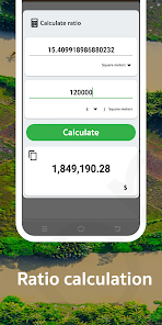
🌟 Accurate Area Calculator: Instantly find the area of any land, field, farm, lot, or property. Perfect for calculating acreage!
🛰️ GPS Land Measurement: Utilize high-precision GPS for reliable field area data, mapping, and boundary surveys.
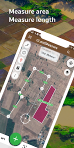
🚶 Measure Area by Walking: Simply walk the perimeter to map out exact boundaries – ideal for irregular shapes, paths, and paddock measurements!
📏 Easy Distance Tool: Quickly and conveniently calculate distances between points on your map or on-site.
🌐 Flexible Unit Converter: Effortlessly switch between various units: Acres, Square Feet (sq ft), Square Meters (sq m), Hectares (ha), Square Kilometers (sq km), Miles (mi), Kilometers (km), Feet (ft), Yards (yd), and more.
GLandMeasure is the Go-To App For:
Farmers & Agricultural Professionals: Manage farmland, measure field acreage, plan crops, and optimize resources.
Real Estate Agents, Appraisers & Developers: Confidently measure property sizes, verify lot dimensions, and enhance listings.
Land Surveyors, Engineers & GIS Professionals: Obtain reliable data for surveys, construction, environmental assessments, and GIS analysis.
Homeowners & Landowners: Accurately determine your property lines, plan landscaping or fencing projects.
Outdoor Enthusiasts & Planners: Measure trails, map out recreational areas, or plan construction layouts.
Advanced GIS & Surveying Capabilities:
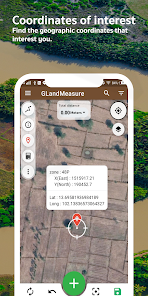
🌐 Multi-Coordinate System Support: Work seamlessly with various global and local coordinate systems including GEO (Latitude/Longitude), DMS (Degrees, Minutes, Seconds), UTM (Universal Transverse Mercator), MGRS (Military Grid Reference System), Geohash, and Plus Codes.
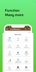
📤 Versatile Export & Sharing Options:
Share coordinates instantly.
Export your project data to KML, GeoJSON, Excel (CSV), and professional PDF reports.
⛰️ Elevation & Terrain Analysis:
Access altitude data for any point or area.
Visualize terrain with contour lines for better understanding of topography.
Calculate soil volume (cut and fill estimations) for earthworks and landscaping projects.
🌳 Area Analytics: Perform quick tree count estimations within measured areas for forestry or planning.
🌦️ Local Weather Forecast: Get on-the-spot weather predictions integrated for your surveyed location.
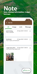
📍 Save & Manage Points of Interest: Easily save, label, and manage important locations, waypoints, or survey markers.
📸 GIS Camera: Capture georeferenced photos to document fieldwork, tag specific points of interest, and integrate visual data with your maps. (This assumes capturing photos with location data, not area measurement via camera view).
⏱️ Built-in GPS Speedometer: Ensures accurate tracking and data collection during walk measurements.
🗺️ Clear Satellite Map View: Provides excellent visual context for your measurements and planning.
Stop guessing. Start measuring with confidence! Download GLandMeasure today for the most comprehensive, user-friendly, and accurate solution for all your land, field, distance measurement, and GIS data needs!
Tired of inaccurate land estimates? GLandMeasure is your ultimate precision tool for all land surveying and GIS needs. Easily and quickly calculate areas, measure distances, determine perimeters, define property lines, and manage complex geospatial data with confidence.
Discover the Power of GLandMeasure:
🌟 Accurate Area Calculator: Instantly find the area of any land, field, farm, lot, or property. Perfect for calculating acreage!
🛰️ GPS Land Measurement: Utilize high-precision GPS for reliable field area data, mapping, and boundary surveys.
🚶 Measure Area by Walking: Simply walk the perimeter to map out exact boundaries – ideal for irregular shapes, paths, and paddock measurements!
📏 Easy Distance Tool: Quickly and conveniently calculate distances between points on your map or on-site.
🌐 Flexible Unit Converter: Effortlessly switch between various units: Acres, Square Feet (sq ft), Square Meters (sq m), Hectares (ha), Square Kilometers (sq km), Miles (mi), Kilometers (km), Feet (ft), Yards (yd), and more.
GLandMeasure is the Go-To App For:
Farmers & Agricultural Professionals: Manage farmland, measure field acreage, plan crops, and optimize resources.
Real Estate Agents, Appraisers & Developers: Confidently measure property sizes, verify lot dimensions, and enhance listings.
Land Surveyors, Engineers & GIS Professionals: Obtain reliable data for surveys, construction, environmental assessments, and GIS analysis.
Homeowners & Landowners: Accurately determine your property lines, plan landscaping or fencing projects.
Outdoor Enthusiasts & Planners: Measure trails, map out recreational areas, or plan construction layouts.
Advanced GIS & Surveying Capabilities:
🌐 Multi-Coordinate System Support: Work seamlessly with various global and local coordinate systems including GEO (Latitude/Longitude), DMS (Degrees, Minutes, Seconds), UTM (Universal Transverse Mercator), MGRS (Military Grid Reference System), Geohash, and Plus Codes.
📤 Versatile Export & Sharing Options:
Share coordinates instantly.
Export your project data to KML, GeoJSON, Excel (CSV), and professional PDF reports.
⛰️ Elevation & Terrain Analysis:
Access altitude data for any point or area.
Visualize terrain with contour lines for better understanding of topography.
Calculate soil volume (cut and fill estimations) for earthworks and landscaping projects.
🌳 Area Analytics: Perform quick tree count estimations within measured areas for forestry or planning.
🌦️ Local Weather Forecast: Get on-the-spot weather predictions integrated for your surveyed location.
📍 Save & Manage Points of Interest: Easily save, label, and manage important locations, waypoints, or survey markers.
📸 GIS Camera: Capture georeferenced photos to document fieldwork, tag specific points of interest, and integrate visual data with your maps. (This assumes capturing photos with location data, not area measurement via camera view).
⏱️ Built-in GPS Speedometer: Ensures accurate tracking and data collection during walk measurements.
🗺️ Clear Satellite Map View: Provides excellent visual context for your measurements and planning.
Stop guessing. Start measuring with confidence! Download GLandMeasure today for the most comprehensive, user-friendly, and accurate solution for all your land, field, distance measurement, and GIS data needs!
Updated on
Safety starts with understanding how developers collect and share your data. Data privacy and security practices may vary based on your use, region, and age. The developer provided this information and may update it over time.

This app may share these data types with third parties
Location

No data collected
Learn more about how developers declare collection

Data isn’t encrypted

You can request that data be deleted
Ratings and reviews
4.3
95K reviews

Adhi Paryono
- Flag inappropriate
February 13, 2025
Good and useful especially you can measure using your phone as gps marker. However, for using google maps, the marker can not be accurate, it move a bit from the point I set it to be. So the measurement can be quite far off, for instance, comparing with actual land measure, the difference is 48 meter square. Pls improve the marker accuracy and I' add one more star.
13 people found this review helpful

Benedict James
- Flag inappropriate
March 18, 2025
You actually have a good app... performance wise....but why is it that ...it is so difficult to delete the previous works...which may no longer be wanted. Infact the word "delete" does not even exist in the whole application. Pls look into this...or tell us the other way of doing it.
4 people found this review helpful

Sanan Khan
- Flag inappropriate
August 9, 2022
Very awesome.. I used it a lot and got great results.. But one thing that I think is very important to have to make this application more efficient.. When I set it to walk mode and measure it, manually placing a dot on the place to turn. If it is replaced by dots automatically, it will prove to be quite useful. I hope you will solve it as soon..
387 people found this review helpful
What’s new
Welcome to GLandMeasure version 3, the new edition!!! Community
Land measurement and length calculation made easier by dragging coordinates.
Share and forward information to social media such as Facebook and others. For example, posting real estate for sale.
Added functions: import KML, calculate land volume, measure land elevation, calculate trees, added image layer.
Add points of interest.
Separate project creation
Camera added to the app.
Added GeoJson, Geohash.
App support
About the developer
AUTHAI YAPRASAT
toptoshirou3@gmail.com
144 Tha Kasem
muang
สระแก้ว
Thailand
undefined


