Doppler storm radar - eMap HDF
Contains adsIn-app purchases
4.5star
5.7K reviews
100K+
Downloads

Everyone
info


About this app
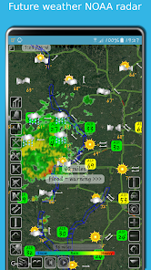
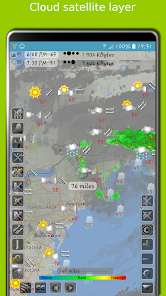
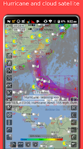
eMap HDF is a high-resolution predictive NOAA Doppler storm radar with a weather map.
The weather app has the next layers provided by the National Weather Service (NWS) & NOAA:
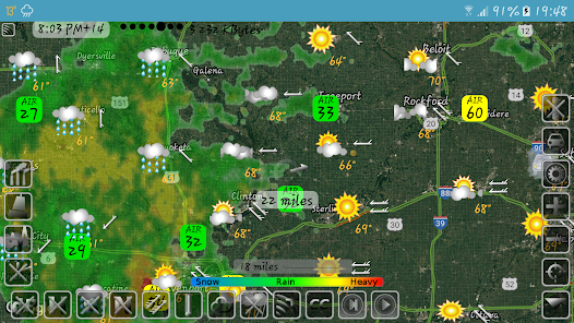
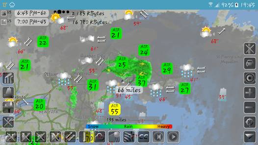
- Snow and rain radar
- Severe weather alerts, tornado tracker, heavy rain and wind alerts
- Lightning strike map
- Cloud satellite layer
Worldwide layers:
- Typhoon (tropical storm, cyclone) and hurricane tracker provided by GDACS
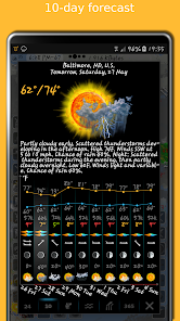
- Accurate weather forecast for 10 days
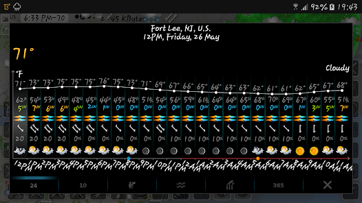
- Hourly weather forecast for 24 hours
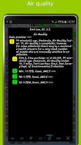
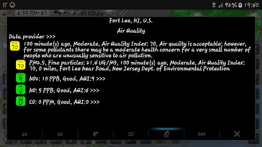
- Air quality and air pollution
- Earthquake map
- Temperature map
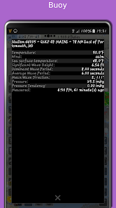
- Sea temperature based on measurements from buoys and satellites
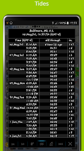
- Tide charts
- Local time in each city
- Number of residents in cities
- Road traffic
- Buoys
- Dew point
- Humidity
- Wind map
The storm radar app calculates a one-hour prediction of rain and snow in five-minute frames. NOAA radar has a six-hour weather radar history.
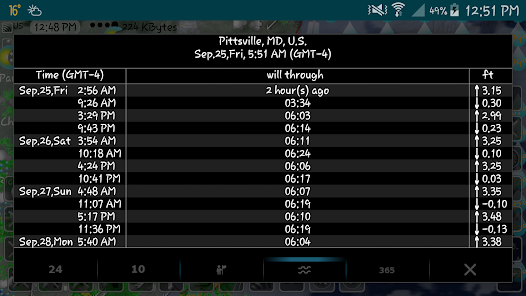
Tide times are for over 10,000 tidal stations in the US, UK, Canada, etc. with forecasts for several months. The app follows the current location and shows the tides near me.
The earthquake app includes earthquakes filtered by magnitude and depth. Earthquake tracker data is provided by the USGS.
The distance measurement tool shows the distance between two points in miles and kilometres.
The air quality app includes concentrations of ozone (O3), fine (PM25) and coarse (PM10), particulate matter, dioxide (NO2) and nitrogen oxide (NO), carbon monoxide (CO), etc. from various sources: AirNow, Copernicus, ECMWF, etc.
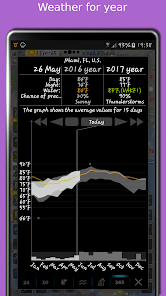
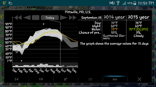
With the Doppler radar app, you can long-click on any location on the map and see the weather at that location with the archive for the last few years. The archive includes sea and air temperature, precipitation and cloud cover. Travel weather helps you choose the right time and place for your upcoming trip and compare temperatures and precipitation between this year and past years.
If you click on the "CC" button and toggle to "10" or "24", you can view a 10-day or 24-hour forecast directly on the map.
eMap HDF shows road traffic. The forecast includes not only temperature and precipitation, but also humidity, wind speed and direction, dew point, visibility on the roads feels like temperature.
As the data published in eMap HDF is not subject to use on the voyage, please do not use it for navigation.
The weather app has the next layers provided by the National Weather Service (NWS) & NOAA:
- Snow and rain radar
- Severe weather alerts, tornado tracker, heavy rain and wind alerts
- Lightning strike map
- Cloud satellite layer
Worldwide layers:
- Typhoon (tropical storm, cyclone) and hurricane tracker provided by GDACS
- Accurate weather forecast for 10 days
- Hourly weather forecast for 24 hours
- Air quality and air pollution
- Earthquake map
- Temperature map
- Sea temperature based on measurements from buoys and satellites
- Tide charts
- Local time in each city
- Number of residents in cities
- Road traffic
- Buoys
- Dew point
- Humidity
- Wind map
The storm radar app calculates a one-hour prediction of rain and snow in five-minute frames. NOAA radar has a six-hour weather radar history.
Tide times are for over 10,000 tidal stations in the US, UK, Canada, etc. with forecasts for several months. The app follows the current location and shows the tides near me.
The earthquake app includes earthquakes filtered by magnitude and depth. Earthquake tracker data is provided by the USGS.
The distance measurement tool shows the distance between two points in miles and kilometres.
The air quality app includes concentrations of ozone (O3), fine (PM25) and coarse (PM10), particulate matter, dioxide (NO2) and nitrogen oxide (NO), carbon monoxide (CO), etc. from various sources: AirNow, Copernicus, ECMWF, etc.
With the Doppler radar app, you can long-click on any location on the map and see the weather at that location with the archive for the last few years. The archive includes sea and air temperature, precipitation and cloud cover. Travel weather helps you choose the right time and place for your upcoming trip and compare temperatures and precipitation between this year and past years.
If you click on the "CC" button and toggle to "10" or "24", you can view a 10-day or 24-hour forecast directly on the map.
eMap HDF shows road traffic. The forecast includes not only temperature and precipitation, but also humidity, wind speed and direction, dew point, visibility on the roads feels like temperature.
As the data published in eMap HDF is not subject to use on the voyage, please do not use it for navigation.
Updated on
Safety starts with understanding how developers collect and share your data. Data privacy and security practices may vary based on your use, region, and age. The developer provided this information and may update it over time.


Ratings and reviews
4.6
4.98K reviews

donnie spiller
- Flag inappropriate
- Show review history
August 16, 2025
extremely intrinsic and detailed information in regards to weather. easy to navigate beautiful UI. I can't think of another weather app that does so much as this one and I have tried all of them. however, there is one downside. for an unapparent reason you can't purchase the option of removing ads. so, a lot of the premium options are not available. still, the app is worth having and is highly recommended

Jay Eiger
- Flag inappropriate
August 15, 2021
Absolutely the best weather app of them all. Excellent customer service. You have to invest some time to lean what all the buttons do, but it is well worth the effort. I found that if you want the most accurate future radar (by pressing the radar button until you see the plus sign overlay the button), you have to zoom way in on your location, like + - 1 mile. The future radar updates every 10 mnutes, and the time (top left) shows you when that happens wih a + - minutes.
39 people found this review helpful
Elecont software
August 16, 2021
Thanks. We will make our radar app even more accurate and convenient.

Lok Phone
- Flag inappropriate
March 28, 2022
Another great app from Elecont, like a sibling of eWeather. This app is map-forward (centric), with tons of selections to show on the map. These different selections can be enabled and disabled with buttons on the map screen (with a nice tool tip that appears when clicking an icon to let you know what you've enabled/disabled/ changed. You can also go to the options menu to check or unchecked the options from a list. Forecast data can be accessed by holding down on a map location. Kudos!
15 people found this review helpful
Elecont software
March 31, 2022
Thank you. We still have a lot of ideas for adding new interesting data to our weather map app.
What’s new
Edge-to-edge display function
Some bugs fixed
User interface improved
Some bugs fixed
User interface improved
App support
About the developer
Сергей Барвиненко
elecontsoftware@gmail.com
ул. Савушкина, дом 54
71
Санкт-Петербург
Russia
197183
undefined


