Iphigénie - offline maps
In-app purchases
4.4star
8.47K reviewsinfo
1M+
Downloads

PEGI 3
info


About this app
Iphigénie is the hiking map app for outdoor enthusiasts in France and around the world. Perfect for individuals (hikers, trailers, bikers, horse riders…) and professionals (guides, firefighters, surveyors, airmen, sailors, etc.) who need accurate maps.
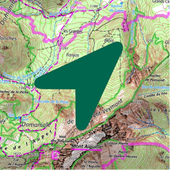
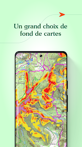
Find more than 40 detailed topographic basemaps (including IGN maps, SwissTopo, IGN Spain, OpenTopo, OpenSnow, land registry, slope inclination), even while offline.
BEFORE YOUR OUTING
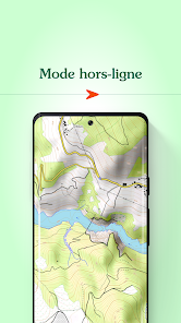
- Prepare your outing by downloading maps to access them offline
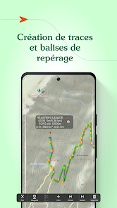
- Create, edit and import tracks
- Create and import markers (e.g. mushroom spots, departure points of routes, etc.)
- Print sections of the map if you need to
- Search for a specific location by name or by GPS details
- Access routes or landmarks from IGNRando or Data-Avalanche
- Access a 3D view and slope inclinations
DURING YOUR OUTING
- Geolocate yourself on the basemap of your choice
- Follow routes using GPS, without worrying about network availability
- Record your track
- Access real-time information such as distance traveled, elevation (±), average speed, current speed, estimated time of arrival, etc.
- Activate the beacon function to allow your loved ones to follow your progress in real-time
- Create specific voice alerts to guide you, even with your iPhone in your pocket
AFTER YOUR OUTING
- Create groups of tracks/landmarks
- Store and backup all your data in the Cloud
- Export your GPS tracks and landmarks in GPX format
- Share your outings and landmarks with all your friends
Download the free basic app
Download the basic application for free on your smartphone. This version allows you to be geolocated on one of the 25 free base maps such as Open Topo Map, Open Cycle Map, Open Snow map. The world is within reach!
You will also have access to real-time information such as your position/course/altitude/speed.
Use the complete app with the “Iphigénie Carto” subscription
The Iphigénie Carto subscription is €24.99 per year. It gives you access to 40 base maps including those of IGN. These maps can be downloaded on your device (iPhone, iPad, iPod, Watch) so that you can access them even without a network.
You also have access to the full potential of Iphigénie by finding all the features mentioned above.
Good to know: you have 7 days to test the complete app for free.
Use the high quality Italian map with the ‘Maps of the Italian Alps’ subscription
You can buy Fraternali's 1:25,000 Italian topographic maps for €24.99 a year. This subscription gives you access to accurate, information-packed digital maps covering the western Italian Alps.
List of available maps:
- IGN France
- SwissTopo
- Fraternali
- IGN Spain
- IGN Belgium
- BKG Germany
- Kartverket Norway
- Cartographic Institute of Catalunya
- OpenTopo
- OpenCycle
- OpenSnow
- ICAO
- ESRI
- Satellite view
- Cadastre
- Slope inclination
- Restricted areas for drones
- Historical maps of France
- Geological and mining maps (France)
- National Forestry Office
We donate 1% of our turnover to 1% for the Planet to help preserve the environment.
MADE IN FRANCE
Find more than 40 detailed topographic basemaps (including IGN maps, SwissTopo, IGN Spain, OpenTopo, OpenSnow, land registry, slope inclination), even while offline.
BEFORE YOUR OUTING
- Prepare your outing by downloading maps to access them offline
- Create, edit and import tracks
- Create and import markers (e.g. mushroom spots, departure points of routes, etc.)
- Print sections of the map if you need to
- Search for a specific location by name or by GPS details
- Access routes or landmarks from IGNRando or Data-Avalanche
- Access a 3D view and slope inclinations
DURING YOUR OUTING
- Geolocate yourself on the basemap of your choice
- Follow routes using GPS, without worrying about network availability
- Record your track
- Access real-time information such as distance traveled, elevation (±), average speed, current speed, estimated time of arrival, etc.
- Activate the beacon function to allow your loved ones to follow your progress in real-time
- Create specific voice alerts to guide you, even with your iPhone in your pocket
AFTER YOUR OUTING
- Create groups of tracks/landmarks
- Store and backup all your data in the Cloud
- Export your GPS tracks and landmarks in GPX format
- Share your outings and landmarks with all your friends
Download the free basic app
Download the basic application for free on your smartphone. This version allows you to be geolocated on one of the 25 free base maps such as Open Topo Map, Open Cycle Map, Open Snow map. The world is within reach!
You will also have access to real-time information such as your position/course/altitude/speed.
Use the complete app with the “Iphigénie Carto” subscription
The Iphigénie Carto subscription is €24.99 per year. It gives you access to 40 base maps including those of IGN. These maps can be downloaded on your device (iPhone, iPad, iPod, Watch) so that you can access them even without a network.
You also have access to the full potential of Iphigénie by finding all the features mentioned above.
Good to know: you have 7 days to test the complete app for free.
Use the high quality Italian map with the ‘Maps of the Italian Alps’ subscription
You can buy Fraternali's 1:25,000 Italian topographic maps for €24.99 a year. This subscription gives you access to accurate, information-packed digital maps covering the western Italian Alps.
List of available maps:
- IGN France
- SwissTopo
- Fraternali
- IGN Spain
- IGN Belgium
- BKG Germany
- Kartverket Norway
- Cartographic Institute of Catalunya
- OpenTopo
- OpenCycle
- OpenSnow
- ICAO
- ESRI
- Satellite view
- Cadastre
- Slope inclination
- Restricted areas for drones
- Historical maps of France
- Geological and mining maps (France)
- National Forestry Office
We donate 1% of our turnover to 1% for the Planet to help preserve the environment.
MADE IN FRANCE
Updated on
Safety starts with understanding how developers collect and share your data. Data privacy and security practices may vary based on your use, region, and age. The developer provided this information and may update it over time.


Ratings and reviews
4.4
8K reviews

Cecile Lassalle
- Flag inappropriate
December 1, 2024
Very good map application that I have been using for years for hiking, ski touring and mountaineering. I have both the phone and laptop application (the latter is more convenient for planning). It takes a bit of time to get used to the app but then the possibilities are endless. I rate the app 4/5 bc lately I did notice some issues with the tracks when off network, and unfortunately the tiles downloading option is extremely slow.
3 people found this review helpful
Iphigénie
December 2, 2024
Bonjour, merci pour votre retour, nous prenons en considération vos remarques.
Cordialement.
Stevens

Justė Gaižutytė
- Flag inappropriate
July 3, 2022
I have been using this app before, main function is great - topo maps! But navigation in your app is horrible, the dashboard panel is hard to understand.. now app is not working for me, i assume i need to pay licence, i cannot even find where to buy it!! I advise you too make it more user friendly and intituitive.. I rather use web version than app
10 people found this review helpful
Iphigénie
July 13, 2022
Hi Justė, thank you for using our app. We have been hard at work this year updating & improving the menus, to make them easy to use. When you wrote your review we had already released the first big set of changes to the world but it seems your phone had not automatically updated the app yet. Please try the new version & tell us what you think :-)

A Google user
- Flag inappropriate
- Show review history
April 23, 2019
Good enought. It does the job, map are ok when you paid the 15€. The focus is juste really big and ugly, why don't you just put a red dot on the map? You can't load GPX file , you have to pay again 5€ more to have something called Amax or Vmax, it's not very clear... Finally it's absolutely not user friendly... You have to be an IT engeneer to understand what it can do. Though it seems to be very powerfull and plenty of functionnality. That harder is to find, what are those functionnalities. But it's ok to hike when no network coverrage. edit: impossible to transfert application from an android terminal to a new one. Ask the support for help, but not very helpfull.
11 people found this review helpful
Iphigénie
April 24, 2019
Hi
We would be pleased to help you in iPhiGéNie's discovery. Feel free to contact us (aide.iphigenie(at)gmail.com)
What’s new
The map catalog is evolving.
A new OpenStreetMap basemap is now available.
OpenCycleMap maps have been removed.
A new OpenStreetMap basemap is now available.
OpenCycleMap maps have been removed.
App support
About the developer
IPHIGENIE
support@iphigen.ie
289 CHE DU CLOS DU SAVOY
74400 CHAMONIX-MONT-BLANC
France
+33 7 81 28 67 52


