
hittaut
Contains ads
1.7star
878 reviewsinfo
100K+
Downloads

PEGI 3
info
About this app
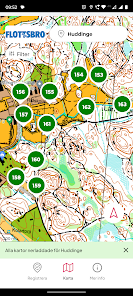
Search for checkpoints and explore your surroundings with Hittaut
Hittaut is a free recreational activity in Sweden. Grab a map and find your way to checkpoints.
• The map can be found on paper or in Hittaut’s app.
• Accessible in urban areas and nearby forests.
• Choose which checkpoints you want to visit and in what order.
• Unsure of your orienteering skills? Don’t worry – there are checkpoints in four different difficulty levels. Start with green, and you can get help from your GPS.
• Some checkpoints are accessible with a stroller, wheelchair, permobil, walker, bike etc.
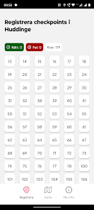
• Create an account and register your checkpoint visits.
• Challenge a friend, colleague or relative and follow the results in top lists.
• The length of the Hittaut season varies from place to place but is at least including the summer.
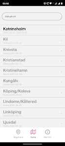
Hittaut is available in nearly 100 places around Sweden. Visit Hittaut online at: www.orientering.se/hittaut
Hittaut is a free recreational activity in Sweden. Grab a map and find your way to checkpoints.
• The map can be found on paper or in Hittaut’s app.
• Accessible in urban areas and nearby forests.
• Choose which checkpoints you want to visit and in what order.
• Unsure of your orienteering skills? Don’t worry – there are checkpoints in four different difficulty levels. Start with green, and you can get help from your GPS.
• Some checkpoints are accessible with a stroller, wheelchair, permobil, walker, bike etc.
• Create an account and register your checkpoint visits.
• Challenge a friend, colleague or relative and follow the results in top lists.
• The length of the Hittaut season varies from place to place but is at least including the summer.
Hittaut is available in nearly 100 places around Sweden. Visit Hittaut online at: www.orientering.se/hittaut
Updated on
Safety starts with understanding how developers collect and share your data. Data privacy and security practices may vary based on your use, region, and age. The developer provided this information and may update it over time.

No data shared with third parties
Learn more about how developers declare sharing

This app may collect these data types
Personal info

Data is encrypted in transit

You can request that data be deleted
Ratings and reviews
1.8
838 reviews

Karol Sierszeń
- Flag inappropriate
- Show review history
May 14, 2024
Works, but that's it. I use it only for registering points. Almost no configuration options. What makes it almost unusable is the fact that every single time I open the app, the whole map is downloaded again, it seems like it is deleted upon closure. The map seems to be not segmented, so zooming in causes the WHOLE map to be downloaded. Using online map from orientering.se is way more comfortable.
2 people found this review helpful

Mau Sortica
- Flag inappropriate
- Show review history
May 5, 2024
The older version of the app was better. Now it wastes several minutes dowloading the map, and it does it all the time.
3 people found this review helpful

Kent Solgule
- Flag inappropriate
- Show review history
June 20, 2022
Great app for the intended use. I would like to have the option to use standard symbols for posts (circles) and draw lines between. Intended use is: viewing orienteering maps around cities included in the project. You're not supposed to use the GPS, except if you are totally lost. The background map is a general purpose map (not intended for orienteering) based on OpenStreetMap (OSM) which is a community based mapping project. If no one is mapping an area the OSM is empty or not up to date.
1 person found this review helpful
Svenska orienteringsförbundet
October 27, 2022
Tack för din feedback
What's new
We continue to improve the experience for our users. Among other things, we have made improvements to the background downloading of maps. In addition, we have made some minor bug fixes that we hope will improve your experience.


