
WeTrek (ex IGNrando')
In-app purchases
3.4star
4.57K reviews
500K+
Downloads

Everyone
info

About this app
WeTrek is a platform for sharing routes and points of interest (POIs) related to outdoor activities.
MAPS & LAYERS IN FREE ACCESS (with internet connection)
• Plan IGN: most updated map, suitable for all activities
• Aerial photos (IGN)
• OpenStreetMap Outdoors: world map with hiking routes & contour lines
• OpenCycleMap: world map with cycling routes & contour lines
• Spain IGN map
• Swisstopo map
• Emergency calls (112) mobile network coverage map for France
• OpenSnowMap
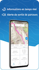
GPS GUIDING ALONG ROUTES
• See your progression on the altitude graph
• Get alerted if you exit the route
GPS TRACKING AND DATA CREATION
• Record your own routes with GPS tracking
• Quickly create routes on-device with the automatic routing tool that follows roads and paths (online only, with subscription)
• Create Points of interest
• Backup your route on the WeTrek platform
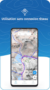
OFFLINE USE
• The GPS keeps working even without internet: see your position on the map, use GPS guiding and record routes
• Downloaded routes: descriptions, photos and guiding remain accessible
• Downloaded maps (with subscription)
Useful tip: Enabling Airplane Mode or disabling Mobile Data improves battery life, without affecting the Location Services (GPS)
WETREK PLUS SUBSCRIPTION
• Create routes with pedestrian and vehicle routing
• View & download the following maps & layers:
∙ All free version maps
∙ IGN maps (various scales)
∙ IGN 1:25k topo maps (Top 25): the famous French topographical maps available at all zoom levels
∙ 1950 IGN maps
∙ Military maps (1820-1866)
∙ ICAO aeronautical charts
∙ France mobile network operators coverage maps
∙ Slopes > 30° (useful for winter activites)
∙ Cadastral parcels layer
∙ DFCI grid (forest fire protection grid)
• Drones flight restriction areas
∙ Roads & paths layer (only available with Aerial photos)
Play Store subscription
• Linked to Google account
• Automatic renewal unless cancelled at least 24 hours before the end of the current period
• Auto-renewal may be turned off after purchase
Ubicarta store subscription
• Linked to your Ubicarta account
• Purchase & manage your subscription on wetrek.ubicarta.com
• Can be used on 3 devices at the same time (Android & iOS)
Use an SD card to store your data
Free space on your device.
——————————————————————
The app uses your network connection to stream maps or to download content or maps. Carrier charges may apply.
The app uses your device location to display it on the map, to record tracks and to share it to your friends.
Got ideas to improve WeTrek?
Write us on: support@wetrek.app
MAPS & LAYERS IN FREE ACCESS (with internet connection)
• Plan IGN: most updated map, suitable for all activities
• Aerial photos (IGN)
• OpenStreetMap Outdoors: world map with hiking routes & contour lines
• OpenCycleMap: world map with cycling routes & contour lines
• Spain IGN map
• Swisstopo map
• Emergency calls (112) mobile network coverage map for France
• OpenSnowMap
GPS GUIDING ALONG ROUTES
• See your progression on the altitude graph
• Get alerted if you exit the route
GPS TRACKING AND DATA CREATION
• Record your own routes with GPS tracking
• Quickly create routes on-device with the automatic routing tool that follows roads and paths (online only, with subscription)
• Create Points of interest
• Backup your route on the WeTrek platform
OFFLINE USE
• The GPS keeps working even without internet: see your position on the map, use GPS guiding and record routes
• Downloaded routes: descriptions, photos and guiding remain accessible
• Downloaded maps (with subscription)
Useful tip: Enabling Airplane Mode or disabling Mobile Data improves battery life, without affecting the Location Services (GPS)
WETREK PLUS SUBSCRIPTION
• Create routes with pedestrian and vehicle routing
• View & download the following maps & layers:
∙ All free version maps
∙ IGN maps (various scales)
∙ IGN 1:25k topo maps (Top 25): the famous French topographical maps available at all zoom levels
∙ 1950 IGN maps
∙ Military maps (1820-1866)
∙ ICAO aeronautical charts
∙ France mobile network operators coverage maps
∙ Slopes > 30° (useful for winter activites)
∙ Cadastral parcels layer
∙ DFCI grid (forest fire protection grid)
• Drones flight restriction areas
∙ Roads & paths layer (only available with Aerial photos)
Play Store subscription
• Linked to Google account
• Automatic renewal unless cancelled at least 24 hours before the end of the current period
• Auto-renewal may be turned off after purchase
Ubicarta store subscription
• Linked to your Ubicarta account
• Purchase & manage your subscription on wetrek.ubicarta.com
• Can be used on 3 devices at the same time (Android & iOS)
Use an SD card to store your data
Free space on your device.
——————————————————————
The app uses your network connection to stream maps or to download content or maps. Carrier charges may apply.
The app uses your device location to display it on the map, to record tracks and to share it to your friends.
Got ideas to improve WeTrek?
Write us on: support@wetrek.app
Updated on
Safety starts with understanding how developers collect and share your data. Data privacy and security practices may vary based on your use, region, and age. The developer provided this information and may update it over time.


Ratings and reviews
3.6
4.37K reviews

Mike Taylor
- Flag inappropriate
August 8, 2025
I used this app daily while hiking in france It's not as good as Ordnance Survey, but it's a good app. The navigation / user experience is a little clunky. There's a good selection of user contributed trails (I think you can only create these by recording, I couldn't figure it out), the filtering on the selection is a little wild. But I wouldn't go hiking without it! Vive le IGN !
Ubicarta
August 12, 2025
Thank you for your feedback and happy to hear you've been enjoying our app. We'll make sure to keep on upgrading it and hopefully one day can earn your 5 stars ;)

Bon Jour
- Flag inappropriate
- Show review history
January 19, 2025
On the free trial. I have the full 1- 25000 on my phone from a different source so I might no subscribe, however I think it's a fair price. This has a lot richer look to it and if I didn't already have the full map I would snap this up, it looks like a great piece of kit. So, decided to subscribe but will not process the payment. Been trying for a week at least. Is it you or Google that the issue is with ?
3 people found this review helpful
Ubicarta
January 20, 2025
Thank you for your good words and sorry to hear you've been facing some trouble subscribing. Please feel free to reach out so we can help you out : ignrando@ubicarta.com

Frank Schweppe
- Flag inappropriate
- Show review history
December 4, 2021
I used ViewRanger, which was an excellent app to get access to downloaded offline IGN maps (the whole social network buddy stuff does not interest me at all but that's OK, you don't need to use it). Unfortunately ViewRanger is no more, sold out to another app that is worse. IGN Rando is the obvious one to use instead. Have downloaded it but use will be limited until the possibility to download maps on an SD card becomes available. For anyone designing ths kind of software, do realize that just where you need topo maps, in the outdoors, connection to a 4G data network is often bad or non existent. So you really need preloaded maps of a fairly large area, and that is just too much data for the phone's internal memory (unless you have a very expensive phone with huge internal storage, and even then, if you also need to store pictures and videos etc. there, it still fills up). Keeping maps on an SD card is way better. Once it has that option I'll give it more stars...
19 people found this review helpful
Ubicarta
December 6, 2021
Thank you for your message Frank.
Saving maps on an SD card is already available in the beta version of the app, and it will be available in the normal version by the end of the week. You can contact us at ignrando@ubicarta.com if needed. Kind regards.
What’s new
• Welcome to WeTrek! Some missing feature will be restored in the following weeks.
App support
About the developer
Ubicarta
contact@ubicarta.com
89 T RUE LOUIS LAVERNY
33130 BEGLES
France
+33 7 61 02 28 45


