
Trail Sense
4.7star
1.08 ألف مراجعة
+100 ألف
عملية تنزيل

الجميع
info
لمحة عن هذا التطبيق
استكشف ما هو أبعد من الإنترنت باستخدام Trail Sense.
- مصممة للمشي لمسافات طويلة وحقائب الظهر والتخييم والجيوكاشينغ
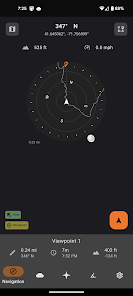
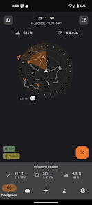
- وضع المنارات والانتقال إليها
- الاستخدام كبوصلة (متوفر فقط على الأجهزة التي تحتوي على مستشعر بوصلة)
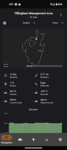
- اتبع المسارات
- تتبع خطواتك مع التراجع
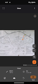
- استخدم الصورة كخريطة
- خطط لما يجب أن تحزمه
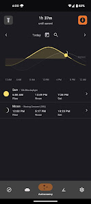
- يتم تنبيهك قبل غروب الشمس
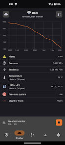
- التنبؤ بالطقس (متوفر فقط على الأجهزة التي تحتوي على مستشعر البارومتر)
- استخدم هاتفك كمصباح كهربائي
- وأكثر بكثير!
Trail Sense هي أداة، وكما هو الحال مع أي أداة أخرى تجلبها إلى البرية، من الضروري أن يكون لديك معدات ومهارات احتياطية. هذا التطبيق مخصص لأغراض المعلومات فقط ويتم تحديد دقة التنبؤات وأجهزة الاستشعار من خلال عدد من العوامل، بما في ذلك المعايرة وجودة المستشعر والمصادر الخارجية وما إلى ذلك. استخدمه على مسؤوليتك الخاصة، وامتلك دائمًا أدوات احتياطية (مثل البوصلة) ، وابقَ آمنًا.
هذا التطبيق أيضًا لا يستخدم الإنترنت ولن يستخدمه أبدًا - جميع المعلومات الموجودة في Trail Sense تأتي مباشرة من أجهزة استشعار هاتفك، ولن تترك أي بيانات Trail Sense.
مشاكل شائعة
- عدم وجود بوصلة: إذا لم يكن هاتفك مزودًا بمستشعر بوصلة، فلا يمكنني فعل أي شيء لجعله يعمل لأن هذا مجرد جهاز. سيظل بإمكانك استخدام ميزات أخرى في Trail Sense.
- لا يوجد طقس: أداة الطقس متاحة فقط إذا كان هاتفك مزودًا بمستشعر البارومتر.
هل وجدت مشكلة أو تريد ميزة جديدة؟ اتصل بي على Trailsense@protonmail.com أو أنشئ مشكلة جديدة على GitHub: github.com/kylecorry31/Trail-Sense
أنا المطور الوحيد لـ Trail Sense، لذا سأبذل قصارى جهدي للمساعدة في حل المشكلات - ولكن لدي مجموعة محدودة من الأجهزة للاختبار عليها.
الأذونات
- الإخطارات: يسمح لـ Trail Sense بعرض الإشعارات (التراجع، الطقس، تنبيهات غروب الشمس، أحداث علم الفلك، مؤقت غليان الماء، إلخ)
- الموقع: يسمح لـ Trail Sense باسترداد موقعك للملاحة والطقس (معايرة مستوى سطح البحر) وعلم الفلك.
- موقع الخلفية: يسمح لـ Trail Sense باسترداد موقعك لتنبيهات غروب الشمس أثناء وجوده في الخلفية. في بعض الأجهزة، سيؤدي ذلك أيضًا إلى تحسين موثوقية تتبع المسار ومراقبة الطقس.
- النشاط البدني: يسمح لـ Trail Sense باستخدام عداد الخطى في هاتفك لحساب المسافة.
- الكاميرا: يتيح لـ Trail Sense استخدام الكاميرا الخاصة بك على بوصلة الرؤية ومقياس الميل ولالتقاط الصور التي يستخدمها Cloud Scanner وQR Code Scanner وخرائط الصور.
- الإنذارات والتذكيرات: يسمح لـ Trail Sense بنشر إشعار في الوقت المحدد. يتم استخدام ذلك بواسطة أداة الساعة (عند تحديث وقت النظام) وتنبيهات غروب الشمس.
الروابط
سياسة الخصوصية: https://kylecorry.com/Trail-Sense/#privacy
الأسئلة الشائعة: https://github.com/kylecorry31/Trail-Sense#faq
يتوفر Trail Sense بموجب ترخيص MIT: https://opensource.org/license/mit/
- مصممة للمشي لمسافات طويلة وحقائب الظهر والتخييم والجيوكاشينغ
- وضع المنارات والانتقال إليها
- الاستخدام كبوصلة (متوفر فقط على الأجهزة التي تحتوي على مستشعر بوصلة)
- اتبع المسارات
- تتبع خطواتك مع التراجع
- استخدم الصورة كخريطة
- خطط لما يجب أن تحزمه
- يتم تنبيهك قبل غروب الشمس
- التنبؤ بالطقس (متوفر فقط على الأجهزة التي تحتوي على مستشعر البارومتر)
- استخدم هاتفك كمصباح كهربائي
- وأكثر بكثير!
Trail Sense هي أداة، وكما هو الحال مع أي أداة أخرى تجلبها إلى البرية، من الضروري أن يكون لديك معدات ومهارات احتياطية. هذا التطبيق مخصص لأغراض المعلومات فقط ويتم تحديد دقة التنبؤات وأجهزة الاستشعار من خلال عدد من العوامل، بما في ذلك المعايرة وجودة المستشعر والمصادر الخارجية وما إلى ذلك. استخدمه على مسؤوليتك الخاصة، وامتلك دائمًا أدوات احتياطية (مثل البوصلة) ، وابقَ آمنًا.
هذا التطبيق أيضًا لا يستخدم الإنترنت ولن يستخدمه أبدًا - جميع المعلومات الموجودة في Trail Sense تأتي مباشرة من أجهزة استشعار هاتفك، ولن تترك أي بيانات Trail Sense.
مشاكل شائعة
- عدم وجود بوصلة: إذا لم يكن هاتفك مزودًا بمستشعر بوصلة، فلا يمكنني فعل أي شيء لجعله يعمل لأن هذا مجرد جهاز. سيظل بإمكانك استخدام ميزات أخرى في Trail Sense.
- لا يوجد طقس: أداة الطقس متاحة فقط إذا كان هاتفك مزودًا بمستشعر البارومتر.
هل وجدت مشكلة أو تريد ميزة جديدة؟ اتصل بي على Trailsense@protonmail.com أو أنشئ مشكلة جديدة على GitHub: github.com/kylecorry31/Trail-Sense
أنا المطور الوحيد لـ Trail Sense، لذا سأبذل قصارى جهدي للمساعدة في حل المشكلات - ولكن لدي مجموعة محدودة من الأجهزة للاختبار عليها.
الأذونات
- الإخطارات: يسمح لـ Trail Sense بعرض الإشعارات (التراجع، الطقس، تنبيهات غروب الشمس، أحداث علم الفلك، مؤقت غليان الماء، إلخ)
- الموقع: يسمح لـ Trail Sense باسترداد موقعك للملاحة والطقس (معايرة مستوى سطح البحر) وعلم الفلك.
- موقع الخلفية: يسمح لـ Trail Sense باسترداد موقعك لتنبيهات غروب الشمس أثناء وجوده في الخلفية. في بعض الأجهزة، سيؤدي ذلك أيضًا إلى تحسين موثوقية تتبع المسار ومراقبة الطقس.
- النشاط البدني: يسمح لـ Trail Sense باستخدام عداد الخطى في هاتفك لحساب المسافة.
- الكاميرا: يتيح لـ Trail Sense استخدام الكاميرا الخاصة بك على بوصلة الرؤية ومقياس الميل ولالتقاط الصور التي يستخدمها Cloud Scanner وQR Code Scanner وخرائط الصور.
- الإنذارات والتذكيرات: يسمح لـ Trail Sense بنشر إشعار في الوقت المحدد. يتم استخدام ذلك بواسطة أداة الساعة (عند تحديث وقت النظام) وتنبيهات غروب الشمس.
الروابط
سياسة الخصوصية: https://kylecorry.com/Trail-Sense/#privacy
الأسئلة الشائعة: https://github.com/kylecorry31/Trail-Sense#faq
يتوفر Trail Sense بموجب ترخيص MIT: https://opensource.org/license/mit/
تاريخ التحديث
يبدأ الحفاظ على أمان بياناتك بفهم الطريقة التي يتّبعها مطوِّرو التطبيقات لجمع بياناتك ومشاركتها. قد تختلف خصوصية البيانات وممارسات الأمان حسب كيفية استخدامك للتطبيق ومنطقتك وعمرك. يوفّر مطوِّر التطبيقات هذه المعلومات وقد يعدِّلها بمرور الوقت.

لا تتم مشاركة أيّ بيانات مع جهات خارجية.
مزيد من المعلومات حول الآلية التي يتّبعها مطوِّرو البرامج للإشارة إلى مشاركة بيانات المستخدمين

لم يتم تجميع أي بيانات.
مزيد من المعلومات حول الآلية التي يتّبعها مطوِّرو البرامج للإشارة إلى جمع بيانات المستخدمين
التقييمات والتعليقات
4.7
1.05 ألف مراجعة

ابرهيم ابكر محمد
- الإبلاغ عن مراجعة غير ملائمة
22 سبتمبر 2025
نظام تحديد المواقع سيارة
Trail Sense
22 سبتمبر 2025
Thank you

Mohammad
- الإبلاغ عن مراجعة غير ملائمة
- عرض سجلّ المراجعة
9 مارس 2024
جزاكم الله خيرا ياريت يكون مجانى دائما
رأى شخصان (2) أنّ هذه المراجعة مفيدة.
Trail Sense
9 مارس 2024
Thank you

ابو محمد رضا
- الإبلاغ عن مراجعة غير ملائمة
24 يوليو 2024
فاشل لا يعمل
رأى شخص واحد أنّ هذه المراجعة مفيدة.
Trail Sense
24 يوليو 2024
Hi, your phone does not have a compass sensor. Trail Sense should show a message indicating that this sensor is not available. Unfortunately, there is no way to get this sensor on your phone since it is hardware. If you are not seeing that message, please let me know. If you require more assistance, you can email me at trailsense@protonmail.com
أحدث الميزات
Navigation
- Setting to lock bearing to location
- Show destination bearings on navigation sheet
Map / Photo Maps
- Show DEM elevation of long pressed location
- Remember map state (zoom, pan, mode) - Map tool only
Bubble Level
- Keep screen on
Augmented Reality
- Setting to show astronomy below horizon
Misc
- Report lower compass accuracy when near metal
- Pin Map tool to bottom navigation for new users
- Setting to hide system UI in night mode
الحصول على الدعم
لمحة عن المطوّر
Kyle Corry
trailsense@protonmail.com
United States
undefined


