
Zoom Earth - Live Weather Map
Contains ads
4.8star
75.3K reviews
1M+
Downloads

Everyone
info


About this app
TRACK THE WEATHER IN REAL-TIME
Zoom Earth is an interactive weather map of the world and a real-time tracker of storms and hurricanes.
Explore the current weather and see forecasts for your location through interactive weather maps of rain, wind, temperature, pressure, and more.
With Zoom Earth, you can track the development of storms, hurricanes, and severe weather, monitor wildfires and smoke, and stay aware of the latest conditions by viewing satellite imagery and rain radar updated in near real‑time.
SATELLITE IMAGERY
Zoom Earth shows weather maps with near real-time satellite imagery. Images are updated every 10 minutes, with a delay between 20 and 40 minutes.
Live satellite images are updated every 10 minutes from NOAA GOES and JMA Himawari geostationary satellites. EUMETSAT Meteosat images are updated every 15 minutes.
HD satellite images are updated twice a day from NASA polar-orbiting satellites Aqua and Terra.
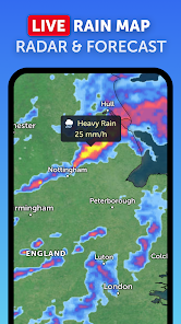
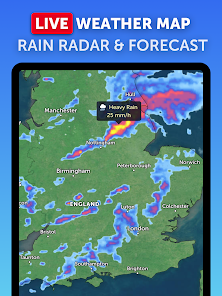
RAIN RADAR & NOWCAST
Stay ahead of the storm with our weather radar map, which shows rain and snow detected by ground-based Doppler radar in real-time, and provides an instant short-term weather forecast with radar nowcasting.
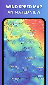
WEATHER FORECAST MAPS
Explore beautiful, interactive visualisations of the weather with our stunning global forecast maps. Our maps are continually updated with the latest weather forecast model data from DWD ICON and NOAA/NCEP/NWS GFS. Weather forecast maps include:
Precipitation Forecast - Rain, snow, and cloud cover, all in one map.
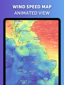
Wind Speed Forecast - Average speed and direction of surface winds.
Wind Gusts Forecast - Maximum speed of sudden bursts of wind.
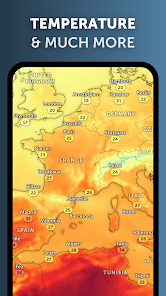
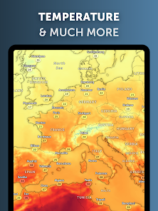
Temperature Forecast - Air temperatures at 2 meters (6 feet) above the ground.
"Feels Like" Temperature Forecast - Perceived temperatures, also known as apparent temperature or heat index.
Relative Humidity Forecast - How air moisture compares to temperature.
Dew Point Forecast - How dry or humid the air feels, and the point at which condensation occurs.
Atmospheric Pressure Forecast - The average atmospheric pressure at sea level. Low-pressure areas often bring cloudy and windy weather. High-pressure areas are associated with clear skies and lighter winds.
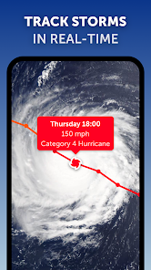
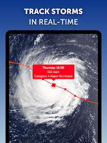
HURRICANE TRACKING
Follow hurricanes from development to category 5 in real-time with our best-in-class tropical tracking system. Information is clear and easy to understand. Our hurricane tracking weather maps are updated using the very latest data from NHC, JTWC, NRL, and IBTrACS.
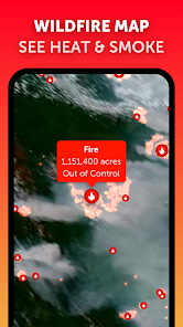
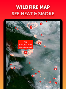
WILDFIRE TRACKING
Monitor wildfires with our active fires and heat spots overlay, which shows points of very high temperature detected by satellite. Detections are updated daily with data from NASA FIRMS. Use in conjunction with our GeoColor satellite imagery to see the movement of wildfire smoke and monitor fire weather in near real-time.
CUSTOMISATION
Adjust temperature units, wind units, time zone, animation styles, and many more features with our comprehensive settings.
LEGAL
Terms of Service: https://zoom.earth/legal/terms/
Privacy Policy: https://zoom.earth/legal/privacy/
Zoom Earth is an interactive weather map of the world and a real-time tracker of storms and hurricanes.
Explore the current weather and see forecasts for your location through interactive weather maps of rain, wind, temperature, pressure, and more.
With Zoom Earth, you can track the development of storms, hurricanes, and severe weather, monitor wildfires and smoke, and stay aware of the latest conditions by viewing satellite imagery and rain radar updated in near real‑time.
SATELLITE IMAGERY
Zoom Earth shows weather maps with near real-time satellite imagery. Images are updated every 10 minutes, with a delay between 20 and 40 minutes.
Live satellite images are updated every 10 minutes from NOAA GOES and JMA Himawari geostationary satellites. EUMETSAT Meteosat images are updated every 15 minutes.
HD satellite images are updated twice a day from NASA polar-orbiting satellites Aqua and Terra.
RAIN RADAR & NOWCAST
Stay ahead of the storm with our weather radar map, which shows rain and snow detected by ground-based Doppler radar in real-time, and provides an instant short-term weather forecast with radar nowcasting.
WEATHER FORECAST MAPS
Explore beautiful, interactive visualisations of the weather with our stunning global forecast maps. Our maps are continually updated with the latest weather forecast model data from DWD ICON and NOAA/NCEP/NWS GFS. Weather forecast maps include:
Precipitation Forecast - Rain, snow, and cloud cover, all in one map.
Wind Speed Forecast - Average speed and direction of surface winds.
Wind Gusts Forecast - Maximum speed of sudden bursts of wind.
Temperature Forecast - Air temperatures at 2 meters (6 feet) above the ground.
"Feels Like" Temperature Forecast - Perceived temperatures, also known as apparent temperature or heat index.
Relative Humidity Forecast - How air moisture compares to temperature.
Dew Point Forecast - How dry or humid the air feels, and the point at which condensation occurs.
Atmospheric Pressure Forecast - The average atmospheric pressure at sea level. Low-pressure areas often bring cloudy and windy weather. High-pressure areas are associated with clear skies and lighter winds.
HURRICANE TRACKING
Follow hurricanes from development to category 5 in real-time with our best-in-class tropical tracking system. Information is clear and easy to understand. Our hurricane tracking weather maps are updated using the very latest data from NHC, JTWC, NRL, and IBTrACS.
WILDFIRE TRACKING
Monitor wildfires with our active fires and heat spots overlay, which shows points of very high temperature detected by satellite. Detections are updated daily with data from NASA FIRMS. Use in conjunction with our GeoColor satellite imagery to see the movement of wildfire smoke and monitor fire weather in near real-time.
CUSTOMISATION
Adjust temperature units, wind units, time zone, animation styles, and many more features with our comprehensive settings.
LEGAL
Terms of Service: https://zoom.earth/legal/terms/
Privacy Policy: https://zoom.earth/legal/privacy/
Updated on
Safety starts with understanding how developers collect and share your data. Data privacy and security practices may vary based on your use, region and age The developer provided this information and may update it over time.


Ratings and reviews
4.8
74.4K reviews

Ray Knight
- Flag inappropriate
28 June 2023
Excllent source of visual weather info. Tapping on any position gives data specific to that location. The mileage and area size features are handy and easy to use. Tracking major storms and seeing projected paths and forecast strength is a big help to those of us in high-threat areas. Lots of valuable info available in readily accesible form. Great app!
204 people found this review helpful

Terrence S
- Flag inappropriate
- Show review history
26 July 2024
One of the best weather apps, I like that there are more than one models to compare to help determine possibility or rain/storms. This played an important role for me especially tracking Hurricane Beryl's path. I would like to see more weather models incorporated for a better comparison to help a bit more with predictable accuracy. You can also look at a dust/dry air forecast as well.
5 people found this review helpful

Anthony Tran
- Flag inappropriate
- Show review history
20 July 2024
The best weather app I've used so far! The visualization of the weather on the map is beautiful and very useful. Update: After using the app for 2 months I unfortunately think the data is not reliable enough. I find myself checking other sources more due to multiple occasions when I got wet from the rain thinking it would stay dry according to the data from this app
9 people found this review helpful
What's new
- New! Radar Nowcast. The radar map now shows an instant rain forecast based on real-time data. Coverage is limited.
- Improved Tropical Tracking. Disturbances that are being monitored by the National Hurricane Center are now displayed on the map.
- Other Minor Fixes and Improvements.
- Improved Tropical Tracking. Disturbances that are being monitored by the National Hurricane Center are now displayed on the map.
- Other Minor Fixes and Improvements.


