
onX Hunt: GPS Hunting Maps
In-app purchases
4.6star
53.9K reviews
50L+
Downloads

Everyone
info


About this app
onX Hunt is a fully-functioning GPS navigation App on your phone. View private and public property land ownership data, landowner names, and property lines on your custom maps. Easily view hunting units, roads and trails, U.S. topographic maps, and more.
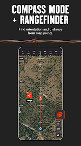
New features, including Aerial imagery, Compass Mode with Rangefinder, and Trail Camera Integration ensure onX is your go-to tool for this hunting season and beyond. Our new Two-State Premium Membership allows you to have full access to all onX features in two states, ideal for hunters who cross state lines.
Plus, new phone-free functionality for Wear OS lets you instantly drop a waypoint from your wrist with one click, seamlessly syncing to the Hunt App on your phone. Stay focused on the hunt without needing to look at your phone, enhancing your efficiency and safety in the field.
▶Government Information
onXmaps, Inc. does not represent any government or political entity, though you may find various links to public information within our services. For more info on any government information found within the services, click on the associated .gov link.
▶ FREE TRIAL:
While the onX Hunt App and many of its features are free, you’ll start a free Premium State Membership trial when you install the App. This allows you to try a full-featured Premium State Membership for seven days.
▶ FREE HUNTING APP FEATURES:
• NO ADS
• Satellite Maps with GPS Navigation
• Pan and zoom to see terrain
▶ OFFLINE GPS FUNCTIONALITY:
Turn your phone into an outdoor handheld GPS navigator using the built-in GPS to display your location on the map. Cellular coverage is NOT needed as tile-saving technology allows you to save basemaps and layers for offline navigation.
▶ DESKTOP MAPS: Memberships also include access to our online Web Hunting Map (www.onxmaps.com/web).
• Scout from the comfort of your home
• Sync markups and tracks between devices
• Print unlimited free maps
▶ PREMIUM SINGLE-STATE MEMBERSHIP:
This membership costs $34.99/year. Get all the great features of the free onX Hunt App PLUS the additional benefits of:
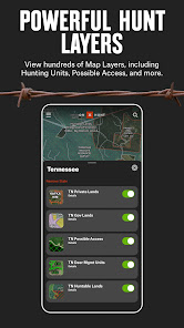
• Public land like Forest Service, Bureau of Land Management (BLM maps), Wildlife Management Areas, county and state land hunting maps, Timber Lands, and more
• 3D maps on phone and desktop
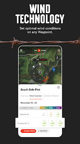
• Optimal Wind and Wind Calendar for stand locations and hunt planning
• Landowner names with property line maps and land boundaries finder in available counties (U.S. only)
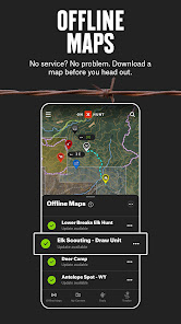
• Save private or public hunting land maps for offline use
• GMU or Hunting Units for multiple species
• Possible Access Lands, Walk-In Areas, Block Management Areas, and private lands open to the public
* Private land ownership maps may not be available for all counties (U.S. only)
▶ PREMIUM TWO-STATE MEMBERSHIP:
With a Premium Two-State Membership, you get all the benefits of our Premium Single-State Membership, but for two states. A Premium Two-State Membership costs $49.99/year and gets you all the great features of the free onX Hunt App PLUS the additional benefits listed above.
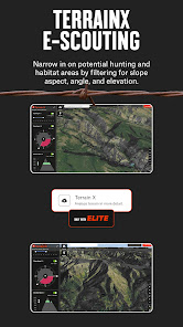
▶ ELITE NATIONWIDE MEMBERSHIP:
The best tool for the best hunters. With an Elite Membership, you get a complete, purpose-built solution for dedicated hunters and the game they pursue, including:
• Proprietary maps for all 50 states
• Advanced Tools: TerrainX 3D, Recent Imagery, Route Builder
• Elite-exclusive pro deals and expert resources
• Available for $99.99/year or $14.99/month.
▶onX HUNT GOVERNMENT DATA SOURCES:
https://data.fs.usda.gov/geodata/
https://gbp-blm-egis.hub.arcgis.com/
https://www.arcgis.com/home/group.html?id=00f2977287f74c79aad558708e3b6649#overview
▶ TERMS OF USE:
https://www.onxmaps.com/tou
▶ FEEDBACK:
Have a problem or want to request new features? Please contact us at support@onxmaps.com
New features, including Aerial imagery, Compass Mode with Rangefinder, and Trail Camera Integration ensure onX is your go-to tool for this hunting season and beyond. Our new Two-State Premium Membership allows you to have full access to all onX features in two states, ideal for hunters who cross state lines.
Plus, new phone-free functionality for Wear OS lets you instantly drop a waypoint from your wrist with one click, seamlessly syncing to the Hunt App on your phone. Stay focused on the hunt without needing to look at your phone, enhancing your efficiency and safety in the field.
▶Government Information
onXmaps, Inc. does not represent any government or political entity, though you may find various links to public information within our services. For more info on any government information found within the services, click on the associated .gov link.
▶ FREE TRIAL:
While the onX Hunt App and many of its features are free, you’ll start a free Premium State Membership trial when you install the App. This allows you to try a full-featured Premium State Membership for seven days.
▶ FREE HUNTING APP FEATURES:
• NO ADS
• Satellite Maps with GPS Navigation
• Pan and zoom to see terrain
▶ OFFLINE GPS FUNCTIONALITY:
Turn your phone into an outdoor handheld GPS navigator using the built-in GPS to display your location on the map. Cellular coverage is NOT needed as tile-saving technology allows you to save basemaps and layers for offline navigation.
▶ DESKTOP MAPS: Memberships also include access to our online Web Hunting Map (www.onxmaps.com/web).
• Scout from the comfort of your home
• Sync markups and tracks between devices
• Print unlimited free maps
▶ PREMIUM SINGLE-STATE MEMBERSHIP:
This membership costs $34.99/year. Get all the great features of the free onX Hunt App PLUS the additional benefits of:
• Public land like Forest Service, Bureau of Land Management (BLM maps), Wildlife Management Areas, county and state land hunting maps, Timber Lands, and more
• 3D maps on phone and desktop
• Optimal Wind and Wind Calendar for stand locations and hunt planning
• Landowner names with property line maps and land boundaries finder in available counties (U.S. only)
• Save private or public hunting land maps for offline use
• GMU or Hunting Units for multiple species
• Possible Access Lands, Walk-In Areas, Block Management Areas, and private lands open to the public
* Private land ownership maps may not be available for all counties (U.S. only)
▶ PREMIUM TWO-STATE MEMBERSHIP:
With a Premium Two-State Membership, you get all the benefits of our Premium Single-State Membership, but for two states. A Premium Two-State Membership costs $49.99/year and gets you all the great features of the free onX Hunt App PLUS the additional benefits listed above.
▶ ELITE NATIONWIDE MEMBERSHIP:
The best tool for the best hunters. With an Elite Membership, you get a complete, purpose-built solution for dedicated hunters and the game they pursue, including:
• Proprietary maps for all 50 states
• Advanced Tools: TerrainX 3D, Recent Imagery, Route Builder
• Elite-exclusive pro deals and expert resources
• Available for $99.99/year or $14.99/month.
▶onX HUNT GOVERNMENT DATA SOURCES:
https://data.fs.usda.gov/geodata/
https://gbp-blm-egis.hub.arcgis.com/
https://www.arcgis.com/home/group.html?id=00f2977287f74c79aad558708e3b6649#overview
▶ TERMS OF USE:
https://www.onxmaps.com/tou
▶ FEEDBACK:
Have a problem or want to request new features? Please contact us at support@onxmaps.com
Updated on
Events and offers


Safety starts with understanding how developers collect and share your data. Data privacy and security practices may vary based on your use, region and age The developer provided this information and may update it over time.


Ratings and reviews
4.6
52.5K reviews

Salmon Slayer
- Flag inappropriate
- Show review history
28 September 2024
I hate that while I have auto update turned on IT NEVER AUTO UPDATES. It's screwed my hunt a couple times because the app didn't want to act right not updated going into an area with no service, by myself, in an area completely unfamiliar to me, in the dark. Also it's wack Af that my screen needs to be on while tracking to make a track. Great, where tf am I ? Oh lost is the word. Step your game up. You've been around way too long to be having these issues and now wanting to charge more 🤣
4 people found this review helpful
onXmaps
30 September 2024
Hi there, thanks for reaching out to us here. We're sorry for the trouble you have had on the app. It sounds like you have a few things going on here that should be fixable. Please reach out to our customer support team to walk through some trouble shooting steps. (406) 540-1600 M-F 9AM-4PM MST or help@onxmaps.com

Vahagn melikyan
- Flag inappropriate
- Show review history
6 September 2024
The app used to be good, but seems like the more time goes on the worst the quality. It's hard to move the map without crashes freezes. The private land lines are way off in many locations, or completely missing. I checked with a free website land map and it made perfect sense, meanwhile xmap is way off. So if you relying on Xmap private land lines you'll be wasting your time. I might have to cancel my subscription, because it provides a false information.
63 people found this review helpful
onXmaps
6 September 2024
Hey Vahagn,
Thank you for reaching out. We're sorry to learn about your experience. Please give our team a call, and we'd be glad to help. Our phone number is (406) 540-1600 and we're open Mon – Fri, 9am – 4pm Mountain Time.

Allen Armstrong
- Flag inappropriate
7 August 2024
Your app is awesome. Definitely the most up to date landowner information. I recommend it to everyone looking for a mapping app. It would be super amazing though if you could add in bedrock geology information. It would help a lot in identifying the terrain of trails not just the steepness of them but what you will actually be walking/driving on.
244 people found this review helpful
onXmaps
8 August 2024
Thank you for your kind words and for recommending onX Hunt! We’re pleased to hear that you find our landowner data useful. Your idea for adding bedrock geology information is intriguing, and we’ll look into how we might integrate this in future updates.
App support
phone
Phone number
+14065401600
About the developer
onXmaps, Inc.
onx.it@Onxmaps.com
1925 Brooks St
Missoula, MT 59801
United States
+1 401-206-0689


