
Colorado Roads
Contains ads
1.3star
1.41K reviews
100K+
Downloads

Everyone
info


About this app
Colorado Roads has the most accurate data about what’s happening on Colorado’s highways in real-time.
Quite simply, we want to help you get to where you need to go quickly and safely as you travel throughout the beautiful state of Colorado.
Our App is refreshed / updated frequently with the most up-to-date travel information available so be sure to check in regularly.
What You Get
Colorado Roads will provide travelers with:
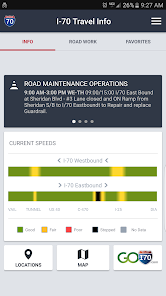
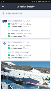
•speeds and travel times
•road conditions
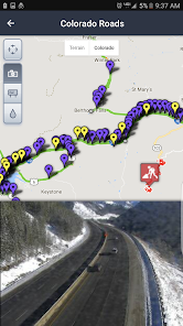
•incidents and road closures
•road work to include construction and maintenance activities
•and data from Colorado Roads's closed circuit television cameras
All available in real-time -- and based upon your location.
The information Colorado Roads provides on Colorado Roads is enhanced with data from:
•weather data from Weather Underground
•directional maps from Google
•as well as offers and deals from businesses near you
All in an effort to provide you with the most complete travel data.
Your Privacy is Important to Us
Colorado Roads Mobile will NOT:
•make available any of your personal information
•sell any of your personal data
•transmit your location outside of your device
Your data is analyzed only in aggregate and used only for the purposes of improving and enhancing the features and performance of the application.
Quite simply, we want to help you get to where you need to go quickly and safely as you travel throughout the beautiful state of Colorado.
Our App is refreshed / updated frequently with the most up-to-date travel information available so be sure to check in regularly.
What You Get
Colorado Roads will provide travelers with:
•speeds and travel times
•road conditions
•incidents and road closures
•road work to include construction and maintenance activities
•and data from Colorado Roads's closed circuit television cameras
All available in real-time -- and based upon your location.
The information Colorado Roads provides on Colorado Roads is enhanced with data from:
•weather data from Weather Underground
•directional maps from Google
•as well as offers and deals from businesses near you
All in an effort to provide you with the most complete travel data.
Your Privacy is Important to Us
Colorado Roads Mobile will NOT:
•make available any of your personal information
•sell any of your personal data
•transmit your location outside of your device
Your data is analyzed only in aggregate and used only for the purposes of improving and enhancing the features and performance of the application.
Updated on
Data safety
Developers can show information here about how their app collects and uses your data. Learn more about data safety

No information available
Ratings and reviews
1.3
1.33K reviews

A Google user
- Flag inappropriate
4 March 2019
I used to love this app, but it does not load google maps well, and there are two many key strokes needed to see what you want to see. Also, the main state map cannot be populated with many options at once. Cameras, closures, chain restrictions, DOT incidents or accidents cannot be layered on the State map at the same time. This app needs an upgrade.
4 people found this review helpful
A Google user
- Flag inappropriate
7 March 2019
Maybe it was back in 2017 or so they redesigned this app. Before then it worked great and presented useful info on road closures in an easy-to-access format. Now it is useless. The alerts are missing location and direction information in the new release. You can click through to a tiny pointer on the map that doesn't give the direction or start/end mile markers. Not at all helpful. Please put the road, location name (e.g. "Vail"), direction, and start/end mile markers back in the alert text.
3 people found this review helpful
A Google user
- Flag inappropriate
16 December 2019
App hasn't been updated in more than 2 years. The detailed road info is mostly just Denver metro & about 1/2 of I-70. I-25 is pretty much ignored. The road-condition & construction info does seem to update on the map, but the map says it "can't Google read maps correctly" & "for demonstration purposes only." Without the road-condition info on the map, the app would be completely useless, & it's pretty bad as it is.
26 people found this review helpful
What's new
Performance fixes


