The PHIVOLCS FaultFinder
2.9star
816 reviews
Government
info
100K+
Downloads

Everyone
info
About this app
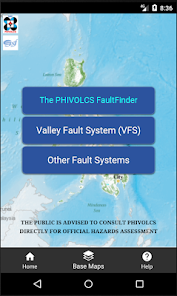
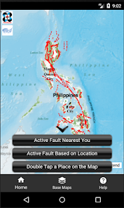
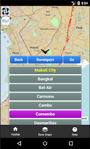
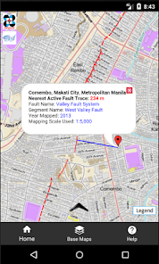
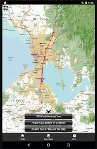
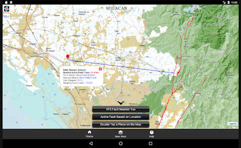
The PHIVOLCS FaultFinder mobile app shows information about the distance between the user's current location, address or selected location on the map and the nearest active fault. This app needs internet connection to access the web-based active fault database of PHIVOLCS and the necessary web services. The database provides the backend source of information for the Web Map Service (WMS) and Web Processing Service (WPS) used for displaying the active fault map and querying fault trace locations, respectively. This app uses three base maps, the Philippine Geoportal Map, Google Maps and the OpenStreetMap, which are served as web services provided by the data owners. The Philippine Geoportal Map is provided by the National Mapping and Resource Information Authority (NAMRIA) of the Philippines. This app is a classic Web-based Geographic Information System (WebGIS) following the Spatial Data Infrastructure model. The FaultFinder app is the product of the joint collaboration between the Philippine Institute of Volcanology and Seismology (PHIVOLCS), Department of Science and Technolog (DOST), Philippines and Geological Survey of Japan (GSJ), National Institute of Advanced Industrial Science and Technology (AIST), Japan. Dr. Renato Solidum, director of PHIVOLCS, initiated the idea of developing the app. The FaultFinder app was developed by Dr. Joel C. Bandibas of GSJ with the cooperation of the research and development personnel of PHIVOLCS.
Updated on
Safety starts with understanding how developers collect and share your data. Data privacy and security practices may vary based on your use, region, and age. The developer provided this information and may update it over time.

No data shared with third parties
Learn more about how developers declare sharing

No data collected
Learn more about how developers declare collection

Data isn’t encrypted
Ratings and reviews
2.8
786 reviews

Fran de la Rosa
- Flag inappropriate
October 6, 2025
Great app for awareness. Unfortunately, the "legend" icon doesn't work. There's no way for us to know what other icons mean except for the red line, which is obviously the fault line.
3 people found this review helpful

Rhaine Lopez
- Flag inappropriate
October 10, 2025
I read some reviews that it's slow. I think they have updated the app now, and I was able to get my results quickly. Thank you, this is informative and helpful.
11 people found this review helpful

SushiRollGuy
- Flag inappropriate
October 12, 2025
What is wrong with you guys? I've been using this app ever since the web version stopped working, and then this app also stopped working on my Huawei P20. I eventually found out that it's no longer compatible with my phone. So now, the app just decided to be very picky with devices? I just wanted an informative app to address my concerns about earthquakes and fault lines. Stop risking other people's lives by making your app useless. I might as well switch to other apps at this point.
7 people found this review helpful
Joel Bandibas
October 12, 2025
It is Google Play Store's decision to be "picky", not the app. Older versions of Android OS has some security issues. So if you want to use the app, upgrade your OS to Android 14 or higher. If it is not possible, send me email (joelbandibas@gmail.com) for a possible workaround.
App support
About the developer
Joel Calupas Bandibas
joelbandibas@gmail.com
Japan
undefined


