
Innerste-Radweg
1K+
Downloads

Everyone
info


About this app
The Innerste cycle path - also known as the World Heritage cycle path - is 105 kilometers long and runs between Clausthal-Zellerfeld and Sarstedt.
Experience nature and culture, this app makes both possible!
Because in this tour, not only the route from the Innerste-Sprung from the Upper Harz to the Leinetal is integrated; The first world cultural heritage on this tour was also taken into account by choosing the starting point in Goslar.
In order to have enough time to enjoy the impressive landscape, nature and cultural experiences, this tour is divided into three stages. The individual stages can of course also be adapted individually.
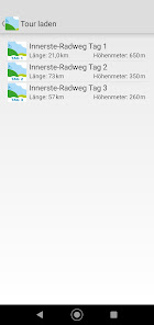
Day 1: Goslar - Clausthal-Zellerfeld / 21 km / 650 vertical meters
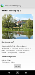
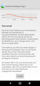
Day 2: Clausthal-Zellerfeld - Grasdorf / 73 km / 350 meters in altitude
Day 3: Grasdorf - Sarstedt / 57 km / 260 vertical meters
The tour descriptions in the app are supplemented by information as well as contact addresses, opening times, etc. on sights, places to stop and overnight (POIs).
A detailed tour description and the GPS track for download can be found here:
https://www.gps-tour.info/de/touren/detail.172232.html
Function description:
After installing the app, the map data is loaded. If your smartphone is connected to a WLAN, this happens automatically. The data can also be downloaded using a cellular connection. To do this, tap the pop-up window to confirm. Please note that this is done at the expense of your data volume.
You can now use the app "offline". This means that an internet connection is no longer required. An online connection must be established to access external Internet sites, e-mail and telephone calls. If WLAN is not available, activate the "Mobile data" switch in the settings of your smartphone.
So that your current position is displayed on the map, please confirm that the app always has access to your device location.
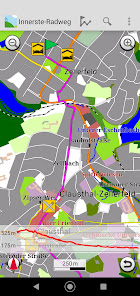
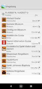
A detailed description of the tours with a lot of information such as length, altitude, level of difficulty and the route with information on POIs (places of interest) can be called up. There are tips and recommendations for each POI. If a suitable tour is found, it can be called up and the starting point appears immediately on the map. Your current position is constantly displayed and tracked.
How far it is to the destination is shown by the remaining kilometer display at the top of the screen. If you leave the route by turning the wrong way, for example, you will hear a warning tone. Arriving at your destination safe and relaxed is no problem.
Press and hold on a POI symbol on the map to call up detailed information. These usually consist of a picture, detailed description, tips and information, as well as address, telephone number and link to the website, if available. A call can be made with one click or the website can be called up directly, which then provides current and further information.
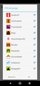
In order to keep the map clear, content can be thinned out and the display of the POIs can be individually adjusted in the settings. Depending on the focus or application, you can determine what is displayed.
You can find more information on operation in the "Help" menu.
Experience nature and culture, this app makes both possible!
Because in this tour, not only the route from the Innerste-Sprung from the Upper Harz to the Leinetal is integrated; The first world cultural heritage on this tour was also taken into account by choosing the starting point in Goslar.
In order to have enough time to enjoy the impressive landscape, nature and cultural experiences, this tour is divided into three stages. The individual stages can of course also be adapted individually.
Day 1: Goslar - Clausthal-Zellerfeld / 21 km / 650 vertical meters
Day 2: Clausthal-Zellerfeld - Grasdorf / 73 km / 350 meters in altitude
Day 3: Grasdorf - Sarstedt / 57 km / 260 vertical meters
The tour descriptions in the app are supplemented by information as well as contact addresses, opening times, etc. on sights, places to stop and overnight (POIs).
A detailed tour description and the GPS track for download can be found here:
https://www.gps-tour.info/de/touren/detail.172232.html
Function description:
After installing the app, the map data is loaded. If your smartphone is connected to a WLAN, this happens automatically. The data can also be downloaded using a cellular connection. To do this, tap the pop-up window to confirm. Please note that this is done at the expense of your data volume.
You can now use the app "offline". This means that an internet connection is no longer required. An online connection must be established to access external Internet sites, e-mail and telephone calls. If WLAN is not available, activate the "Mobile data" switch in the settings of your smartphone.
So that your current position is displayed on the map, please confirm that the app always has access to your device location.
A detailed description of the tours with a lot of information such as length, altitude, level of difficulty and the route with information on POIs (places of interest) can be called up. There are tips and recommendations for each POI. If a suitable tour is found, it can be called up and the starting point appears immediately on the map. Your current position is constantly displayed and tracked.
How far it is to the destination is shown by the remaining kilometer display at the top of the screen. If you leave the route by turning the wrong way, for example, you will hear a warning tone. Arriving at your destination safe and relaxed is no problem.
Press and hold on a POI symbol on the map to call up detailed information. These usually consist of a picture, detailed description, tips and information, as well as address, telephone number and link to the website, if available. A call can be made with one click or the website can be called up directly, which then provides current and further information.
In order to keep the map clear, content can be thinned out and the display of the POIs can be individually adjusted in the settings. Depending on the focus or application, you can determine what is displayed.
You can find more information on operation in the "Help" menu.
Updated on
Safety starts with understanding how developers collect and share your data. Data privacy and security practices may vary based on your use, region, and age. The developer provided this information and may update it over time.

No data shared with third parties
Learn more about how developers declare sharing

No data collected
Learn more about how developers declare collection

Data isn’t encrypted
App support
About the developer
FootMap GmbH
info@footmap.de
Dingworthstr. 25-27
31137 Hildesheim
Germany
+49 1525 5187090


