
PointMan: GIS Data Collector

4.1star
204 reviews
50K+
Downloads

Everyone
info


About this app
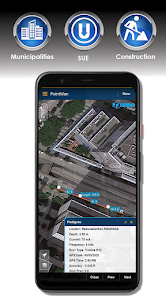
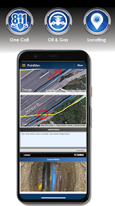
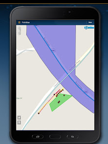
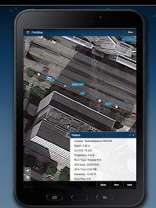
PointMan is a unique Precision Mapping Solution. Use PointMan Plus to help capture, record, and visualize the precise (x, y, z) location of critical surface & subsurface utility assets. PointMan's mobile app allows users to connect their mobile device with major GPS/GNSS, cable, and pipe locating equipment manufacturers to capture mission critical infrastructure data with unprecedented precision that includes; type, depth, accuracy, depth of cover, and precise geospatial location. PointMan can also create and bind forms, sketches, and photos to any point, line, or polygon and works in unison with mobile devices in order to display captured meta-data into a reliable mobile mapping software, all from the palm of your hand.
Upgrade to PointMan Pro to visualize, sync, and communicate meta-data captured by field personnel and make it immediately available for other office or field team members to view, in REAL-TIME. PointMan enhances captured-data security by working in unison between field equipment and mobile device, backing up critical asset data as it's being collected, and integrates it into an easy to use Precision Mapping Solution, viewable from any mobile device or desktop logged into PointMan Cloud Server, backed by AWS.
PointMan comes with a free 15 day trial of PointMan Plus features. After the trial period a one year subscription must be purchased to continue using the Plus features.
Plus features include:
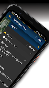
Data Dictionary
Precision and Pedigree attributes
Differential correction
Export to Shapefile, CSV, and PDF
Import from Shapefile and KMZ
Locate PDF form
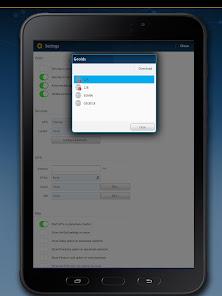
Geoid correction
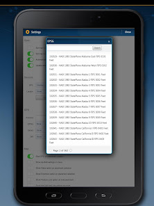
Datum/EPSG collection
Multi-Feature Collect
***********************************************************
Uninstalling PointMan:
If you are a Plus user uninstalling will remove project data stored on your device. It is important to backup any project data before uninstalling PointMan.
Contact support@pointman.com
Upgrade to PointMan Pro to visualize, sync, and communicate meta-data captured by field personnel and make it immediately available for other office or field team members to view, in REAL-TIME. PointMan enhances captured-data security by working in unison between field equipment and mobile device, backing up critical asset data as it's being collected, and integrates it into an easy to use Precision Mapping Solution, viewable from any mobile device or desktop logged into PointMan Cloud Server, backed by AWS.
PointMan comes with a free 15 day trial of PointMan Plus features. After the trial period a one year subscription must be purchased to continue using the Plus features.
Plus features include:
Data Dictionary
Precision and Pedigree attributes
Differential correction
Export to Shapefile, CSV, and PDF
Import from Shapefile and KMZ
Locate PDF form
Geoid correction
Datum/EPSG collection
Multi-Feature Collect
***********************************************************
Uninstalling PointMan:
If you are a Plus user uninstalling will remove project data stored on your device. It is important to backup any project data before uninstalling PointMan.
Contact support@pointman.com
Updated on
Safety starts with understanding how developers collect and share your data. Data privacy and security practices may vary based on your use, region and age The developer provided this information and may update it over time.

No data shared with third parties
Learn more about how developers declare sharing

This app may collect these data types
Location, Personal info and 4 others

Data is encrypted in transit

You can request that data be deleted
Ratings and reviews
4.1
193 reviews

Bradley
- Flag inappropriate
- Show review history
08 November 2022
No one does GPS as well for some gear though there are some up and coming developers. I really thought this would be the new standard; however, they have an edge due to industry apathy. The app isn't as great as it appeared at first glance. The data isn't granular or easily manipulated. It's perfect for point collecting with equipment with some unfinished bells and whistles. They will dominate like most for being first on the scene but their sales team didn't impress. They were in their own way.
38 people found this review helpful

Ivan Imes
- Flag inappropriate
22 July 2022
Upon installing the app, it informed me that it was only a 14 day trial. Not interested in using the app if I will become unable to do so in 2 weeks time. The description in the store was unclear about this, would have appreciated a more explicit declaration that the app was just a trial.
64 people found this review helpful

Kenneth Smith
- Flag inappropriate
14 September 2020
JUST RECEIVED THE RS2 SATURDAY. (9-12-2020) SUPER FAST FIXES. WELL WORTH THE MONEY. I AM USING POINTMAN SOFTWARE WITH THE RS2 (WHICH REQUIRES THE REACH APP TO SET UP AND OPERATE) TO DESIGN UTILITY LAYOUTS, COLLECT UTILITY LOCATION DATA AND TO STAKE OUT UTILITIES AFTER THEY HAVE BEEN COLLECTED. THE NEW RS2 WILL MAKE THIS PROCESS A LOT FASTER AND MORE EFFICIENT. I WAS USING THE RS+ BUT THIS IS GOING TO BE A LOT BETTER NOT HAVING TO WAIT AS LONG FOR A FIX THAT WILL ALLOW SUB CENTIMETER GPS DATA COLLECTION.THE REALLY COOL THING IS IF YOU LOOSE YOUR FIX IT LITERALLY ONLY TAKES SECONDS TO REAQUIRE.
6 people found this review helpful
What's new
-Plus users can now backup and store projects on the cloud.
App support
phone
Phone number
+19706835530
About the developer
Prostar Geocorp., Inc.
support@prostarcorp.com
760 Horizon Dr Ste 200
Grand Junction, CO 81506
United States
+1 970-242-4024


