
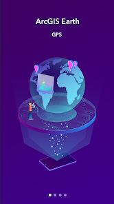
ArcGIS Earth
4,0star
1,08K avis
100K+
Téléchargements

Tout public
info


À propos de l'application
ArcGIS Earth is a native application available on iOS, Android, and Windows platforms. It enables users to access content, tools, and analysis from anywhere, whether it's online or offline. ArcGIS Earth is designed for everyone and provides user-friendly 3D experiences. It's also consistent between the desktop and mobile environments and adaptable to many collaborative scenarios.
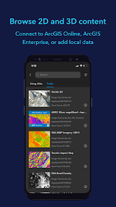
Data support
ArcGIS Earth allows you to use a variety of items from ArcGIS Online, ArcGIS Enterprise, local data, and web services:
• Browse web scenes, map services, image services, scene services, and feature services.
• Browse local files including mobile scene packages (MSPK), KML, KMZ, tile packages, and scene layer packages (SLPK).
• Support has been added for Living Atlas of the World.
Key features
• Connect to ArcGIS Online or ArcGIS Enterprise.
• Tap to identify features.
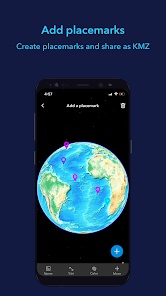
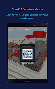
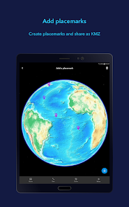
• Support has been added for collecting, editing, and sharing placemarks.
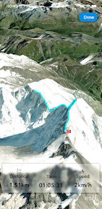
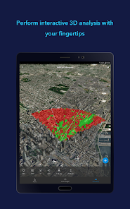
• Interactive analysis tools include Measure, Line of Sight, and Viewshed.
• Create and share tours with geotagged photos.
• Search for places and switch locators.
• Start-up tips and guidance for hand gestures are included.
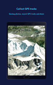
• Record and preview GPS tracks, and share with your organization.
Data support
ArcGIS Earth allows you to use a variety of items from ArcGIS Online, ArcGIS Enterprise, local data, and web services:
• Browse web scenes, map services, image services, scene services, and feature services.
• Browse local files including mobile scene packages (MSPK), KML, KMZ, tile packages, and scene layer packages (SLPK).
• Support has been added for Living Atlas of the World.
Key features
• Connect to ArcGIS Online or ArcGIS Enterprise.
• Tap to identify features.
• Support has been added for collecting, editing, and sharing placemarks.
• Interactive analysis tools include Measure, Line of Sight, and Viewshed.
• Create and share tours with geotagged photos.
• Search for places and switch locators.
• Start-up tips and guidance for hand gestures are included.
• Record and preview GPS tracks, and share with your organization.
Date de mise à jour
La sécurité, c'est d'abord comprendre comment les développeurs collectent et partagent vos données. Les pratiques concernant leur confidentialité et leur protection peuvent varier selon votre utilisation, votre région et votre âge. Le développeur a fourni ces informations et peut les modifier ultérieurement.

Aucune donnée partagée avec des tiers
En savoir plus sur la manière dont les développeurs déclarent le partage

Aucune donnée collectée
En savoir plus sur la manière dont les développeurs déclarent la collecte
Notes et avis
4,0
1,05K avis
Nouveautés
The following enhancements have been added for version 2.1:
• Support for viewing 3D tiles data from services and local files.
• Support for adding OGC GeoPackage from local files or downloading it from portal items. • Support for launching the ArcGIS Earth app from a universal link with parameters.
• Enhanced drawing editor with picture attachments.
• View and play slides embedded in a web scene.
Assistance de l'appli
phone
Numéro de téléphone
+19097932853


