
HikeNode
ବିଜ୍ଞାପନ ଅନ୍ତର୍ଭୂକ୍ତ
10ହ+
ଡାଉନଲୋଡଗୁଡ଼ିକ

ସମସ୍ତେ
info

ଏହି ଆପ୍ ବିଷୟରେ
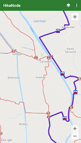
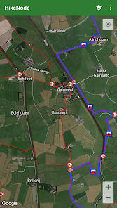
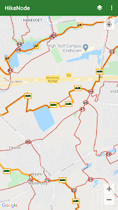
HikeNode shows hiking routes worldwide on the map. Long distance trails like the European long-distance paths (E-paths) across Europe, the Camino de Santiago (Way of St. James) in Spain and the Pieterpad in the Netherlands are shown, as well as routes between hike nodes and local trails.
HikeNode is not a navigation app; it just shows an overview of all the trails in different colors.
Europe has the best coverage of hiking trails. The coverage in other parts of the world is less. HikeNode gets the route network from WayMarkedTrails.org that in turn gets its data from OpenStreetMap.org.
ଗତ ଅପଡେଟର ସମୟ
ଡେଭେଲପରମାନେ ଆପଣଙ୍କ ଡାଟାକୁ କିପରି ସଂଗ୍ରହ ଏବଂ ସେୟାର କରନ୍ତି ସେହି ଧାରଣା ସହିତ ସୁରକ୍ଷା ଆରମ୍ଭ ହୁଏ। ଆପଣଙ୍କ ବ୍ୟବହାର, ଅଞ୍ଚଳ ଏବଂ ବୟସ ଆଧାରରେ, ଡାଟା ଗୋପନୀୟତା ଓ ସୁରକ୍ଷା କାର୍ଯ୍ୟପଦ୍ଧତିଗୁଡ଼ିକ ଭିନ୍ନ ହୋଇପାରେ। ଡେଭେଲପର ଏହି ସୂଚନା ପ୍ରଦାନ କରିଛନ୍ତି ଏବଂ ସେ ସମୟାନୁସାରେ ଏହାକୁ ଅପଡେଟ କରିପାରନ୍ତି।

ଏହି ଆପ ତୃତୀୟ ପକ୍ଷଗୁଡ଼ିକ ସହ ଏହି ଡାଟା ପ୍ରକାରଗୁଡ଼ିକ ସେୟାର କରିପାରେ
ଡିଭାଇସ କିମ୍ବା ଅନ୍ୟ IDଗୁଡ଼ିକ

କୌଣସି ଡାଟା ସଂଗ୍ରହ କରାଯାଇନାହିଁ
ଡେଭେଲପରମାନେ କିପରି ସଂଗ୍ରହର ଘୋଷଣା କରନ୍ତି ସେ ବିଷୟରେ ଅଧିକ ଜାଣନ୍ତୁ

ଟ୍ରାଞ୍ଜିଟ ସମୟରେ ଡାଟା ଏନକ୍ରିପ୍ଟ କରାଯାଇଥାଏ
ନୂଆ କଣ ଅଛି
Updated to meet latest Android requirements and a minor other update. See help/blog for details.


