

In Sight - Norway+


Everyone
info
1K+
Downloads

Everyone
Learn more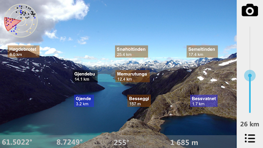


About this app
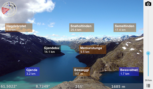
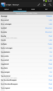
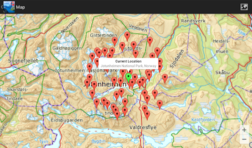
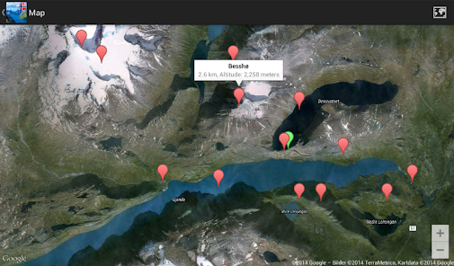
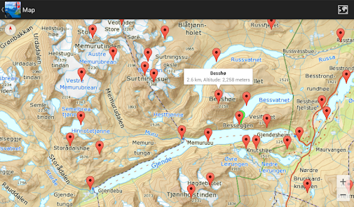
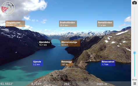
What is the name of the mountain you can see in the distance? What are the lakes you see in front of you? Point there with In Sight Norway+ and you'll see on the screen what they are called. See also places nearby with amazing high-resolution maps. High resolution offline maps of Norway are used down to a scale of 1:70 000.
Recommended by visitnorway.com 28/6 2014.
Also check out our new app "In Sight Svalbard" with completely offline high resolution maps.
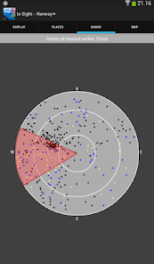
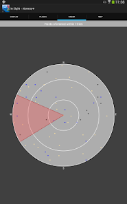
* Offline Augmented Reality in Norway *
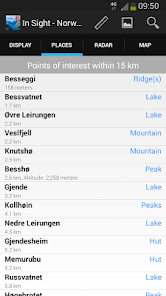
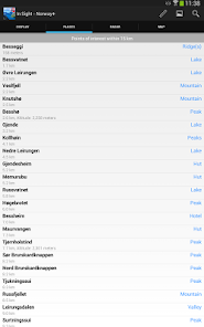
See what's near you where you travel in Norway: Mountains, Lakes, Places, Buildings, etc. You don't even have to be nearby Norway: You can manually set your location to a place in Norway to pretend you are there. Decide if you want to see places nearby, or famous cities around the world.
Works everywhere: By the sea, in the mountains, in the city. Without the internet, without coverage.
Turn the phone sideways to view on the camera screen the places that are nearby. Take a picture of what you see, and send it by email, or post it on facebook, directly from the App!
You can also add your own places!
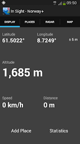
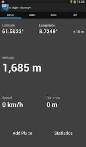
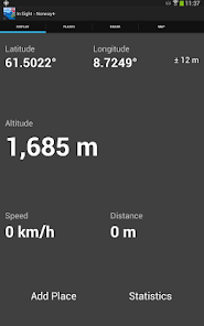
In Sight Norway+ is also an altimeter, speedometer and also estimates the distance you've traveled. Choose between metric (km, meter) or imperial (miles, feet) units.
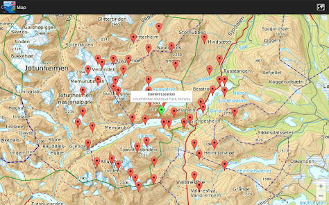
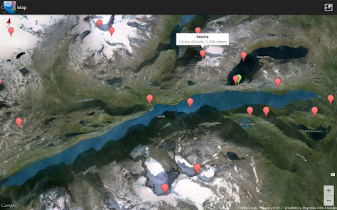
All data is built into the App, so you don't need internet. You only need internet when you use the map or send a picture on email or post it on facebook. High-resolution maps down to a scale of 1:70 000 don’t require internet. For finer resolution internet is used.
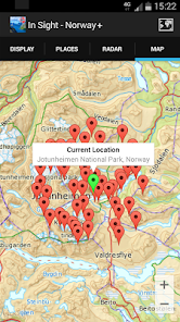
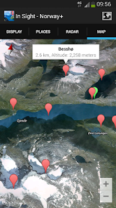
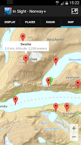
Select between the following map types: Standard, Satellite, Hybrid, High Resolution and Sea Map. High resolution maps and sea maps are provided by the Norwegian Mapping Authority.
In Sight Norway+ relies on the compass and GPS of your device. Best results are achieved if you are outside.
COMPASS CALIBRATION AND ACCURACY.
One way to calibrate the compass is to move the phone in an 8-number manner 3 times: Once when the phone is in landscape, once in portrait and once facing up. Also stay away from magnetic sources that might influence the compass. For the compass to be accurate under usage, you have to be outside to get a good location reading.
Source: ws.geonames.org under the Creative Commons Attribution 3.0 License (http://creativecommons.org/licenses/by/3.0/)
High resolution maps and sea maps from the Norwegian Mapping Authority (http://www.kartverket.no) are licensed under the Creative Commons Attribution 4.0 international (CC BY 4.0) (http://creativecommons.org/licenses/by/4.0/deed.en)
Recommended by visitnorway.com 28/6 2014.
Also check out our new app "In Sight Svalbard" with completely offline high resolution maps.
* Offline Augmented Reality in Norway *
See what's near you where you travel in Norway: Mountains, Lakes, Places, Buildings, etc. You don't even have to be nearby Norway: You can manually set your location to a place in Norway to pretend you are there. Decide if you want to see places nearby, or famous cities around the world.
Works everywhere: By the sea, in the mountains, in the city. Without the internet, without coverage.
Turn the phone sideways to view on the camera screen the places that are nearby. Take a picture of what you see, and send it by email, or post it on facebook, directly from the App!
You can also add your own places!
In Sight Norway+ is also an altimeter, speedometer and also estimates the distance you've traveled. Choose between metric (km, meter) or imperial (miles, feet) units.
All data is built into the App, so you don't need internet. You only need internet when you use the map or send a picture on email or post it on facebook. High-resolution maps down to a scale of 1:70 000 don’t require internet. For finer resolution internet is used.
Select between the following map types: Standard, Satellite, Hybrid, High Resolution and Sea Map. High resolution maps and sea maps are provided by the Norwegian Mapping Authority.
In Sight Norway+ relies on the compass and GPS of your device. Best results are achieved if you are outside.
COMPASS CALIBRATION AND ACCURACY.
One way to calibrate the compass is to move the phone in an 8-number manner 3 times: Once when the phone is in landscape, once in portrait and once facing up. Also stay away from magnetic sources that might influence the compass. For the compass to be accurate under usage, you have to be outside to get a good location reading.
Source: ws.geonames.org under the Creative Commons Attribution 3.0 License (http://creativecommons.org/licenses/by/3.0/)
High resolution maps and sea maps from the Norwegian Mapping Authority (http://www.kartverket.no) are licensed under the Creative Commons Attribution 4.0 international (CC BY 4.0) (http://creativecommons.org/licenses/by/4.0/deed.en)
Updated on
Safety starts with understanding how developers collect and share your data. Data privacy and security practices may vary based on your use, region, and age. The developer provided this information and may update it over time.

No data shared with third parties
Learn more about how developers declare sharing

No data collected
Learn more about how developers declare collection

Data isn’t encrypted
Data can’t be deleted
What’s new
Support for Android 9.
Bug fixes.
Bug fixes.
Everyone
Learn moreApp support
About the developer
Appsfab AS
appsfab@gmail.com
Oppsaltoppen 10B
0687 OSLO
Norway
+47 92 91 56 97


