BackCountry Navigator TOPO GPS
Contains adsIn-app purchases

3.6star
6.91K reviews
100K+
Downloads

Everyone
info


About this app
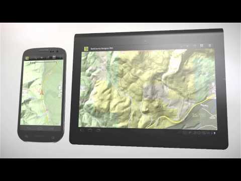
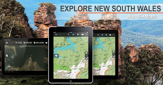
Download topo maps for an offline outdoor navigator! Use your phone or tablet as an offroad topo mapping handheld GPS with the bestselling outdoor navigation app for Android! Explore beyond cell coverage for hiking and other recreation.
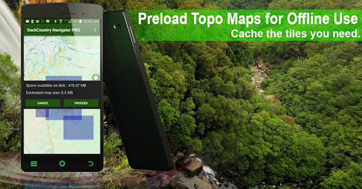
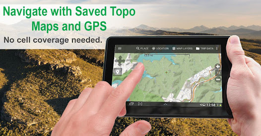
Download topo maps in advance, so you won't need cell coverage for navigation. Use storage memory for maps.
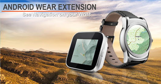
New: Android Wear support to see navigation at a glance on wrist
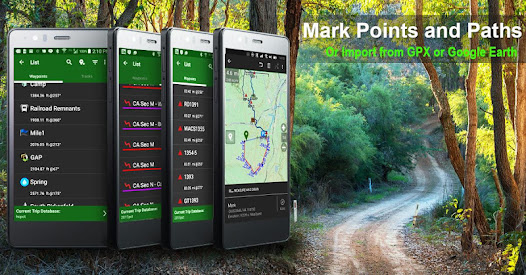
Use GPS waypoints from GPX or KML files, or enter your own coordinates using longitude/latitude, UTM, MGRS, or grid reference. Using GOTO makes a waypoint a locus for navigation.
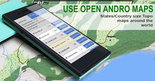
This uses many publicly available map sources as free downloads.
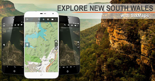
Many in Australia are using Open Cycle Maps, a worldwide map source.
You may try the DEMO version to make sure you like the maps in your country.
About topo (topographic) maps: Topo maps show terrain through color and contours, and are useful for navigation offroad. Topo maps and GPS can be used for hiking, hunting, kayaking, snowshoeing, & backpacker trails.
You can create your own maps with Mobile Atlas Creator, or specify a custom tile server. Built in sources include:
OpenStreetMaps from MapQuest
OpenCycleMaps are topo maps of most of the world.
Topo maps of New Zealand from LINZ
Aerial Photography of New Zealand from LINZ
Japan GSI maps.
Various sources of the US and Europe
OpenAndroidMaps - prepacked compact topo maps of provinces, states, or countries.
The above sources are generally free to use.
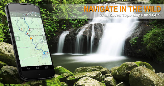
Use offline topo maps and GPS on hiking trails without cell service. The GPS in your Android phone can get its position from GPS satellites, and you don’t have to rely on your data plan to get maps. Have more fun and safe GPS navigation in the backcountry.
Use as a geocaching navigator by getting a pocket query as GPX.
Besides geocaching, use GPS for recording tracks and GPS waypoints on your trip, all the while tracking your GPS quest on topographic maps. It may replace your Garmin handheld GPS.
Here are some of the outdoor GPS activities BackCountry Navigator has been used for:
As a hiking GPS both on hiking trails and off trail.
Camping trips to find that perfect camping site or the way back to camp with GPS.
Hunting trips for hunting wild game in rugged areas.
Doing recon for a hunt or as your hunting GPS
Fishing: make it your fishing GPS.
Search and Rescue (SAR).
Trekking the Pacific Crest trail or other long term hiking.
Kayak and canoe treks on inland lakes and streams or marine, coastal waters.
Backpacker trips: using topo maps of wilderness areas and national forests for navigation on trails with the GPS in your rucksack or backpack.
Find your own ways to have fun in the outdoors. Be a maverick by venturing beyond cell service boundaries with your GPS. Become a pro at navigation with GPS for the outdoors.
BackCountry Navigator has been on WM devices and preloaded on the Trimble Nomad outdoor rugged device. This Android version is more flexible, featured, and fun. Create a memory with maps.
For a one time fee, this a great addition to the outdoor gear you bought at Cabelas, REI, or another outdoor store. Many have found the Android GPS in a phone or tablet to substitute for a Garmin GPS or Magellan GPS, such as the Garmin GPS units Montana, Etrex, or Oregon. Android can be your handheld GPS.
Download topo maps in advance, so you won't need cell coverage for navigation. Use storage memory for maps.
New: Android Wear support to see navigation at a glance on wrist
Use GPS waypoints from GPX or KML files, or enter your own coordinates using longitude/latitude, UTM, MGRS, or grid reference. Using GOTO makes a waypoint a locus for navigation.
This uses many publicly available map sources as free downloads.
Many in Australia are using Open Cycle Maps, a worldwide map source.
You may try the DEMO version to make sure you like the maps in your country.
About topo (topographic) maps: Topo maps show terrain through color and contours, and are useful for navigation offroad. Topo maps and GPS can be used for hiking, hunting, kayaking, snowshoeing, & backpacker trails.
You can create your own maps with Mobile Atlas Creator, or specify a custom tile server. Built in sources include:
OpenStreetMaps from MapQuest
OpenCycleMaps are topo maps of most of the world.
Topo maps of New Zealand from LINZ
Aerial Photography of New Zealand from LINZ
Japan GSI maps.
Various sources of the US and Europe
OpenAndroidMaps - prepacked compact topo maps of provinces, states, or countries.
The above sources are generally free to use.
Use offline topo maps and GPS on hiking trails without cell service. The GPS in your Android phone can get its position from GPS satellites, and you don’t have to rely on your data plan to get maps. Have more fun and safe GPS navigation in the backcountry.
Use as a geocaching navigator by getting a pocket query as GPX.
Besides geocaching, use GPS for recording tracks and GPS waypoints on your trip, all the while tracking your GPS quest on topographic maps. It may replace your Garmin handheld GPS.
Here are some of the outdoor GPS activities BackCountry Navigator has been used for:
As a hiking GPS both on hiking trails and off trail.
Camping trips to find that perfect camping site or the way back to camp with GPS.
Hunting trips for hunting wild game in rugged areas.
Doing recon for a hunt or as your hunting GPS
Fishing: make it your fishing GPS.
Search and Rescue (SAR).
Trekking the Pacific Crest trail or other long term hiking.
Kayak and canoe treks on inland lakes and streams or marine, coastal waters.
Backpacker trips: using topo maps of wilderness areas and national forests for navigation on trails with the GPS in your rucksack or backpack.
Find your own ways to have fun in the outdoors. Be a maverick by venturing beyond cell service boundaries with your GPS. Become a pro at navigation with GPS for the outdoors.
BackCountry Navigator has been on WM devices and preloaded on the Trimble Nomad outdoor rugged device. This Android version is more flexible, featured, and fun. Create a memory with maps.
For a one time fee, this a great addition to the outdoor gear you bought at Cabelas, REI, or another outdoor store. Many have found the Android GPS in a phone or tablet to substitute for a Garmin GPS or Magellan GPS, such as the Garmin GPS units Montana, Etrex, or Oregon. Android can be your handheld GPS.
Updated on
Safety starts with understanding how developers collect and share your data. Data privacy and security practices may vary based on your use, region and age The developer provided this information and may update it over time.

No data shared with third parties
Learn more about how developers declare sharing

This app may collect these data types
App info and performance

Data is encrypted in transit

You can request that data be deleted
Ratings and reviews
3.8
6.29K reviews

A Google user
- Flag inappropriate
- Show review history
23 March 2020
This used to be a decent app that I would have given four stars. The only real issue was that the interface is a bit clunky and takes a bit of getting used to. However, now it is very unreliable. About half the time, it does not detect the correct elevation gain and reports 0 feet of elevation gained instead. When this happens, it also gets the distance traveled wrong by a large margin (e.g. 2.7 miles reported vs 5 miles actual distance). Additionally, the compass is now unreliable.
3 people found this review helpful

Herbert Schroeder
- Flag inappropriate
- Show review history
28 April 2022
I'm upgrading this to 5 stars. After much searching I finally located an Android setting under App Battery Usage, which needs to be set to Unlimited. With this tweak the app works as it used to. [Original post: This used to be a great app, but at some point the GPS location and track recording functions stopped working correctly. Now my recorded tracks are wildly inaccurate, making the app virtually useless for me. Very disappointing.]
34 people found this review helpful

Bryden Cais
- Flag inappropriate
4 March 2022
Used and loved this app for 7 years, and had recently been using it in search and rescue. Folder migration failed, and lost 7 years worth of downloaded maps. I can no longer access the (better IMHO) green FS topo maps as they seem to have all been replaced with newer white/ brown ones. Contacted support, waited a week with no reply, contacted again, still waiting on reply. Seems like support is non existent, and a one great app is now garbage.
49 people found this review helpful
What's new
Import fixes for Android 14.
Library updates required by Google Play.
Newer version of Mapsforge library for openandromaps.
Fix for NOAA charts
GPS Pointer resize
More accurate altitude in some cases.
Avoid getting stuck on permissions.
Highlight links
Changes for Android required by Google Play.
KML/KMZ export fixes.
Dropbox now recommended for backing up files.


