

BackCountry Navigator XE: Topo
In-app purchases

3.4star
455 reviews
100K+
Downloads

Everyone
info


About this app
Download and use topo maps offline to explore the outdoors using your smartphone! Use the GPS in your smartphone to navigate, mark your path and record waypoints.
Look at the advantages that BackCountry Navigator XE brings to the table.
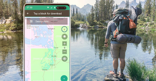
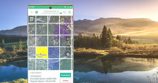
Easy Grid Based Download of Maps
You can try out a simpler approach for downloading and organizing offline maps, choosing large squares at a time. Visualize what you have and what you need.
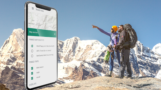
We have a variety of both worldwide and country specific maps that can be downloaded for offline use based on a yearly membership.
Bronze membership to use most maps.
Silver membership to also use slope shaded topo maps of the US, plus US Forest Service maps.
Gold membership to also use Accuterra Maps, with new, readable maps of the US and the World, plus BackRoads MapBook Basemap in Canada.
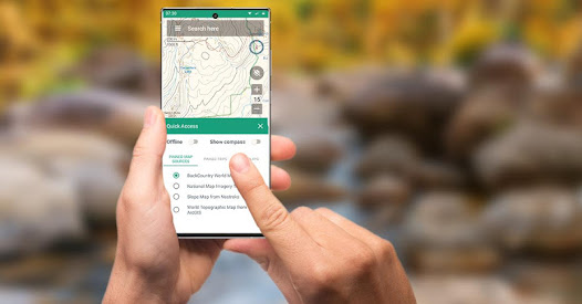
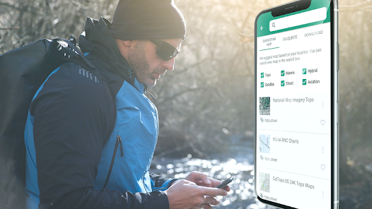
Vector Topo Maps for the World
The default map, BackCountry World map, is a set of Vector topo maps for the world. Vector tiled maps hold the promise of crisp multilevel detail, with the ability to download large chunks of the earth's surface in a quick, compact operation. The BackCountry topo map for the world can be viewed in this app and on bcnavxe.com, with an easy process to install them in large blocks.
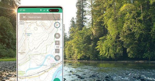
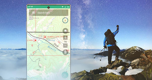
GPS Navigation
Using GPS in a modern day smartphone, see your position on a moving offline map. Find your way to waypoints you mark on the map or create from entering coordinates into the search bar.
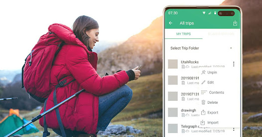
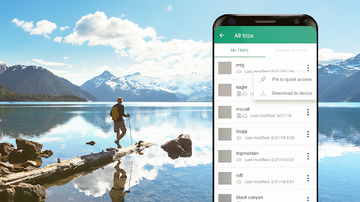
Planning In The Cloud
The website bcnavxe.com is the web interface for BackCountry Navigator XE. With it you can plot points, routes, and boundaries for trips, and download them on demand in the mobile app. You can push trips created in the mobile app to the cloud as well for reviewing or sharing.
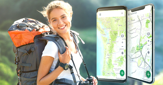
Cross-Platform
BackCountry Navigator XE works on Android, has a newer app in iOS, and a web app to aid in planning at bcnavxe.com.
iOS app is available through Appstore
We are well known for our previous product BackCountry Navigator PRO which is still supported and developed on a parallel track.
https://play.google.com/store/apps/details?id=com.crittermap.backcountrynavigator.license
To see why you might want to upgrade to XE from PRO, see this comparison
You can also subscribe to the XE List to get notified of status, updates, and deals.
Look at the advantages that BackCountry Navigator XE brings to the table.
Easy Grid Based Download of Maps
You can try out a simpler approach for downloading and organizing offline maps, choosing large squares at a time. Visualize what you have and what you need.
We have a variety of both worldwide and country specific maps that can be downloaded for offline use based on a yearly membership.
Bronze membership to use most maps.
Silver membership to also use slope shaded topo maps of the US, plus US Forest Service maps.
Gold membership to also use Accuterra Maps, with new, readable maps of the US and the World, plus BackRoads MapBook Basemap in Canada.
Vector Topo Maps for the World
The default map, BackCountry World map, is a set of Vector topo maps for the world. Vector tiled maps hold the promise of crisp multilevel detail, with the ability to download large chunks of the earth's surface in a quick, compact operation. The BackCountry topo map for the world can be viewed in this app and on bcnavxe.com, with an easy process to install them in large blocks.
GPS Navigation
Using GPS in a modern day smartphone, see your position on a moving offline map. Find your way to waypoints you mark on the map or create from entering coordinates into the search bar.
Planning In The Cloud
The website bcnavxe.com is the web interface for BackCountry Navigator XE. With it you can plot points, routes, and boundaries for trips, and download them on demand in the mobile app. You can push trips created in the mobile app to the cloud as well for reviewing or sharing.
Cross-Platform
BackCountry Navigator XE works on Android, has a newer app in iOS, and a web app to aid in planning at bcnavxe.com.
iOS app is available through Appstore
We are well known for our previous product BackCountry Navigator PRO which is still supported and developed on a parallel track.
https://play.google.com/store/apps/details?id=com.crittermap.backcountrynavigator.license
To see why you might want to upgrade to XE from PRO, see this comparison
You can also subscribe to the XE List to get notified of status, updates, and deals.
Updated on
Safety starts with understanding how developers collect and share your data. Data privacy and security practices may vary based on your use, region, and age. The developer provided this information and may update it over time.


Ratings and reviews
3.4
433 reviews

Brad Jung
- Flag inappropriate
November 17, 2020
This app helped us find our way many times. It takes a bit to learn (because it does so much.) Offline mode is a must and it comes through. There are TOPO maps and they really help navigate. Many maps to choose from. The developer works his tail off to make it more useful. There are trails we would never have found without it.Kudos to the developers.
19 people found this review helpful

BB
- Flag inappropriate
- Show review history
November 24, 2020
5 year gold plan subscriber here, would love to be able to leave a positive review but alas cannot. The focus of the developer has shifted away from basic app functionality and stability to who knows what. Obvious cosmetic bugs (info panels covering important buttons) have went unresolved for a year plus. The developer presence on the support forum is non existent. App functionality is actually decreasing over time. Lately I have started experiencing freezes when the app is put in the background or when switching map sources. If you need a good navigator app the PRO version is a far more trustworthy option than XE. Wish the developer would abandon XE, add vector maps to PRO and provide a reasonable alternative to Caltopo. Would gladly pay $10/year or more just to have something stable that will not crash in the middle of nowhere.
42 people found this review helpful
CritterMap Software LLC
December 12, 2020
We have been able to isolate a freeze in background to specific OnePlus devices. When we are able to spend more time with this device we hope to find a workaround.

Russ Zick
- Flag inappropriate
- Show review history
July 4, 2020
I am struggling to break out of being a 'beginning user' of this app. I started with MotionX, then went to an Android phone and BackCountry Navigator, so I have some experience.I use it mostly for day hikes in new areas near or in National Forests in the Colo mtns. I was one of the Beta testers of this XE and I don't think that worked out for me or Backcountry Navigator. Every new process I try to learn is way harder than I expect it will be. I have learned a few things about base maps with all the stumbling around. It seems that the last great series of maps was the USGS 24000 topo quads during the photo revision era before maps were digital. Now there are a plethora of choices and not one is as thorough, accurate and readable as those pre-digital maps. Yes they are still available, but now they are out of date. It seems most practical to forget their outstanding quality and move along to the new world of custom maps where no one map has all the info you would want. The 2016-2019 versions of the USGS 24000 topo quads disappoint consistently. Missing roads, utility lines, trails all kinds of things shown on the pre-digital maps. Some day these digital maps will be definitively superior, but I haven't seen it yet. Still trying to become proficient with XE. The emails from Nathan have really helped keep me connected to this product. I wish other app creators would copy this excellent follow up service.
22 people found this review helpful
What's new
Fix for some erroneous storage errors.
Waypoint Editing improvements
Fix for marine maps - server change at NOAA.
Updates to billing per Google play
Use Mobac style prebuilt maps.
Ability to show stats for current position when not tracking.
Change coordinates from list of waypoints.
Adjust size of waypoint symbol in settings.
Fix for flash when pinning trip when five are already pinned.
Additional file related fixes.
Fix for sending log failed to helpdesk.
Usability fixes.


