
MapFavs
Contains ads

100+
Downloads

Everyone
info

About this app
MapFavs is a map bookmarking app.
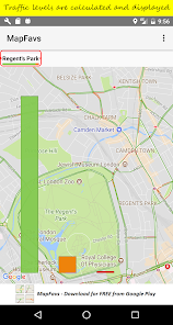
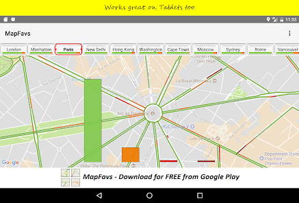
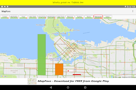
Primarily created to display traffic hotspots when driving around but so much more. The app also summarises traffic levels on each snapshot and shows these levels on the main map and on the snapshot button. Additionally, MapFavs has support for what3words addresses on markers and on the Latitude/Longitude screen.
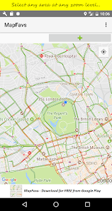
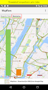
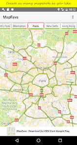
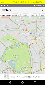
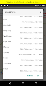
Scroll around maps in the normal way and then snapshot that map so that you can restore that view later with the tap of a button. Each snapshot must have an unique names of course, and they can be reordered and deleted as required.
Operationally the map in MapFavs is either locked or unlocked.
When locked the map is sensitive to taps on the left/right sides, these move to the prev/next snapshot respectively. Doing a long tap in the centre of the map is a quick way to unlock it. Note a helpful overlay can be displayed in locked mode to indicate where the sensitive areas are.
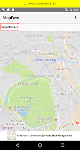
When unlocked the map acts as normal, i.e actions like pinch and swipe work as expected. It's easy to tell when MapFavs is unlocked by the "+" sign at the top right, also if you have allow location permission you will see a "my location" button on the map itself.
If permission allows the app will also automaticallly select the snapshot according to the current location. If the current location is contained within a snapshot then that one is selected (the smallest being preferred) otherwise the closest or one getting closer is selected (see preferences).
By default the screen never locks whilst the app is active however it will dim after a number of seconds (user selectable), a tap on the screen will un-dim. Additionally the screen will automatically undim if traffic levels change significantly or if the snapshot changes of course
Traffic is enabled by default but if you're not using the app for driving then it can be switched off in the preferences. If your using MapFavs for hiking you might want to change map display to Satellite or Hybrid (however I don't believe these work offline).
FAQs
* Why does MapFavs need location access?
Location access allows the app to automatically select the closest snapshot.
* Does the app work without location access?
Yes, but the snapshot autochange feature will be disabled. You won't be able to display the distance to a location either.
* How do I update a snapshot?
Select the snapshot first and then unlock the map. Change the map view as desired and then do a long press on the snapshot button to save your changes.
* Why can't I move the map!!
The map is probably locked, is there a big '+' top right? You can unlock the map with a long centre press or via the main menu. For non drivers you might prefer to have the map unlocked most of the time in which case ensure 'Map Autolock' is off.
* Can I switch off the traffic analysis bars?
Yes. See the preferences and 'Summarise Traffic', you can switch the analysis off completely or if it's just the bars change the display period to zero.
mapfavs@gmail.com
@mapfavs
Primarily created to display traffic hotspots when driving around but so much more. The app also summarises traffic levels on each snapshot and shows these levels on the main map and on the snapshot button. Additionally, MapFavs has support for what3words addresses on markers and on the Latitude/Longitude screen.
Scroll around maps in the normal way and then snapshot that map so that you can restore that view later with the tap of a button. Each snapshot must have an unique names of course, and they can be reordered and deleted as required.
Operationally the map in MapFavs is either locked or unlocked.
When locked the map is sensitive to taps on the left/right sides, these move to the prev/next snapshot respectively. Doing a long tap in the centre of the map is a quick way to unlock it. Note a helpful overlay can be displayed in locked mode to indicate where the sensitive areas are.
When unlocked the map acts as normal, i.e actions like pinch and swipe work as expected. It's easy to tell when MapFavs is unlocked by the "+" sign at the top right, also if you have allow location permission you will see a "my location" button on the map itself.
If permission allows the app will also automaticallly select the snapshot according to the current location. If the current location is contained within a snapshot then that one is selected (the smallest being preferred) otherwise the closest or one getting closer is selected (see preferences).
By default the screen never locks whilst the app is active however it will dim after a number of seconds (user selectable), a tap on the screen will un-dim. Additionally the screen will automatically undim if traffic levels change significantly or if the snapshot changes of course
Traffic is enabled by default but if you're not using the app for driving then it can be switched off in the preferences. If your using MapFavs for hiking you might want to change map display to Satellite or Hybrid (however I don't believe these work offline).
FAQs
* Why does MapFavs need location access?
Location access allows the app to automatically select the closest snapshot.
* Does the app work without location access?
Yes, but the snapshot autochange feature will be disabled. You won't be able to display the distance to a location either.
* How do I update a snapshot?
Select the snapshot first and then unlock the map. Change the map view as desired and then do a long press on the snapshot button to save your changes.
* Why can't I move the map!!
The map is probably locked, is there a big '+' top right? You can unlock the map with a long centre press or via the main menu. For non drivers you might prefer to have the map unlocked most of the time in which case ensure 'Map Autolock' is off.
* Can I switch off the traffic analysis bars?
Yes. See the preferences and 'Summarise Traffic', you can switch the analysis off completely or if it's just the bars change the display period to zero.
mapfavs@gmail.com
@mapfavs
Updated on
Data safety
Developers can show information here about how their app collects and uses your data. Learn more about data safety

No information available
What's new
Added what3words integration!
Latitude/Longitude
* Added the ability to lookup what3words address according to the entered latitude/longitude.
* Added what3words address to shared data, the short address and full url are included.
Edit/Update Marker
* Added the ability to lookup what3words address according to the marker's latitude/longitude.
* Added "Share Location" option that includes what3words data. The marker name, short what3words address and full url are included.


