
Map Pilot Pro

3.8star
252 reviews
50K+
Downloads

Everyone
info


About this app
Based on 8+ years of DJI flight app experience. Map Pilot Pro helps you create and fly the optimal flight path to create great maps using the Maps Made Easy map processing service. Process into the final product using your own photogrammetry software or our Maps Made Easy online service. Mapping has never been easier.
All flight logs and mission planning can be synced with Maps Made Easy's FlightSync system for enhanced debugging and troubleshooting to help users create the best maps around.
Map Pilot Pro is a companion app intended for collecting data for the Maps Made Easy processing platform. Maps Made Easy's processing can be purchased by buying points on a pay-as-you-go basis or it can be subscribed to on a monthly basis.
Collect top notch aerial data using Map Pilot Pro and process unlimited jobs of up to 325 images (12 megapixels) for free with Maps Made Easy.
View Full Documentation: http://support.dronesmadeeasy.com
If it is not available for download from the Play Store you can download the APK from here: https://support.dronesmadeeasy.com/hc/en-us/articles/8160429529876-Installation
Mini 3 and Enterprise aircraft users need to use the APK too.
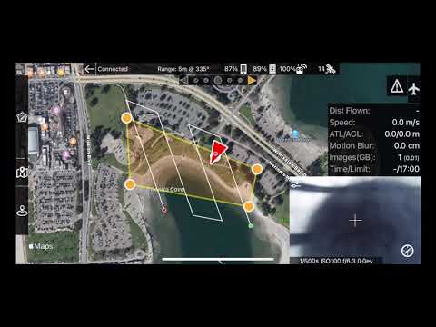
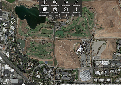
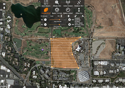
Define the area, select the level of detail, and go.
Features:
Multi-Battery Management
Manual Restart Point Selection
FlightSync to Maps Made Easy
Mission and Boundary Sync with Maps Made Easy
Flight Zone Management
Manual Restart Point definition
Automatic, Aperture/Shutter Priority and Manual Exposure Modes
Basemap Caching for Offline Operations
Connectionless Camera Triggering
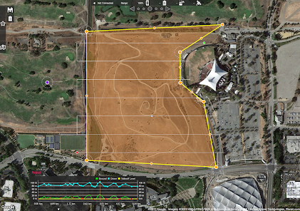
Fully Offline Capable Terrain Awareness
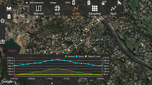
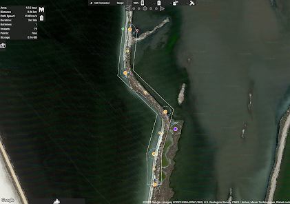
Multi-Pass Linear Mission Planning
Custom Terrain Data Import
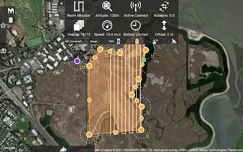
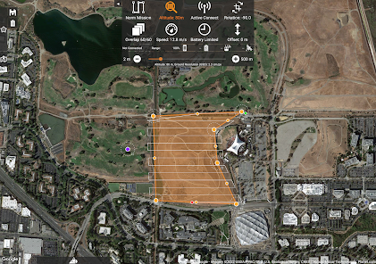
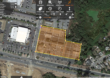
3D Grid Mission Planning
Multi-Flight Coordination
Movable Home Point to Track the Pilot
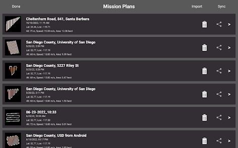
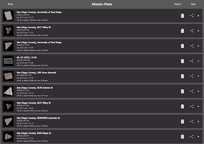
Save/Edit Missions
Re-fly Saved Missions
View 3D logs on-device with Google Earth
Import KML
Export KML, log files and Mission Plans
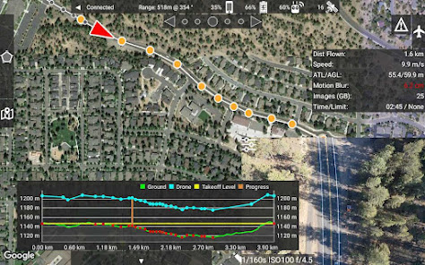
Flight Log review
Built-in Simulator for testing
AirData and DroneLogbook upload from Log File Manager
JPG, RAW and Video recording formats
Fullest Possible Use of Each Battery
Appropriate Camera Triggering
Overlap Management
Speed Management
Automatic Takeoff and Landing
Live Video Preview
Signal Quality Warning
Line of Sight Indicator
Automatically Captures Elevation Reference Image (Ground Image)
Natural Landing Assistance
Live Map View
Supported Aircraft:
See our site for the full list - https://support.dronesmadeeasy.com/hc/en-us/articles/205704366-Supported-Hardware
Mavic Pro
Mavic Air
Air 2 and Air 2S
Mini 2
Mavic 2 (Pro, Zoom, and Enterprise)
Mini 3 and Mini 3 Pro
Phantom 4
Phantom 4 Pro * (v2 included)
Phantom 4 Pro Plus
Phantom 4 RTK
Phantom 4 Advanced
Phantom 3 Professional
Phantom 3 Advanced
Phantom 3 Standard
Inspire 1
Inspire 1 Pro
Inspire 2
Matrice 100 (M100)
Matrice 200 (M200)
Matrice 210 (M210)
Matrice 210 RTK (M210RTK)
Matrice 600 (M600)
Matrice 600P (M600P)
Matrice 300 RTK (M300, M300RTK)
Supported External Cameras:
DJI X3
DJI X5
DJI X4S
DJI X5S
DJI X7
DJI XT2
DJI H20T
DJI H20
P1
All flight logs and mission planning can be synced with Maps Made Easy's FlightSync system for enhanced debugging and troubleshooting to help users create the best maps around.
Map Pilot Pro is a companion app intended for collecting data for the Maps Made Easy processing platform. Maps Made Easy's processing can be purchased by buying points on a pay-as-you-go basis or it can be subscribed to on a monthly basis.
Collect top notch aerial data using Map Pilot Pro and process unlimited jobs of up to 325 images (12 megapixels) for free with Maps Made Easy.
View Full Documentation: http://support.dronesmadeeasy.com
If it is not available for download from the Play Store you can download the APK from here: https://support.dronesmadeeasy.com/hc/en-us/articles/8160429529876-Installation
Mini 3 and Enterprise aircraft users need to use the APK too.
Define the area, select the level of detail, and go.
Features:
Multi-Battery Management
Manual Restart Point Selection
FlightSync to Maps Made Easy
Mission and Boundary Sync with Maps Made Easy
Flight Zone Management
Manual Restart Point definition
Automatic, Aperture/Shutter Priority and Manual Exposure Modes
Basemap Caching for Offline Operations
Connectionless Camera Triggering
Fully Offline Capable Terrain Awareness
Multi-Pass Linear Mission Planning
Custom Terrain Data Import
3D Grid Mission Planning
Multi-Flight Coordination
Movable Home Point to Track the Pilot
Save/Edit Missions
Re-fly Saved Missions
View 3D logs on-device with Google Earth
Import KML
Export KML, log files and Mission Plans
Flight Log review
Built-in Simulator for testing
AirData and DroneLogbook upload from Log File Manager
JPG, RAW and Video recording formats
Fullest Possible Use of Each Battery
Appropriate Camera Triggering
Overlap Management
Speed Management
Automatic Takeoff and Landing
Live Video Preview
Signal Quality Warning
Line of Sight Indicator
Automatically Captures Elevation Reference Image (Ground Image)
Natural Landing Assistance
Live Map View
Supported Aircraft:
See our site for the full list - https://support.dronesmadeeasy.com/hc/en-us/articles/205704366-Supported-Hardware
Mavic Pro
Mavic Air
Air 2 and Air 2S
Mini 2
Mavic 2 (Pro, Zoom, and Enterprise)
Mini 3 and Mini 3 Pro
Phantom 4
Phantom 4 Pro * (v2 included)
Phantom 4 Pro Plus
Phantom 4 RTK
Phantom 4 Advanced
Phantom 3 Professional
Phantom 3 Advanced
Phantom 3 Standard
Inspire 1
Inspire 1 Pro
Inspire 2
Matrice 100 (M100)
Matrice 200 (M200)
Matrice 210 (M210)
Matrice 210 RTK (M210RTK)
Matrice 600 (M600)
Matrice 600P (M600P)
Matrice 300 RTK (M300, M300RTK)
Supported External Cameras:
DJI X3
DJI X5
DJI X4S
DJI X5S
DJI X7
DJI XT2
DJI H20T
DJI H20
P1
Updated on
Safety starts with understanding how developers collect and share your data. Data privacy and security practices may vary based on your use, region, and age. The developer provided this information and may update it over time.


Ratings and reviews
3.8
245 reviews

Jeff Voight
- Flag inappropriate
February 27, 2023
Two weeks after paying for the app, they changed something and now it isn't compatible with any of my android devices, specifically the S8+. Upgrades aren't supposed to remove functionality, but this one removed ALL functionality. And, this isn't the first time they've pushed a bad app. It makes me think that nobody is testing anything prior to deployment.
40 people found this review helpful
Maps Made Easy
August 28, 2023
8/27/23 - This review was left well over 20 releases ago when we were just getting Android started. The S8+ is supported and this user has used it to fly successfully 20+ times since leaving this review. There is more good news though! You can still get the APK from our support site if you have trouble installing the app.

Noel Gallagher
- Flag inappropriate
- Show review history
May 2, 2024
A very solid app for mapping with your DJI drone. Creates solid maps and models from the start. The app is intuitive and after following the guides & a little practice you can easily achieve impressive results and solid data without having to use ridiculously expensive or command line options. I particularly like being able to share a link with the customer so they can view the map or model while I download the package to work with in Trimble, GIS and blender. Great support also.
3 people found this review helpful

Joseph F Dunphy MBA
- Flag inappropriate
June 8, 2024
This comes recommended with the package I ordered. So I m giving it a try. I need to do a few flights with it before I can see if it will work for the applications I wanted it for.
What's new
Added better Terrain Awareness image spacing to KMZ Export
Changed "Heavy Trees" overlap suggestion to 85%
Added redirect to 'b' variant for Android 14 compatibility
Changed "Heavy Trees" overlap suggestion to 85%
Added redirect to 'b' variant for Android 14 compatibility
App support
phone
Phone number
+18443128444


