
Earth Explorer
100+
Downloads

Everyone
info
About this app
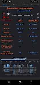
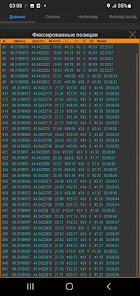
Real-time GPS location data.
Track recording in gpx, kml format.
The program always maintains GPS connection even when the screen is turned off. This way, you won't lose your GPS fix when your phone goes to sleep.
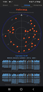
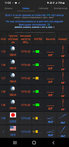
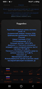
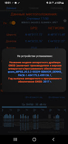
The program displays real-time information for satellites in the device's field of view.
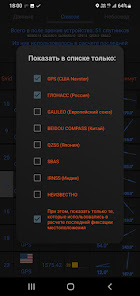
Supports:
• GPS (USA Navstar)
• GLONASS (Russia)
• GALILEO (European Union)
• QZSS (Japan)
• BeiDou / COMPASS (China)
•SBAS
You can also see the location determined by the network.
And thus, on one screen, compare the difference in location accuracy from two providers. Network provider and GPS provider.
GPS signal histograms:
• Baseband carrier-to-noise density of DB-Hz satellites.
• Carrier-to-noise ratio density at the DB-Hz satellite antenna.
• Location of satellites in the sky (sky view)
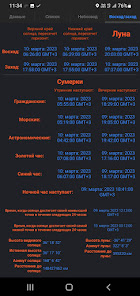
The program also provides sunrise/sunset information. Astronomical, navigational and civil twilight. The time when the golden, blue and night hours come.
The time when the sun reaches its highest and lowest point.
Moonset/rise.
Distance to the moon in kilometers.
Azimuth of the moon.
Height of the moon.
Open source on Github:
https://github.com/StalkerExplorer/Earth-Explorer
Discussion of the program on w3bsit3-dns.com:
https://4pda.to/forum/index.php?showtopic=1065109
Track recording in gpx, kml format.
The program always maintains GPS connection even when the screen is turned off. This way, you won't lose your GPS fix when your phone goes to sleep.
The program displays real-time information for satellites in the device's field of view.
Supports:
• GPS (USA Navstar)
• GLONASS (Russia)
• GALILEO (European Union)
• QZSS (Japan)
• BeiDou / COMPASS (China)
•SBAS
You can also see the location determined by the network.
And thus, on one screen, compare the difference in location accuracy from two providers. Network provider and GPS provider.
GPS signal histograms:
• Baseband carrier-to-noise density of DB-Hz satellites.
• Carrier-to-noise ratio density at the DB-Hz satellite antenna.
• Location of satellites in the sky (sky view)
The program also provides sunrise/sunset information. Astronomical, navigational and civil twilight. The time when the golden, blue and night hours come.
The time when the sun reaches its highest and lowest point.
Moonset/rise.
Distance to the moon in kilometers.
Azimuth of the moon.
Height of the moon.
Open source on Github:
https://github.com/StalkerExplorer/Earth-Explorer
Discussion of the program on w3bsit3-dns.com:
https://4pda.to/forum/index.php?showtopic=1065109
Updated on
Safety starts with understanding how developers collect and share your data. Data privacy and security practices may vary based on your use, region, and age. The developer provided this information and may update it over time.

No data shared with third parties
Learn more about how developers declare sharing

No data collected
Learn more about how developers declare collection
What's new
Запись трека в формате GPX, KML.


