

Metar-Taf - Visual decoder

4,8star
558 recenzija
5 hilj.+
Preuzimanja

Svako
info


O aplikaciji
Visualized METAR and TAF weather information for all airports in the world. Concise summary of everything you need to know about today's aviation weather.
METAR features:
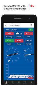
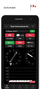
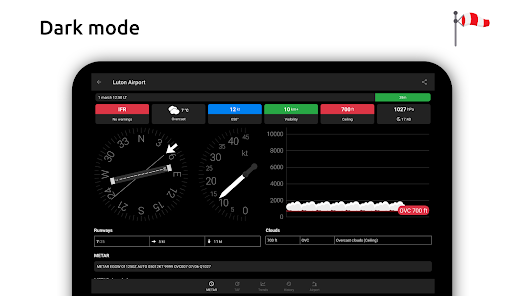
- Visualized in easy to understand and colourful metrics
- Weather symbols for significant weather and clouds, like in a non-aviation weather report
- Crosswind calculations, by combining METAR and runway information
- Flight rules category: VFR, MVFR, IFR, LIFR
- Read out by text-to-speech available, listen to a decoded METAR while doing other things
TAF features:
- TAF broken down and displayed per hour in a table
- Show sunrise/sunset, minimum and maximum temperature
NOTAM features:
- Timeline with NOTAMs sorted by issue date
- Coordinates from NOTAMs plotted on map
Keeping track:
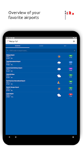
- Add your favorite stations to the list, see their weather at a glance
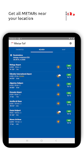
- Get observations near your location
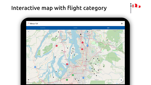
- Find stations in the interactive map with weather codes
- Search airports by ICAO code or name
History:
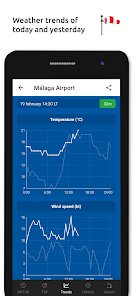
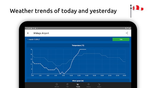
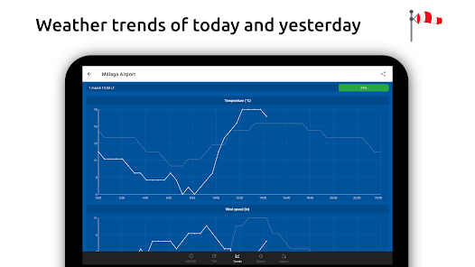
- Graphs with weather trends today and yesterday: temperature, visibility, wind speed, QNH
- METAR history for the last hours and link to more on the website
Airport information:
- See information about the airports, like runway directions, elevation, location
- If the airport doesn't report a METAR, the nearest station used for calculations
Calculations:
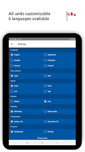
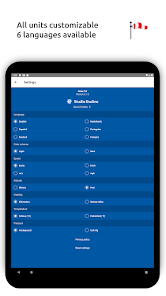
- All units are customizable units: speed (knots, km/h, m/s, mph), altitude (meters/feet), visibility (kilometers/miles), temperature (Celcius/Fahrenheit) and air pressure (Hectopascal, Inch Hg)
- Times are converted to the local time for each airport
- Sunrise and sunset are calculated based on the airports latitude/longitude
General:
- METAR, TAF and airport data are automatically saved for offline use
- Available in 6 languages: English, Dutch, Spanish, Portuguese, German and French
METAR features:
- Visualized in easy to understand and colourful metrics
- Weather symbols for significant weather and clouds, like in a non-aviation weather report
- Crosswind calculations, by combining METAR and runway information
- Flight rules category: VFR, MVFR, IFR, LIFR
- Read out by text-to-speech available, listen to a decoded METAR while doing other things
TAF features:
- TAF broken down and displayed per hour in a table
- Show sunrise/sunset, minimum and maximum temperature
NOTAM features:
- Timeline with NOTAMs sorted by issue date
- Coordinates from NOTAMs plotted on map
Keeping track:
- Add your favorite stations to the list, see their weather at a glance
- Get observations near your location
- Find stations in the interactive map with weather codes
- Search airports by ICAO code or name
History:
- Graphs with weather trends today and yesterday: temperature, visibility, wind speed, QNH
- METAR history for the last hours and link to more on the website
Airport information:
- See information about the airports, like runway directions, elevation, location
- If the airport doesn't report a METAR, the nearest station used for calculations
Calculations:
- All units are customizable units: speed (knots, km/h, m/s, mph), altitude (meters/feet), visibility (kilometers/miles), temperature (Celcius/Fahrenheit) and air pressure (Hectopascal, Inch Hg)
- Times are converted to the local time for each airport
- Sunrise and sunset are calculated based on the airports latitude/longitude
General:
- METAR, TAF and airport data are automatically saved for offline use
- Available in 6 languages: English, Dutch, Spanish, Portuguese, German and French
Ažurirano dana
Sigurnost počinje razumijevanjem na koji način programeri prikupljaju i dijele vaše podatke. Privatnost podataka i sigurnosne prakse se mogu razlikovati ovisno o korištenju, regiji i dobi. Programer je pružio ove informacije i može ih s vremenom ažurirati.

Podaci se ne dijele s trećim stranama
Saznajte više o načinu na koji programeri pružaju izjavu o dijeljenju

Podaci se ne prikupljaju
Saznajte više o načinu na koji programeri pružaju izjavu o prikupljanju

Podaci su šifrirani u prijenosu

Podaci se ne mogu izbrisati
Ocjene i recenzije
4,8
487 recenzija


