
GPS Land Measurement & Survey
In-app purchases

3.7star
985 reviews

Everyone
info
100K+
Downloads

Everyone
Learn more


About this app
GPS Area Measure - Mapulator is the perfect map calculator for anyone needing precise area measurement, perimeter, and distance calculations on a map. Ideal for land measurement, agriculture, surveying, and construction, this area app delivers accurate results. 🌍
Unleash the power of accurate area and distance measurement with GPS Area Measure - Mapulator, the ultimate mapping tool for professionals and enthusiasts alike. Whether you're a land surveyor, real estate agent, farmer (using agro-measure map pro), construction manager, or simply curious about the dimensions of your surroundings, Mapulator provides the precision and flexibility you need. Effortlessly calculate areas (area app, area land calculator), distances (measured distance), and radii (radius map) directly on the map, transforming your mobile device into a powerful measurement instrument (measurable).📱
Key Features of GPS Area Measure - Mapulator:
• 5 Measurement Tools: This area measurement app offers five tools for area calculators for land, perimeter and area, and radius map measurements.
• Supports Area, Distance, and Radius: Calculate GPS measurement accurately, whether acres, hectares, or other units.
• Multiple Layers within a Project: Organize land area calculator projects with multiple layers.
• 9 Area and 6 Distance Units: Measure land area units such as acres, hectares, square feet(Sq ft),
• Customizable Appearance: Adjust line width, line color, and fill color.
• Multiple Map Types: Use map measurement with satellite, terrain, and hybrid maps.
• GPS Live Measurement: Measure the land area in real-time using the Live GPS field area measure app.
• Location Search: Find any location for accurate agro-measure map pro results.
• Undo/Redo: Correct errors using your land area calculator app.
Export and Share: Share your area survey and GPS measure results in KML or GeoJson.
Why Choose GPS Area Measure - Mapulator?
• Precision: Get GPS area measurement with reliable accuracy.
• User-Friendly: This area measurement app is excellent for professionals and beginners alike.
• Versatile: Ideal for agro-measure map pro needs, land measure, and area land calculator uses.
• Customizable Tools: Perfect for land measurement, perimeter, and area calculations.
• Real-Time GPS Measurement: Walk and measure with GPS area measure.
Who Can Benefit?
• Farmers: Use the area app for agro-measure map pro and land area calculator tasks.
• Surveyors: Conduct accurate area surveys with this GPS field area measure app.
• Construction Pros: Manage land measurement efficiently.
• Real Estate Agents: Provide clients with Accurate perimeter and area data.
• Outdoor Enthusiasts: Measure trails with the area measurement app.
• Roof layers or other roofing needs.
How to Use the App?
• Select Tool: Choose area measure or distance.
• Mark Points: Use the map measurement tool.
• Settings: Adjust line width and color.
• Use GPS Live: Enable GPS measurement in real-time.
• Save/Export: Export your land area calculator projects.
Customize Your Measurements:
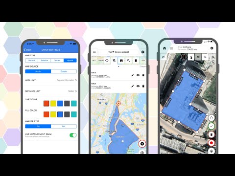
Personalize your measurements with Mapulator's customization options. Adjust the line width for clear visibility, choose from a spectrum of line colors to differentiate between measurements, and apply fill colors to area measurements for enhanced visualization. These customization options help you create clear, informative maps that meet your needs. 👈
Multiple Map Types:
Visualize your measurements on your preferred map type. Mapulator supports multiple map types, allowing you to choose the view that best suits your project. Whether you prefer a detailed street map, a topographic view, or a satellite image, provides the flexibility to adapt to your needs.🥰
Integrate with other tools:
Export KML and GeoJSON for area calculations.
Make land measurement, GPS measure, and perimeter and area calculations effortless.
→ Privacy policy: https://mapulator.app/privacy-policy/
→ Terms of Use: https://mapulator.app/terms-and-conditions/
Unleash the power of accurate area and distance measurement with GPS Area Measure - Mapulator, the ultimate mapping tool for professionals and enthusiasts alike. Whether you're a land surveyor, real estate agent, farmer (using agro-measure map pro), construction manager, or simply curious about the dimensions of your surroundings, Mapulator provides the precision and flexibility you need. Effortlessly calculate areas (area app, area land calculator), distances (measured distance), and radii (radius map) directly on the map, transforming your mobile device into a powerful measurement instrument (measurable).📱
Key Features of GPS Area Measure - Mapulator:
• 5 Measurement Tools: This area measurement app offers five tools for area calculators for land, perimeter and area, and radius map measurements.
• Supports Area, Distance, and Radius: Calculate GPS measurement accurately, whether acres, hectares, or other units.
• Multiple Layers within a Project: Organize land area calculator projects with multiple layers.
• 9 Area and 6 Distance Units: Measure land area units such as acres, hectares, square feet(Sq ft),
• Customizable Appearance: Adjust line width, line color, and fill color.
• Multiple Map Types: Use map measurement with satellite, terrain, and hybrid maps.
• GPS Live Measurement: Measure the land area in real-time using the Live GPS field area measure app.
• Location Search: Find any location for accurate agro-measure map pro results.
• Undo/Redo: Correct errors using your land area calculator app.
Export and Share: Share your area survey and GPS measure results in KML or GeoJson.
Why Choose GPS Area Measure - Mapulator?
• Precision: Get GPS area measurement with reliable accuracy.
• User-Friendly: This area measurement app is excellent for professionals and beginners alike.
• Versatile: Ideal for agro-measure map pro needs, land measure, and area land calculator uses.
• Customizable Tools: Perfect for land measurement, perimeter, and area calculations.
• Real-Time GPS Measurement: Walk and measure with GPS area measure.
Who Can Benefit?
• Farmers: Use the area app for agro-measure map pro and land area calculator tasks.
• Surveyors: Conduct accurate area surveys with this GPS field area measure app.
• Construction Pros: Manage land measurement efficiently.
• Real Estate Agents: Provide clients with Accurate perimeter and area data.
• Outdoor Enthusiasts: Measure trails with the area measurement app.
• Roof layers or other roofing needs.
How to Use the App?
• Select Tool: Choose area measure or distance.
• Mark Points: Use the map measurement tool.
• Settings: Adjust line width and color.
• Use GPS Live: Enable GPS measurement in real-time.
• Save/Export: Export your land area calculator projects.
Customize Your Measurements:
Personalize your measurements with Mapulator's customization options. Adjust the line width for clear visibility, choose from a spectrum of line colors to differentiate between measurements, and apply fill colors to area measurements for enhanced visualization. These customization options help you create clear, informative maps that meet your needs. 👈
Multiple Map Types:
Visualize your measurements on your preferred map type. Mapulator supports multiple map types, allowing you to choose the view that best suits your project. Whether you prefer a detailed street map, a topographic view, or a satellite image, provides the flexibility to adapt to your needs.🥰
Integrate with other tools:
Export KML and GeoJSON for area calculations.
Make land measurement, GPS measure, and perimeter and area calculations effortless.
→ Privacy policy: https://mapulator.app/privacy-policy/
→ Terms of Use: https://mapulator.app/terms-and-conditions/
Updated on
Safety starts with understanding how developers collect and share your data. Data privacy and security practices may vary based on your use, region, and age. The developer provided this information and may update it over time.

No data shared with third parties
Learn more about how developers declare sharing

No data collected
Learn more about how developers declare collection

Data is encrypted in transit

You can request that data be deleted
Ratings and reviews
3.7
938 reviews

Jeremy MacWilliam
- Flag inappropriate
May 7, 2026
got the app to show where I had dug up some rocks. tried to share it, and lost some of the points somehow that I had saved. waste of time
1 person found this review helpful
LogiSian
May 8, 2026
Thank you for your feedback, and we’re sorry about your experience. The points should normally remain saved when sharing, so this may have been an unexpected issue. Please contact us at support@mapulator.app with details of what happened, and we’ll do our best to help and improve the app. Team Mapulator

Randy Curtiss
- Flag inappropriate
April 17, 2026
make sure you take screenshots before you try to save it because after you complete one project and type the name in it it informs you you have to pay to save. And this is after you fight with the UI for an hour. why pay for this if you can't get the free version right.
1 person found this review helpful
LogiSian
April 18, 2026
Thanks for your feedback.
Can you also send us a video recording at support@mapulator.app, we will try to fix this issue soon.

Mohaila
- Flag inappropriate
June 24, 2026
Useless. Doesn't go beyond loading
LogiSian
June 26, 2026
Thank you for your feedback, and we’re sorry to hear about your experience. The app should load normally, so this appears to be an unexpected issue. Please contact us at support@mapulator.app with your device model and OS version. We’ll investigate the issue and do our best to resolve it quickly. Team Mapulator
What’s new
• Bug fixes and performance improvements.
Everyone
Learn moreApp support
About the developer
LogiSian Technology Solutions Pvt. Ltd.
support@logisian.in
Harikripa
Govt Quarters Road
Mangaluru, Karnataka 575006
India
+91 80885 72172


