

Navigraph Charts

4,8star
1,31K avis
50K+
Téléchargements

Tout public
info


À propos de l'application
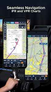
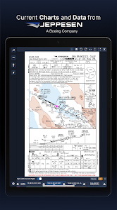
Looking for the most comprehensive software solution for flight simulation? Navigraph Charts is your co-pilot.
Navigraph Charts 8 has been developed with emphasis on delivering a seamless and intuitive experience, reducing the pilot workload in all phases of the simulated flight.
Why you'll always want Navigraph Charts with you in the cockpit:
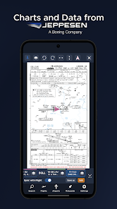
- Only provider of Jeppesen charts and navigation data for flight simulation.
- Access to IFR chart coverage at over 7,000 airport worldwide.
- Charts and data sourced from Jeppesen and updated every 28 days according to the AIRAC calendar.
- Largest dataset of its kind in the world.
- Most up-to-date and modern navigation software for flight simulation.
- Simulator sceneries, flight plans, charts, navigation systems, and addon software are all in sync with data from the same source.
- Great support.
New features in Navigraph Charts 8:
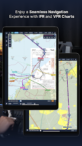
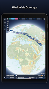
- Worldwide VFR Charts powered by Jeppesen VFR data
- Seamless Zoom
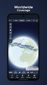
- 3D Globe Projection
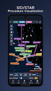
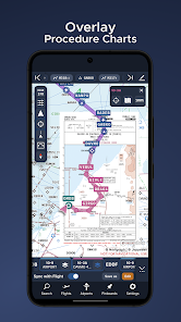
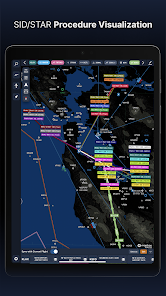
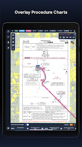
- Autopinning of Procedure Charts
- Runway Crosswind and Airport Weather Information
- Vector Charts
Navigraph Unlimited features:
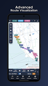
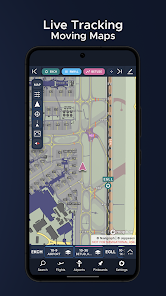
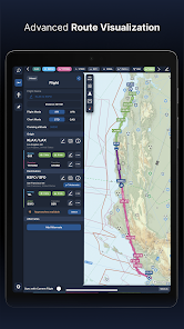
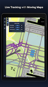
- Moving Maps
- Zoom all the way down to gate level.
- 3D globe projection helps visualize Great Circle distances and polar routes.
- Saves time and effort by automatically organizing relevant airport charts to pinboard.
- Weather information including runway crosswinds updated in real-time.
- No commitment - cancel any time you like.
Moving Maps compatible with Microsoft Flight Simulator, X-Plane and Prepar3d.
For the best user experience, we recommend using a tablet. Support for smaller displays is under development. Navigraph Charts is also available as a stand alone software on desktop computers, and can also be accessed on any web browser via https://charts.navigraph.com.
For complete terms of service, please visit https://navigraph.com/legal/terms-of-service
For privacy policy, please visit https://navigraph.com/legal/privacy-policy
Navigraph Charts 8 has been developed with emphasis on delivering a seamless and intuitive experience, reducing the pilot workload in all phases of the simulated flight.
Why you'll always want Navigraph Charts with you in the cockpit:
- Only provider of Jeppesen charts and navigation data for flight simulation.
- Access to IFR chart coverage at over 7,000 airport worldwide.
- Charts and data sourced from Jeppesen and updated every 28 days according to the AIRAC calendar.
- Largest dataset of its kind in the world.
- Most up-to-date and modern navigation software for flight simulation.
- Simulator sceneries, flight plans, charts, navigation systems, and addon software are all in sync with data from the same source.
- Great support.
New features in Navigraph Charts 8:
- Worldwide VFR Charts powered by Jeppesen VFR data
- Seamless Zoom
- 3D Globe Projection
- Autopinning of Procedure Charts
- Runway Crosswind and Airport Weather Information
- Vector Charts
Navigraph Unlimited features:
- Moving Maps
- Zoom all the way down to gate level.
- 3D globe projection helps visualize Great Circle distances and polar routes.
- Saves time and effort by automatically organizing relevant airport charts to pinboard.
- Weather information including runway crosswinds updated in real-time.
- No commitment - cancel any time you like.
Moving Maps compatible with Microsoft Flight Simulator, X-Plane and Prepar3d.
For the best user experience, we recommend using a tablet. Support for smaller displays is under development. Navigraph Charts is also available as a stand alone software on desktop computers, and can also be accessed on any web browser via https://charts.navigraph.com.
For complete terms of service, please visit https://navigraph.com/legal/terms-of-service
For privacy policy, please visit https://navigraph.com/legal/privacy-policy
Date de mise à jour
La sécurité, c'est d'abord comprendre comment les développeurs collectent et partagent vos données. Les pratiques concernant leur confidentialité et leur protection peuvent varier selon votre utilisation, votre région et votre âge. Le développeur a fourni ces informations et peut les modifier ultérieurement.

Aucune donnée partagée avec des tiers
En savoir plus sur la manière dont les développeurs déclarent le partage

Aucune donnée collectée
En savoir plus sur la manière dont les développeurs déclarent la collecte
Notes et avis
4,7
737 avis
Nouveautés
- Added "Land Cover" layer with forests and glaciers for enhanced situational awareness
- Added "Terminator" layer depicting the border between the daylit side and the dark night side of Earth
- Fixed formatting issue in Simlink message
- Removed unintentional whitespace at the bottom of the OFP
- Fixed a bug that made it impossible to switch Navigraph account
Full changelog at navigraph.com/apps/charts/changelog


